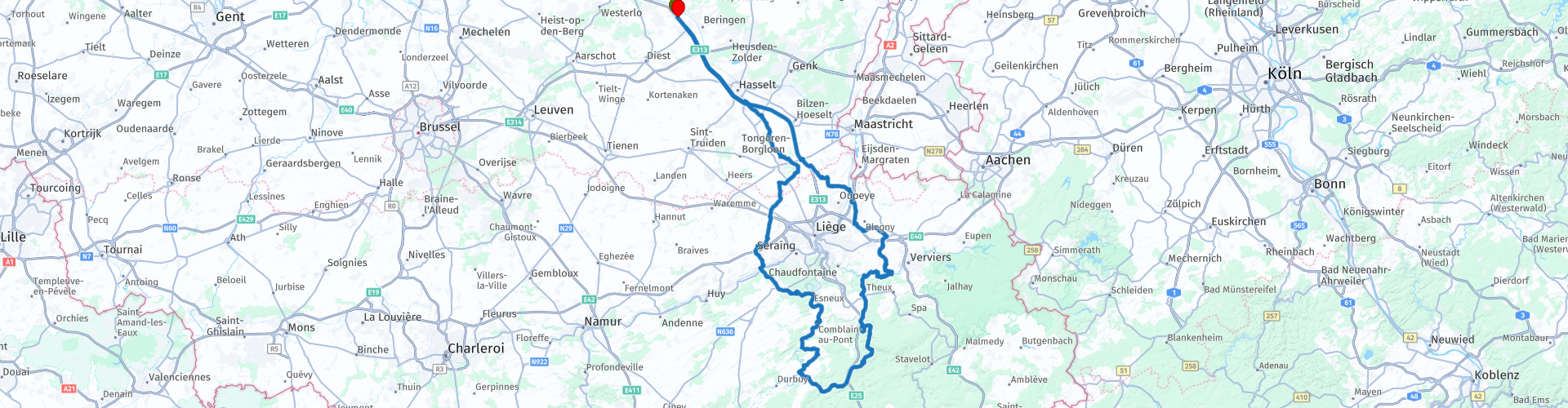
Rivertour around Liege out of Tessenderlo

This route was brought to you by:
RouteXpert Guy Heyns - Sr RouteXpert
Last edit: 10-12-2024
 Route Summary
 It is a pleasant tour that gives you a taste of Walloon driving pleasure and introduces you to some typical and fun Walloon roads.
 Share this route


Animation

Verdict


Duration
5h 52m

Mode of travel
Car or motorcycle

Distance
276.09 km

Countries

 RouteXpert Review
 You will also get to know some typical - and important - rivers for Wallonia, such as the Ourthe, the Amblève and the Meuse.
The route starts at the Total petrol station next to the E313 in Tessenderlo. Enough space to meet each other, drink a cup of coffee and, if necessary, take a pee.
After a few kilometers of highway, we leave the highway near Tongeren (the oldest city in Belgium) to take field roads to the Walloon road network. In Flanders, the speed is limited to 70 km/h outside built-up areas, in Wallonia it can be slightly faster (90 km/h).
You will first cross the Meuse, a river that has an important economic influence, not only on Wallonia, but on its entire basin.
After some beautiful roads, you arrive in Pepinster, the once beautiful, quiet village on the Vesdre, a river that - thanks to Walloon stupidity and idiocy at its finest - has caused enormous havoc in this once peaceful village along the Vesdre.
Naturally, the extremely high rainfall in July 2021 is the major cause of the flooding in Pepinster, but the big question remains whether the damage could not have been immensely limited by timely intervention by the Walloon government with regard to water management in the various dams.
Due to the crushing responsibility and the related direct costs, this question may never be answered, unless of course by the victims who - 3 years after the disaster - are still hungry.
It is certain that immense mistakes were also made during the provision of aid, whereby - also by aid organizations - their own interests unfortunately gained the upper hand.
The Pepinster disaster is therefore an absolute disgrace of failed government and aid policy, where fortunately a number of volunteers provided the help that was ultimately needed over a very long time.
The route itself passes through Pepinster and then continues for a while along the Vesder.
After leaving the Vesdre we dive south deeper into Wallonia to reach the Amblève.
The Amblève winds over a length of 93 kilometers through the picturesque landscape south of the city of Liège. The Amblève has not only marked the landscape, but has also created famous caves (Rémouchamps) and - although artificial - one of the most famous waterfalls in Belgium when monks in Coo diverted the stream to power a water mill.
After finishing the route we drive back north where we reach the Ourthe, which flows through a number of very touristy towns that naturally benefit from the beauty of the river. La Roche en Ardenne, Durbuy (the smallest town in the world (they say)) are just a few examples.
In Comblain au Pont you can make a stop along the river and then drive back in the direction of the urban area around Liège.
Along this route you will also pass Liège airport, originally built for military purposes, but today aimed more at commercial use, mainly for the transport of goods.
From Liège it goes back through Tongeren - the oldest city in Belgium - to take the highway in Hasselt back to Tessenderlo.


 Links
Links  Usage
Usage Want to download this route?
You can download the route for free without MyRoute-app account. To do so, open the route and click 'save as'. Want to edit this route?
No problem, start by opening the route. Follow the tutorial and create your personal MyRoute-app account. After registration, your trial starts automatically.  Disclaimer
Use of this GPS route is at your own expense and risk. The route has been carefully composed and checked by a MyRoute-app accredited RouteXpert for use on TomTom, Garmin and MyRoute-app Navigation.
Changes may nevertheless have occurred due to changed circumstances, road diversions or seasonal closures. We therefore recommend checking each route before use.
Preferably use the route track in your navigation system. More information about the use of MyRoute-app can be found on the website under 'Community' or 'Academy'.

Liège Province
About this region
Liège (French: [ljɛʒ]; Walloon: Lîdje [liːtʃ]; Dutch: Luik [lœyk] (About this soundlisten); German: Lüttich [ˈlʏtɪç] (About this soundlisten)) is the easternmost province of Wallonia and Belgium.
It borders (clockwise from the north) the Dutch province of Limburg, the German states of North Rhine-Westphalia and Rhineland-Palatinate, Diekirch in Luxembourg, the Belgian Walloon (French-speaking) provinces of Luxembourg, Namur and Walloon Brabant and the Belgian Flemish (Dutch-speaking) provinces of Flemish Brabant and Limburg.
Part of the eastern-most area of the province, bordering Germany, is the German-speaking region of Eupen-Malmedy, which became part of Belgium in the aftermath of World War I.
The capital and the largest city of the province is the city of the same name, Liège. The province has an area of 3,857 km2 (1,489 sq mi), and a population of 1,106,992 as of January 2019.[4]
Read more on Wikipedia
It borders (clockwise from the north) the Dutch province of Limburg, the German states of North Rhine-Westphalia and Rhineland-Palatinate, Diekirch in Luxembourg, the Belgian Walloon (French-speaking) provinces of Luxembourg, Namur and Walloon Brabant and the Belgian Flemish (Dutch-speaking) provinces of Flemish Brabant and Limburg.
Part of the eastern-most area of the province, bordering Germany, is the German-speaking region of Eupen-Malmedy, which became part of Belgium in the aftermath of World War I.
The capital and the largest city of the province is the city of the same name, Liège. The province has an area of 3,857 km2 (1,489 sq mi), and a population of 1,106,992 as of January 2019.[4]
View region
 Statistics
  75
75Amount of RX reviews (Liège Province)
 41533
41533Amount of visitors (Liège Province)
 19122
19122Amount of downloads (Liège Province)
 Route Collections in this region
 The 10 most beautiful car and motorcycle routes in Limburg
Limburg, who thinks of Limburg, thinks of flan, coal mines, marl and the hill country. The coal mines have been closed for almost 40 years, the last load of coal was brought up from the Oranje-Nassau coal mine in Heerlen on 31 December and, as they say, South Limburg was transformed from Black to Green and unfortunately there is still little left. view of this period.
But not only pie, marl and coal in Limburg, but also a very beautiful province to tour by car or motorcycle and enjoy all the beauty that the province of Limburg has to offer. For this, the MyRoute app RouteXpert has put together a Top 10 of Car and Motorcycle routes for you.
All routes in this collection have been checked and made equal for TomTom, Garmin and MyRoute-app Navigation by a MyRoute-app RouteXpert.
If you think, I have a very nice route that should certainly not be missing from this collection, send it to:
email: routeexpert@myrouteapp.com
Subject: New Route for the Top 10 collection Province of Limburg composed by Hans van de Ven.
The route will then be reviewed and then added to the Top 10.
To make the Top 10 also the Top 10, 1 route will have to disappear from the Top 10, you can indicate this when submitting the new route.
Have fun with this collection and while driving one of these routes. Enjoy all the beauty that the Netherlands and in particular the province of Limburg has to offer. Click on “View route” to read the review of the chosen route.
I would like to hear your findings about the route(s).
View Route Collection
Top 5 Car and Motorcycle Routes in the Eifel
The Eifel is the eastern part of the medium plateau Eifel-Ardennes. It is located north of the Moselle and west of the Rhine. The largest part is in Germany, a small part is in Belgium, in the East Cantons. The German part of Eifel is located in the federal states of North Rhine-Westphalia and Rhineland-Palatinate. The highest point is the Hohe Acht with 747 meters.
Several chains can be distinguished in the Eifel:
The northernmost part is called the Nordeifel, which in Belgium connects to the High Fens;
To the east of this is the Ahrgebirge, this part is located north of the Ahr in the Ahrweiler district;
South of the Ahr is the Hohe Eifel (or Hocheifel), of which the Hohe Acht (747 m) is the highest point, and also the highest point in the entire Eifel region;
To the west, near the Belgian border, the hills are known as Schneifel, part of the wider Snow Eifel area with peaks reaching up to 698 metres;
South and east of the Hohe Eifel is the Volcano-Eifel, a volcanic area with many crater lakes (Maare).
The southern part of the Eifel is less high. The area is bisected by streams and rivers running southwards. These streams flow into the Moselle. The largest of these rivers is the Kyll; the hills around this river are known as the Kyllwald;
In the south, the Eifel ends in the Voreifel.
In the north of the Eifel there are some large reservoirs. The largest of these is the reservoir in the Roer that was created by the construction of the Roerdal dam.
The Nürburgring is also located in the Eifel, a well-known car circuit for Formula 1 races, among other things. Since 2004, part of the north of the Eifel has become the Eifel National Park. This National Park falls entirely within the German-Belgian nature park High Fens-Eifel. Another part of the Eifel falls within the South Eifel Nature Park.
Well-known throughout the Netherlands and Belgium by car and motorcyclists, so reason enough for the MyRoute app RouteXpert to compile a Top 5 of Car and Motorbike routes for you.
All routes in this collection have been checked and made equal for TomTom, Garmin and MyRoute-app Navigation by a MyRoute-app RouteXpert.
If you think, I have a very nice route that should certainly not be missing from this collection, send it to:
email: routeexpert@myrouteapp.com
Subject: New Route for the Top 5 collection Eifel composed by Hans van de Ven.
The route will then be reviewed and then added to the Top 5. To make the Top 5 also the Top 5, 1 route will have to disappear from the Top 5, you can indicate this when submitting the new route.
Have fun with this collection and while driving one of these routes. Enjoy all the beauty that the Eifel has to offer. Click on “View route” to read the review of the chosen route.
I would like to hear your findings about the route(s).
View Route Collection