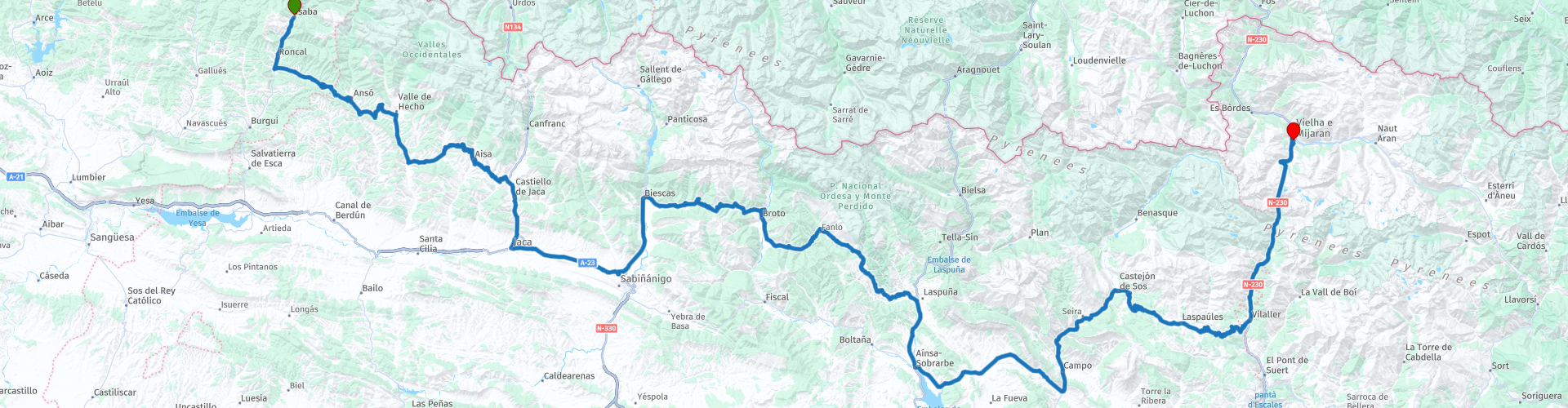
Isaba to Vielha

This route was brought to you by:
RouteXpert Jannes van Dijken
Last edit: 22-04-2024
 Route Summary
 This is the northernmost paved route through the Pyrenees. The view of several National Parks and the immediate surroundings gives you a feeling of surrender to nature. The landscape is enchanting and relaxing throughout the route.
I gave this route 5 stars because most of the roads, with the exception of sometimes poorer sections on narrow mountain roads, are good. The environment is a big picture book throughout the entire route. The abundance of bends and the many climbs make this a very beautiful route.
 Share this route


Animation

Verdict


Duration
8h 27m

Mode of travel
Car or motorcycle

Distance
304.79 km

Countries

 RouteXpert Review
 The first hours you can enjoy the surroundings and the view of the higher mountains in the north. Sometimes straight, sometimes with several hairpin bends in succession, the route slowly takes you further to the East. After almost 2 hours you will arrive at Castiello de Jaca, a good place for coffee. In addition to coffee, at bar-restaurant Casa Pío they also have a delicious cheesecake or Spanish tarta de queso.
After a short break, the route continues south and you will soon arrive in historic Jaca, a city with a rich history and a unique culture. Here is also the well-preserved fortress from the 16th century, la Ciudadela de Jaca. Well worth it for a quick stop and some photos. With a bit of luck you will also see the deer at the old fort, they have now become a symbol of the city and the fort. These Iberian deer were released here in 1974 and the population is still growing. A parking spot for the motorcycle, near the entrance, is indicated on the route map.
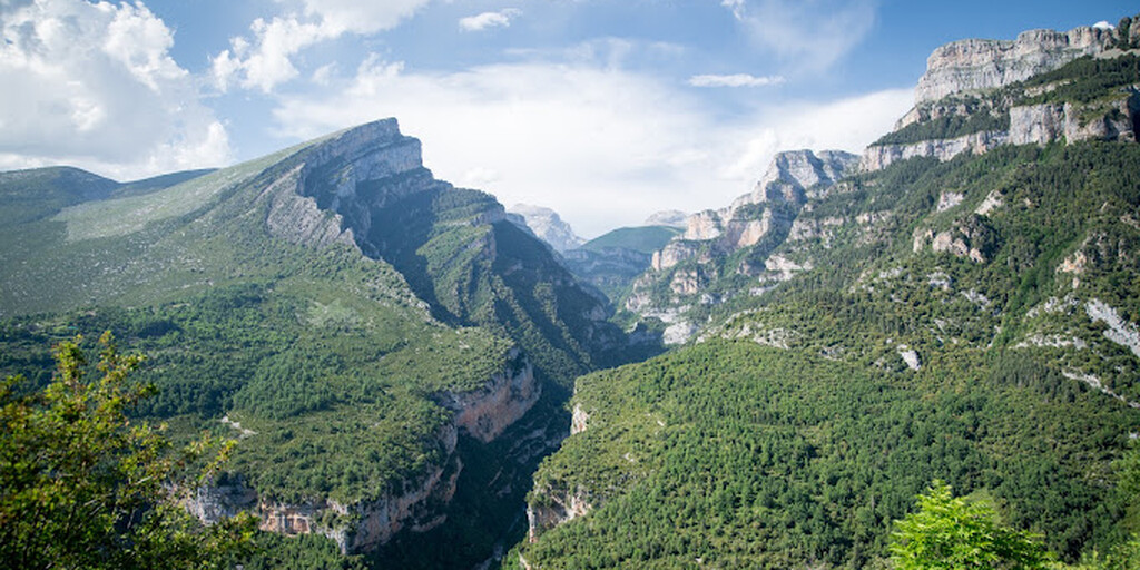
The next 15 kilometers are probably the least beautiful of the 305 kilometers in total. Fortunately, after these 15 kilometers your route heads north and the mountains again. The route soon winds wonderfully through the mountain landscape again. At Mirador del Cañón de Añisclo, the viewpoint over the Añisclo Canyon, you have a beautiful view of the gorge. This beautiful gorge is located in the Ordesa y Monte Perdido National Park. This deep gorge was initially defined through a process of glacial erosion, before being further formed by the fluvial erosion of the Bellós River.
After all that natural beauty, it is time for the inner man. 2.5 kilometers away is the picturesque mountain village of Buerba. Here in the village you will find El Fresno Bar, a small bar/restaurant with terrace. Delicious dishes for a fair price.
The Rio Bellós flows into the Rio Cinca, which you cross in Ainsa, one of the few larger towns in the area. There is usually not much left of that river in the summer. After about 30 kilometers on a wide road, the route bends north again. With just over 85km to go, Campo is the next big town. Maybe a good place for that drink before you start the last kilometers. Restaurante Cotiella has a nice terrace overlooking the parking lot.
The route takes you further to the East. When he heads north for the last time you have a chance to see the Pico Aneto. At 3404 meters, Pico Aneto is the highest mountain in the Pyrenees. Just before Vielha you enter the Juan Carlos I tunnel. This is located next to the older tunnel that was the longest tunnel in Europe from 1948 to 1964.
Located in the Vall d'Aran Valley in the Catalan Pyrenees, Vielha is a charming town with a rich history and beautiful natural surroundings. In the Romanesque church of Sant Miquèu, la Iglesia de San Miquèu de Vielha, in the center of the city you will find a beautiful 12th century crucifix called Cristo de Mijaran. With so many tourists and multiple hotels, the restaurant options are endless. Restaurant Era Coquela is an excellent and not too expensive Spanish restaurant. Booking in time is wise.

 Links
Links  Usage
Usage Want to download this route?
You can download the route for free without MyRoute-app account. To do so, open the route and click 'save as'. Want to edit this route?
No problem, start by opening the route. Follow the tutorial and create your personal MyRoute-app account. After registration, your trial starts automatically.  Disclaimer
Use of this GPS route is at your own expense and risk. The route has been carefully composed and checked by a MyRoute-app accredited RouteXpert for use on TomTom, Garmin and MyRoute-app Navigation.
Changes may nevertheless have occurred due to changed circumstances, road diversions or seasonal closures. We therefore recommend checking each route before use.
Preferably use the route track in your navigation system. More information about the use of MyRoute-app can be found on the website under 'Community' or 'Academy'.

Navarre
About this region
Navarre (English: ; Spanish: Navarra [naˈβara]; Basque: Nafarroa [nafaro.a]), officially the Chartered Community of Navarre (Spanish: Comunidad Foral de Navarra [komuniˈðað foˈɾal de naˈβara]; Basque: Nafarroako Foru Komunitatea [nafaro.ako foɾu komunitate.a]), is an autonomous community and province in northern Spain, bordering the Basque Autonomous Community, La Rioja, and Aragon in Spain and Nouvelle-Aquitaine in France. The capital city is Pamplona (or Iruñea in Basque). The present-day province makes up the majority of the territory of the medieval Kingdom of Navarre, a long-standing Pyrenean kingdom that occupied lands on both sides of the western Pyrenees, with its northernmost part, Lower Navarre, located in the southwest corner of France.
Navarre is in the transition zone between Green Spain and semi-arid interior areas, and thus its landscapes vary widely across the region. Being in a transition zone also produces a highly variable climate, with summers that are a mix of cooler spells and heat waves, and winters that are mild fir the latitude. Navarre is one of the historic Basque districts: its Basque features are conspicuous in the north, but virtually absent on the southern fringes. The best-known event in Navarre is the annual San Fermín festival held in Pamplona in July.
Read more on Wikipedia
Navarre is in the transition zone between Green Spain and semi-arid interior areas, and thus its landscapes vary widely across the region. Being in a transition zone also produces a highly variable climate, with summers that are a mix of cooler spells and heat waves, and winters that are mild fir the latitude. Navarre is one of the historic Basque districts: its Basque features are conspicuous in the north, but virtually absent on the southern fringes. The best-known event in Navarre is the annual San Fermín festival held in Pamplona in July.
View region
 Statistics
  9
9Amount of RX reviews (Navarre)
 26281
26281Amount of visitors (Navarre)
 389
389Amount of downloads (Navarre)
 Route Collections in this region
 Pyrenees from West to East
The Spanish Pyrenees are a majestic mountain region in the north of Spain, stretching along the border with France. This enchanting landscape offers a rich mix of natural beauty, historic towns and adventure opportunities.
This collection of 4 routes makes a complete route from Biarritz over the northernmost paved roads in the Spanish Pyrenees, with small side trips into France, to Cap de Creus. The viewpoint on Monte Jaizkibel, the westernmost point, where you have a view of the Bay of Biscay, is the starting point of this trip. The routes are divided into day routes. So a route every day.
The end point is Cap de Creus, the easternmost point of mainland Spain. The last route offers space to drive to your overnight stay in peace and quiet after the last route point.
Use the collection as you wish. Drive from West to East or use the individual routes as an idea for your own Pyrenees adventure.
View Route Collection
Santander to Roscoff via Picos de Europa Pyrenees West coast of France
A tour with 9 routes that all link up, starting from the ferry port of Santander to Potes using lots of twisty roads. The next route is a truly memorable round tour from Potes of the ever popular Picos de Europa. Then the tour heads south and east past reservoirs and picking up the mighty Ebro river and follow it to Miranda de Ebro. Route 4 carries on east towards the Pyrenees with more twisty roads to the destination of Sos del Rey Catolico, a fantastic fortified hilltop village. The next route takes you over the Pyrenees with the chance of a cable car ride up a mountain for lunch. Route 6 is the first day in France and it is a pleasant ride past fields of sunflowers and maize, pine forests and through the Landes de Gascogne Regional Natural Park. Then you cross over the mighty Gironde estuary by ferry and head to the finish at the popular costal town of La Rochelle. We stayed for two night in La Rochelle to sample the delights of this delightful town. Route 7 hugs the coast as it travels north and then crosses the mighty Loire river for a night in Saint Nazaire. Route 8 starts off with a visit to the U boat submarine pens in Saint Nazaire, then through the salt production 'fields' of Guerande and onto Concarneau, another historic walled city that must be visited. The final route takes you to Pointe du Raz then onto Locronan, a medieval village listed as one of the most beautiful villages of France. Then it travels over the Térénez bridge, the world's first curved cable-stayed bridge. Then you enter and travel through the Armorique Regional Natural Park to spend the night at a B&B hotel in Morlaix ready for a short ride in the morning to catch the ferry at Roscoff.
View Route Collection