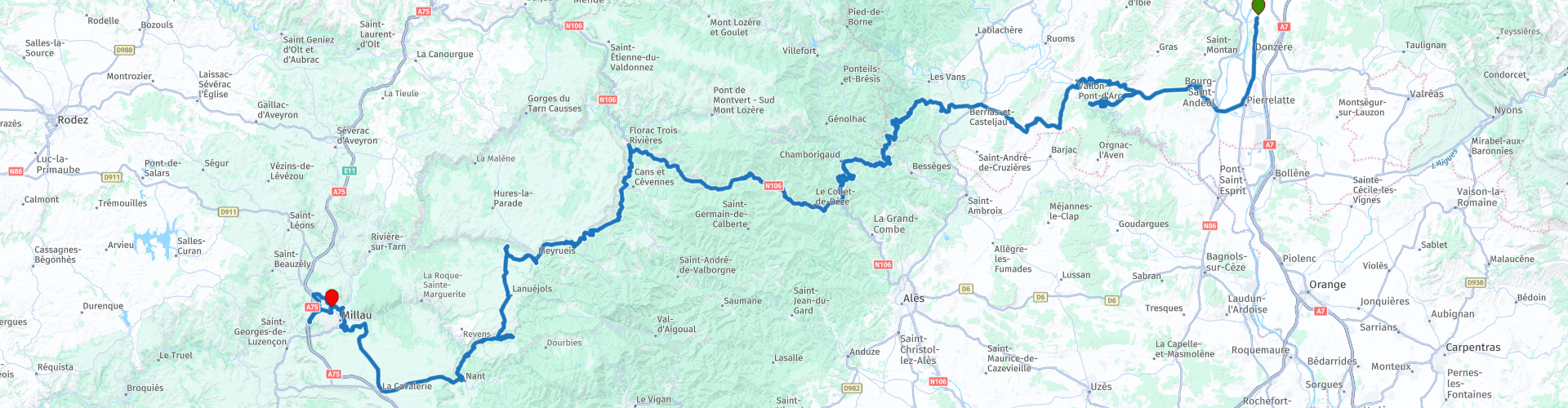
Montelimar Millau

This route was brought to you by:
RouteXpert Aendu Lenz
Last edit: 11-07-2025
 Route Summary
 Highlights:
- Pont d'Arc
- Dargilan Cave
- d'Ardèche
Vehicle/Rider: Motorcycle. Despite the many curves, the route is mostly fast-paced. Due to some challenging curves and the length of the route, it's not suitable for beginners.
This route deserves a star rating of 3-4:
Most roads are quiet, there are beautiful views, places worth seeing, wonderful landscapes and buildings.
 Share this route


Animation

Verdict


Duration
9h 20m

Mode of travel
Car or motorcycle

Distance
313.40 km

Countries

 RouteXpert Review
 (Avoid the Millau region on the last Saturday in September, read below; under “Millau”)
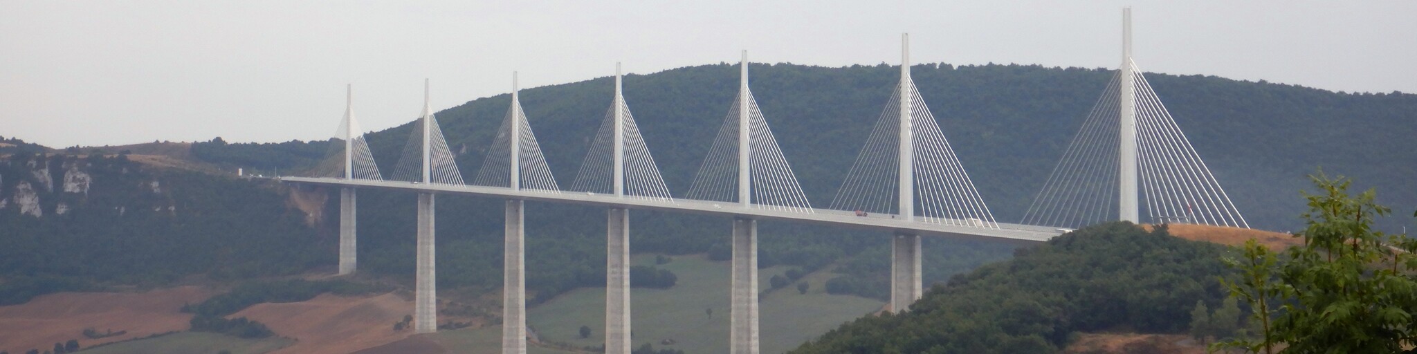
This route begins in Montélimar, a very central location with motorway access. It ends in Millau, home to the gigantic and imposing Millau motorway viaduct.
---"Millau Viaduct"---
Construction of this bridge began in 2001. It cost 400 million euros. It is 2,460 meters long and, at its highest point, 270 meters above ground. The rest area houses an information center about the bridge's construction and a sales pavilion. These buildings are also accessible from the main road.
The starting point is near Montélimar in Châeauneuf-du-Rhone. I chose this starting point for the following reasons: It's not directly in the center, but still easily accessible from the highway. It has a gas station and a shop, so you can stock up on drinks and provisions here. We mostly ride on smaller roads, as we don't always have the opportunity to buy things.
I chose the end point on the elevated northern edge of Millau. There are several hotels and restaurants here, as well as shops and gas stations.
Let's start our journey.
With a full tank and stocked up on drinks, we leave Châeauneuf-du-Rhone heading south toward Pierrelatte. Here, we turn left and drive almost exclusively on departmental roads.
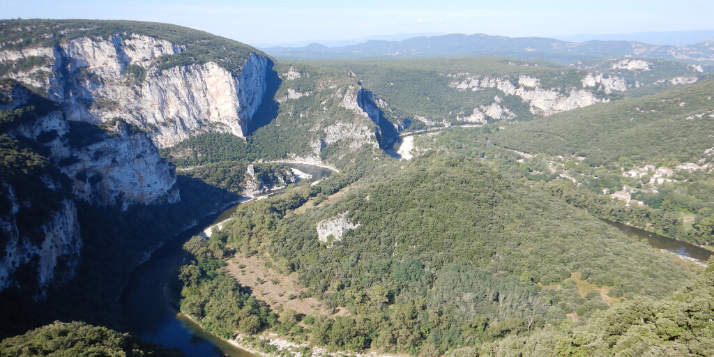
We soon reach the first highlight: the Pont d'Arc. We still have about 300 meters to walk to get there. This short walk relieves us from sitting for so long. I highly recommend it so you can photograph the Pont d'Arc. Right from the parking lot, we have a very, very beautiful view of the Ardéche and can see far into the distance.
--"Pont d'Arc"---
This is a geological rarity. This arch was formed by the Ardéche River, which "bored" through this rock. It is at least 500,000 years old, 54 meters high, and 60 meters wide.
We now continue towards Vallon Pont d'Arc. Here, you could already visit a prehistoric cave. This visit is not included in the itinerary, but it is certainly worth a visit. To get there, turn right just before Vallon Pont d'Arc and follow the sign for "Grotte Chauvet" for 6 kilometers.
We continue towards Vagans, where we turn right (onto the D255 and the other roads D202, D251, D216, D52, D256B, D156, and D17). We continue along narrow roads towards Peyremale. We now follow the Ardèche River again, but unfortunately we can only see it occasionally, as trees block the view. We continue along the D29, D906, D52, and D276. Enjoy the winding roads to Sainte-Cecile-d'Andorge.
Also located here is the TAC – "Train de l'Andorge en Cévennes Francéson." This is an open-top miniature train that you can ride on. To learn more, please visit the website. Search for "Tacletrain" in the search engine.
Continue along the N107 to Florac, where you can stop for a bite to eat at one of the restaurants. If necessary, you can also refuel.
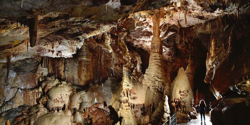
We then continue on the D907 and D906 to Meyrueis, enjoying the winding roads. Shortly afterward, we leave this road and take the D139 to the Darglian Cave, where we visit it.
--"Grotte de Darglian" --
UNESCO World Heritage Site. An underground labyrinth. Discovered by Edouard Alfred Martel in 1888, it was opened to the public in 1890. It is impressive in its size and colorful accents.
--"Millau"—
The 100-kilometer race has been held on the last Saturday in September since 1972. I recommend you avoid traveling in the Millau region on this date. (I speak from personal experience. Long wait times, long detours.)
Afterwards, we'll head to Millau, where we'll first drive to the viaduct. Here, we'll have the opportunity to visit the museum dedicated to the viaduct's construction. Afterwards, we'll drive to the northern part of Millau, where we'll check into a hotel to reflect on the beautiful day and let the day come to a close.
 Links
Links  Usage
Usage Want to download this route?
You can download the route for free without MyRoute-app account. To do so, open the route and click 'save as'. Want to edit this route?
No problem, start by opening the route. Follow the tutorial and create your personal MyRoute-app account. After registration, your trial starts automatically.  Disclaimer
Use of this GPS route is at your own expense and risk. The route has been carefully composed and checked by a MyRoute-app accredited RouteXpert for use on TomTom, Garmin and MyRoute-app Navigation.
Changes may nevertheless have occurred due to changed circumstances, road diversions or seasonal closures. We therefore recommend checking each route before use.
Preferably use the route track in your navigation system. More information about the use of MyRoute-app can be found on the website under 'Community' or 'Academy'.

Occitanie
About this region
Occitanie (French pronunciation: [ɔksitani] (listen); Occitan: Occitània [utsiˈtanjɔ]; Catalan: Occitània [uksiˈtaniə]), Occitany or Occitania (), is the southernmost administrative region of metropolitan France excluding Corsica, created on 1 January 2016 from the former regions of Languedoc-Roussillon and Midi-Pyrénées. The Council of State approved Occitanie as the new name of the region on 28 September 2016, coming into effect on 30 September 2016.The modern administrative region is named after the larger cultural and historical region of Occitania, which corresponds with the southern third of France. The region Occitanie as it is today covers a territory similar to that ruled by the Counts of Toulouse in the 12th and 13th centuries. The banner of arms of the Counts of Toulouse, known colloquially as the Occitan cross, is used by the modern region and is also a popular cultural symbol. In 2015, Occitanie had a population of 5,839,867.
Read more on Wikipedia
View region
 Statistics
  81
81Amount of RX reviews (Occitanie)
 30433
30433Amount of visitors (Occitanie)
 4255
4255Amount of downloads (Occitanie)
 Route Collections in this region
 25 Magnificent trails in France
This MRA route collection contains 25 beautiful motorcycle routes in different parts of France, such as the Ardennes, the Alsace, Vercors, the Drôme, the Ardèche, Cote d'Azure, Gorges du Verdon, the Ariège, the Dordogne and Brittany.
The routes have been carefully created by Bert Loorbach, who is an enthusiastic motorcyclist himself. He lived in France for a year and a half, during which time he devoted himself to mapping the unknown and beautiful back roads of France especially for motorcyclists.
The routes are bundled in the Motortourgids France part 1 of Kosmos publishing house and now also available in MyRouteApp.
I have taken over the routes in MRA and sometimes adjusted them slightly to make them even more interesting for the motorcyclist.
View Route Collection
24 Magnificent trails in France
It is clear that France is one of the most beautiful and best touring countries. It offers an incredibly varied landscape with good roads and a pleasant climate. It is not for nothing that you see so many motorcyclists there. My previous collection of 25 routes in France (25 Magnificent routes in France) were based on the route descriptions from the Motortourgids France part 1 made by Bert Loorbach.
This collection of 24 routes comes from Motortourgids France part 2. In this collection, a difference has been made between approach routes and motorcycle tours in a certain area. The approach routes can also be used in combination with the routes from Motortourgids France part 1
The routes are sometimes slightly adjusted based on the tips that Bert Loorbach gives in his description, or because of another place to spend the night, or to reach the minimum length of 2 hours for the MRA Library. For each route, the review contains a more detailed description, including options to stay overnight or places of interest along the way, which are also indicated with a POI and if possible with a short description.
Two or more routes have been created for a number of areas, such as for Burgundy, Auvergne, The Alps, Tarn and Cévennes and Nord-Pas de Calais. These routes can be nicely combined in a multi-day trip.
View Route Collection