TTT 2024 05 Vierlingsbeek Berg en Terblijt

This route was brought to you by:
RouteXpert Hans van de Ven (Mr.MRA)
Last edit: 30-11-2024
 Route Summary
 These TTT are tours through the Netherlands with an occasional excursion to Belgium, Germany or even Luxembourg, which are held 6 to 7 times a year. These TTT have a starting point, a rest stop and an end point. It is fun to discover what you have not yet seen in your own country and which nice roads you did not know yet.
This TTT may differ slightly from the original.
Thanks to Motor.nl & Jos
This 4-star rated route is always fun to drive and shows you a beautiful part of the Netherlands!
Route Optimization: Fastest.
 Share this route


Animation

Verdict


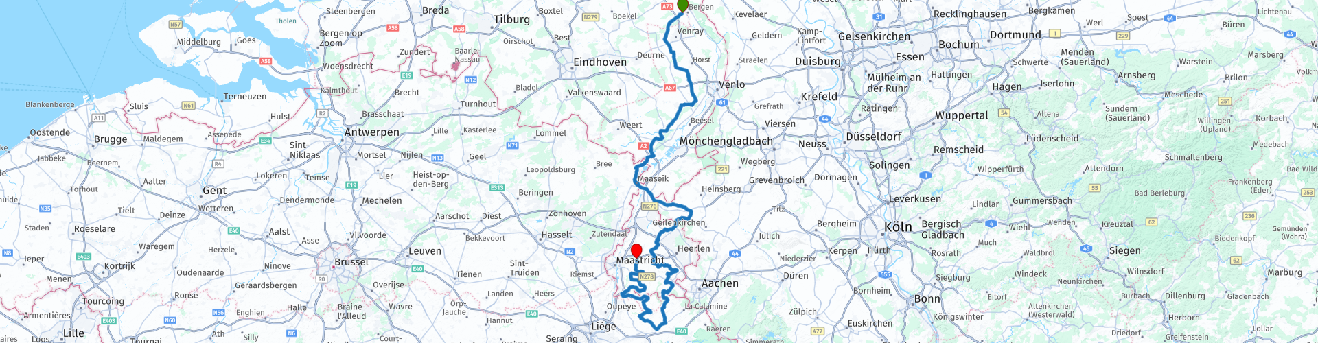
Duration
8h 44m

Mode of travel
Car or motorcycle

Distance
255.15 km

Countries


 RouteXpert Review
 In doing so, he always manages to avoid traffic jams and through roads. So we cross the A73 via the Vierlingsbeekseweg and arrive in Overloon. 'War belongs in the museum' is the motto of the War Museum, which focuses primarily on the history of the Second World War in the Netherlands. The former battlefield of Overloon is home to the largest and oldest war museum on the Second World War in Western Europe. Some 20,000 m² of war history, including more than 180 military vehicles. Unfortunately, the museum motto is not true everywhere outside our national borders. Chapels and crosses can be found along the road in Limburg. Limburg has been Catholic since Roman times. But the iconoclasm and religious wars that ravaged the rest of the Netherlands passed Limburg by. The Second World War also largely passed the village of Merselo by and out of gratitude for that, the people of Merselo built the beautiful Maria chapel that our route passes. Maria is not only depicted here as the mother of Jesus, but as the queen of all people. She stands on a hemisphere representing the world and with her foot she tramples a snake, the symbol of evil.
Via Merselo you drive to America, which is a short distance on a Limburg and Dutch scale. The place name sign says '”hoije wa!', which means 'see you later!' Also in terms of language, Limburg has different
borders are never far away. The local dialects connect all the surrounding areas, with influences from French and German. Helden follows America. On the Molenweg there is a beautiful building complex that you would rather place in the French Versailles or the German Potsdam, such a beautiful palace castle it is. Via coffee with Limburg pie at Dennenoord in Roggel you arrive in Grathem.
Hey, you probably know that inn! Back in the nineties of the last century, restaurant-café-hall Geraats already appeared on a route that Jos had mapped out. At this home base of MC Grathem, five different motorcycle routes are ready for enthusiasts, on Sundays from May to September. Free of charge! 'Drive safely, discover the world, help each other and make motorcycle friends', is the motto of this friendly Limburg motorcycle club. On the first tour with Jos, quite a few routes were followed, but Jos always manages to surprise with unknown winding roads that make the motorcyclist's heart beat faster. With a clever balance between steering fun, natural beauty and sights along the way.
Parallel to the Maas winding here, you drive via Thorn with its beautiful white houses out of the Netherlands and into Belgium. If Maaseik is still on Belgian soil, in Maasheuvel you are already on Dutch asphalt. Is there an accident
been on that Pater Sangers bridge over the Maas? The railing looks distorted. But no: it is a work of art, called 'Connection between the two Limburgs', something with two pairs of hands holding on to a rope with a
tie a knot in it. Very symbolic, connection instead of separation, across the border, which runs in the middle of the Maas. Jos: 'I like to include parts of Belgium and Germany in my route. Because there
can you at least drive a little further.' Borders? Don't tell the inhabitants of Selfkant anything about borders. From 1949, Selfkant was Dutch territory for fourteen years. But after Germany had dutifully paid the reparations, they got the village back in 1963. At Selfkant, a boulder marks the border between Germany and the Netherlands, as well as the westernmost point of the FRG, according to the text chiselled on this Grenzstein 309B. Despite all the border complications, the good relations between Selfkant and the Maasland continue to exist. The common dialect still connects the inhabitants. Since 1989, the toll booths have been closed and the borders open, but here in Selfkant that doesn't really make any difference. From Selfkant, the narrowest part of the Netherlands, barely five kilometers as the crow flies, runs to the Belgian border at Dilsen-Stokkem. And the German Selfkant has another surprise in store, expertly woven into our route by Jos. Historic steam locomotives and wagons are lovingly restored and waiting for passengers at the little station of Schierwaldenrath. We swing after a short break further over German avenues to Gangelt, where you enter the Netherlands again. You meander past Valkenburg and Simpelveld over narrow and steep roads.
Unlikely that this is in the Netherlands, but it is. Then via a gray border post back into Belgium, past the castle of Sippenaeken. HenriChapelle, Thimister-Clermont, that clearly sounds like
Wallonia.
The Voer region is also marked by the Belgian language border: on bilingual place name signs, opponents of Flemish or Walloon names have traditionally made the letters illegible with paint.
the N608 it is Flemish all over again. Planck, Einde, Schoppen, Schietekamer and Grijzegraaf glide past on the GPS, then you cross the dotted line that welcomes us back to the Netherlands. The corn in the
fields stands tall as bushes in a tropical jungle. Jos: 'You can actually drive a route like this at least four times a year. At least. The landscape looks completely different in every season.'
Formerly with a router roll, now with GPS. The landscape through which Jos leads seems to have changed little in the past 25 years. But two thousand years ago, there were hundreds of Roman villas in Limburg: enormous estates in Mediterranean style, with houses equipped with glass windows and underfloor heating, bathhouses, storage spaces, stables, workshops, ornamental gardens and large arable lands. The Limburg villas provided all residents in the region with
grain. They lived in cities such as Heerlen, Cuijk, Xanten and Cologne. The soldiers along the limes, the northern border of the Roman Empire, were also customers. Grain was traded to the furthest corners of north-west Europe. This happened via the extensive network of Roman (water)ways. When Roman power declined at the end of the third century, the villas were destroyed, burned down and abandoned. Nowadays, there is almost nothing left to see in the Limburg landscape.
We drive around Maastricht in an arc. Maastricht is internationally known for its pleasant terraces on the Vrijthof and the concerts of André Rieu. But in 1673 the city was on the map differently than the French
King Louis XIV, also known as the Sun King, carried with him. A drawing by Adam Frans van der Meulen, the campaign painter of the French court, has been preserved. It shows clouds of smoke, trenches and hundreds of soldiers. Behind it beckoned the stronghold of the Netherlands: the city of Maastricht. The siege of Maastricht, personally led by the French king, lasted thirteen days. On 30 June 1673 the city surrendered. One of the
strongest fortresses of Europe fell into French hands. Germans, Romans and French have disappeared from Limburg. What remains are the pristine winding roads that Jos Bosch always manages to capture in a new tour.
At the Geulhemermolen in Berg en Terblijt another memorable motorcycle ride comes to an end. Thanks Jos, see you next time.


 Links
Links  Usage
Usage Want to download this route?
You can download the route for free without MyRoute-app account. To do so, open the route and click 'save as'. Want to edit this route?
No problem, start by opening the route. Follow the tutorial and create your personal MyRoute-app account. After registration, your trial starts automatically.  Disclaimer
Use of this GPS route is at your own expense and risk. The route has been carefully composed and checked by a MyRoute-app accredited RouteXpert for use on TomTom, Garmin and MyRoute-app Navigation.
Changes may nevertheless have occurred due to changed circumstances, road diversions or seasonal closures. We therefore recommend checking each route before use.
Preferably use the route track in your navigation system. More information about the use of MyRoute-app can be found on the website under 'Community' or 'Academy'.

Limburg
About this region
Limburg (Dutch pronunciation: [ˈlɪmbʏr(ə)x] (About this soundlisten)) is the southernmost of the 12 provinces of the Netherlands. The province is bordered by the province of Gelderland to the north and by North Brabant to its west. Its long eastern boundary forms the international border with the state of North Rhine-Westphalia in Germany. To the west is the international border with the similarly named Belgian province of Limburg, part of which is delineated by the river Meuse. The Vaalserberg is on the extreme south-eastern point, marking the tripoint of the Netherlands, Germany and Belgium.
Limburg's major cities are the provincial capital Maastricht (pop. 121,565[5]), as well as Venlo (pop. 101,603) in the Northeast, and Sittard-Geleen (pop. 92,661) and Heerlen (pop. 86,832) in the south. More than half of the population, approximately 650,000 people, live in the south of Limburg, which corresponds to roughly one-third of the province's area proper. In South Limburg, most people live in the urban agglomerations of Maastricht, Parkstad and Sittard-Geleen.
Read more on Wikipedia
Limburg's major cities are the provincial capital Maastricht (pop. 121,565[5]), as well as Venlo (pop. 101,603) in the Northeast, and Sittard-Geleen (pop. 92,661) and Heerlen (pop. 86,832) in the south. More than half of the population, approximately 650,000 people, live in the south of Limburg, which corresponds to roughly one-third of the province's area proper. In South Limburg, most people live in the urban agglomerations of Maastricht, Parkstad and Sittard-Geleen.
View region
 Statistics
  100
100Amount of RX reviews (Limburg)
 73589
73589Amount of visitors (Limburg)
 27105
27105Amount of downloads (Limburg)
 Route Collections in this region
 The 10 most beautiful car and motorcycle routes in North Brabant
Brabant, Brabant conviviality, bon vivants and who does not know the song by Guus Meeuwis about Brabant? "And then I think of Brabant, because there is still light burning there" and that is true, because the City of Light is in Brabant, in Eindhoven that is, but Eindhoven is also known as the match city of the Netherlands. The annual light festival (GLOW) in Eindhoven shows breathtaking lighting techniques, something you must see once.
But not only light, matches and Brabant cosiness in Brabant, but also a very beautiful province to tour by car or motorcycle and enjoy all the beauty that the province of Brabant has to offer. For this, the MyRoute app RouteXpert has put together a Top 10 of Car and Motorcycle routes for you.
All routes in this collection have been checked and made equal for TomTom, Garmin and MyRoute-app Navigation by a MyRoute-app RouteXpert.
If you think, I have a very nice route that should certainly not be missing from this collection, send it to:
email: routeexpert@myrouteapp.com
Subject: New Route for the Top 10 collection Province of Brabant composed by Hans van de Ven.
The route will then be reviewed and then added to the Top 10.
To make the Top 10 also the Top 10, 1 route will have to disappear from the Top 10, you can indicate this when submitting the new route.
Have fun with this collection and while driving one of these routes. Enjoy all the beauty that the Netherlands and in particular the province of Brabant has to offer. Click on “View route” to read the review of the chosen route.
I would like to hear your findings about the route(s).
View Route Collection
The 10 most beautiful car and motorcycle routes in Limburg
Limburg, who thinks of Limburg, thinks of flan, coal mines, marl and the hill country. The coal mines have been closed for almost 40 years, the last load of coal was brought up from the Oranje-Nassau coal mine in Heerlen on 31 December and, as they say, South Limburg was transformed from Black to Green and unfortunately there is still little left. view of this period.
But not only pie, marl and coal in Limburg, but also a very beautiful province to tour by car or motorcycle and enjoy all the beauty that the province of Limburg has to offer. For this, the MyRoute app RouteXpert has put together a Top 10 of Car and Motorcycle routes for you.
All routes in this collection have been checked and made equal for TomTom, Garmin and MyRoute-app Navigation by a MyRoute-app RouteXpert.
If you think, I have a very nice route that should certainly not be missing from this collection, send it to:
email: routeexpert@myrouteapp.com
Subject: New Route for the Top 10 collection Province of Limburg composed by Hans van de Ven.
The route will then be reviewed and then added to the Top 10.
To make the Top 10 also the Top 10, 1 route will have to disappear from the Top 10, you can indicate this when submitting the new route.
Have fun with this collection and while driving one of these routes. Enjoy all the beauty that the Netherlands and in particular the province of Limburg has to offer. Click on “View route” to read the review of the chosen route.
I would like to hear your findings about the route(s).
View Route Collection