Rundfahrt ab Rapperswil ueber kleine Innerschweizer Paesse und mit Schweizer Geschichte

This route was brought to you by:
RouteXpert David Ruprecht
Last edit: 09-09-2024
 Route Summary
 I give the tour five stars because there are hardly any more varied routes with so little traffic.
Basically, the tour is more for experienced drivers. Shortly after the Etzel Pass, there is a short, very undulating stretch of unpaved road. This section, as well as the Etzel and Pragel passes, require great attention and good control of the vehicle.
Attention: The Pragel Pass is only accessible on weekdays; on weekends and public holidays the route from the top of the pass down to the Klöntalersee is closed.
 Share this route


Animation

Verdict


Duration
9h 39m

Mode of travel
Car or motorcycle

Distance
210.89 km

Countries

 RouteXpert Review
 I give the tour five stars because there are hardly any more varied routes with so little traffic.
Basically, the tour is more for experienced drivers. Shortly after the Etzel Pass, there is a short, very undulating stretch of unpaved road. This section, as well as the Etzel and Pragel passes, require great attention and good control of the vehicle.
Attention: The Pragel Pass is only accessible on weekdays; on weekends and public holidays the route from the top of the pass down to the Klöntalersee is closed.
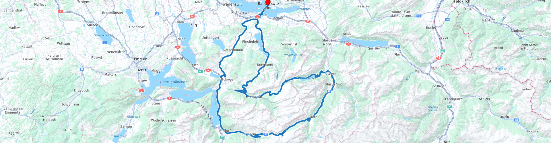
We start at Rapperswil train station and immediately cross the lake over the lake dam. On the right, there is a beautiful view over Lake Zurich towards Zurich, on the left the unspoiled Obersee towards Lachen. We drive through the village of Pfäffikon and quickly climb up to the Etzel Pass. With a magnificent view of the two Mythen (two very well-known mountains straight ahead) and over Lake Sihl, we go down, through the historic stone bridge and then left towards the lake. We drive carefully and slowly along the 300m unpaved road. The road then leads through gentle curves along Lake Sihl, where we then turn left towards Euthal at the second bridge over the lake. Be careful: there is a police radar box at the end of the village.
At the end of Lake Sihl we cross the valley between Studen and Unteriberg, which is popular with cross-country skiers. In Unteriberg we turn right and drive up to Oberiberg, a very popular ski resort. We cross the village and drive up the pass road to Ibergeregg. At the top of the pass we take a well-deserved coffee break.
We only drive about halfway down the pass road towards Schwyz, where we turn left and drive through cow pastures and alpine farms to Illgau. This part of the route is hardly used and is simply beautiful.
From Illgau we drive down into the Muotathal and turn left to get to the very end of the valley. If you have the time and inclination, we recommend visiting the world-famous "Höllloch" caves in Stalden, but it takes a lot of time and good hiking boots, as well as rain gear and a sweater. We drive past them up towards the Pragel Pass. The narrow pass road winds through rocks, forests and meadows. Crossing is only possible with caution, so it is important to adjust your speed accordingly.
At the top of the pass, we take our time to enjoy the view before we head down towards Lake Klöntal. Even on the way down, this unspoiled and pristine lake looks like a Norwegian fjord or something from the film "The Lord of the Rings". Simply wonderful. The route is limited to 40 km/h, so you can enjoy the ride and the view. The road runs along the lake over countless bends on the somewhat bumpy road to the dam, which we cross. Then we turn left up towards Schwammhöhe and Glarus. When we reach the high valley, we turn left towards Schwammhöhe and drive along the one-way road to the Schwammhöhe restaurant, where a unique view of Lake Klöhntal awaits. Here we enjoy a delicious lunch and the peace and quiet of the mountains.
Strengthened in this way, we take the road down to Glarus. We turn left in the high valley and take the quiet back road down to Glarus. This is a great relief, especially on hot days, as most of the route is through the forest and therefore in the shade. In Glarus, the smallest capital in the world, we turn right towards the Klausen Pass. We cross almost the entire canton of Glarus until we reach the pass road in Linthal. A small section of a few hundred meters at the beginning still has the original Klopfstein paving. Be careful when it's wet, these stones are very slippery. Then it goes up, over beautiful curves, through short tunnels and over long straights to Urnerboden, another high valley. We don't cross this too quickly, as the road has very large bumps in places.
And then, finally, we head up the famous pass road with its serpentines to the Klausen Pass. A photo with the view over the Urnerboden is a must. At the top of the pass we allow ourselves another coffee break, we deserve it.
The descent is also a pleasure with its many curves and straights and we soon arrive in Altdorf, the birthplace of our national hero William Tell. Here we recommend a historical sightseeing tour: either with the Tell Museum in Bürglen or with the Tell monument, the so-called Türmli, in Altdorf and the Uri Historical Museum. There you can also see an original stagecoach that used to travel over the Klausen Pass. Or for those interested in religion there is the Church Treasure Museum. After visiting the museum we fortify ourselves with a refreshing drink in a restaurant and then tackle the final part of the route.
First, the route takes us along the notorious Axenstrasse, which has to be closed from time to time due to falling rocks. The view of the lake is always very beautiful, even through the pillars of the protective galleries. At the end, we take a short stretch of motorway (note: don't forget the vignette!) and leave it after just a few kilometers in Schwyz. We drive over the "Sattel" (the name of the village and the crossing) to Rothenthurm, where one of the most beautiful raised bogs in Switzerland is located to our left. A walk through this plain is also highly recommended.
We continue on to Sihlbrugg and Schindellegi, but just before Pfäffikon we take a small detour via Feusisberg and have a great view over the lake, Rapperswil, the Pfannenstiel and the Zurich Oberland. In the forest we come across the route that we drove up in the morning, namely the road to the Etzel Pass. This time we only drive the short stretch down to Pfäffikon, fill up with petrol and then return to Rapperswil via the lake dam.


 Links
Links  Usage
Usage Want to download this route?
You can download the route for free without MyRoute-app account. To do so, open the route and click 'save as'. Want to edit this route?
No problem, start by opening the route. Follow the tutorial and create your personal MyRoute-app account. After registration, your trial starts automatically.  Disclaimer
Use of this GPS route is at your own expense and risk. The route has been carefully composed and checked by a MyRoute-app accredited RouteXpert for use on TomTom, Garmin and MyRoute-app Navigation.
Changes may nevertheless have occurred due to changed circumstances, road diversions or seasonal closures. We therefore recommend checking each route before use.
Preferably use the route track in your navigation system. More information about the use of MyRoute-app can be found on the website under 'Community' or 'Academy'.

Schwyz
About this region
The canton of Schwyz (German: Kanton Schwyz [ʃviːts] (listen)) is a canton in central Switzerland between the Alps in the south, Lake Lucerne to the west and Lake Zürich in the north, centered on and named after the town of Schwyz.
It is one of the founding cantons of Switzerland; Switzerland's name is derived from the name of the canton, and the flag of Switzerland from its coat of arms. For the history of the name, see Schwyz. The Swiss Federal Charter is on display in Schwyz. Northeast of the town of Schwyz is Einsiedeln Abbey.
Read more on Wikipedia
It is one of the founding cantons of Switzerland; Switzerland's name is derived from the name of the canton, and the flag of Switzerland from its coat of arms. For the history of the name, see Schwyz. The Swiss Federal Charter is on display in Schwyz. Northeast of the town of Schwyz is Einsiedeln Abbey.
View region
 Statistics
  14
14Amount of RX reviews (Schwyz)
 15653
15653Amount of visitors (Schwyz)
 1484
1484Amount of downloads (Schwyz)
 Route Collections in this region
 The 24 Most Beautiful Alpine Routes
The Alps, The Alps are a mountain range in Europe, stretching from the French Mediterranean coast in the southwest to the Pannonian Plain in the east. The area of the mountain range is more than 200,000 km².
In other words Passes and Mountain Roads!
Driving through the mountains is great! Especially over the mountain passes with hairpin bends and narrow winding roads. Every bend a different view where you can enjoy. There are many beautiful mountain passes in the Alps.
A selection that has also been incorporated into these routes:
The Stlevio Pass:
The Stelvio Pass, also known as Passo dello Stelvio, is mainly known for the stage in the Giro d'Italia. Due to the length and the difference in height, this pass is seen as one of the toughest tests in cycling. The Stelvio Pass reaches a maximum height of 2758 meters and is therefore one of the highest in the Alps. The pass connects the towns of Bormio and Prato Allo Stelvio. In winter the pass is closed due to heavy snowfall.
The Reschenpass:
The Reschenpass, also known as Passo di Resia, connects the Austrian state of Tyrol with the Italian province of South Tyrol. The pass reaches a maximum height of 1,504 meters and has been one of the most important north-south connections in the Alps in recent centuries. The pass was used long before Roman times. Along the way you will pass several highlights and historical relics. One of the highlights is the Reschensee. This lake was created after the construction of the dam and has completely submerged the village of Graun. The only thing that reminds of that is the clock tower in the middle of the lake.
Col du Galibier:
The French mountain pass Col du Galibier connects the towns of Saint-Michel-de-Maurienne and Briançon via the Col du Lautaret in the south and the Col du Télégraphe in the north. The mountain pass is part of the Tour de France and very much feared, due to the fact that it can only be reached via the other two mountain passes. The pass reaches a maximum height of 2646 meters. From there you can take a walk to the viewpoint at 2704 meters. You can admire the peaks of the Grand Galibier, Mont Blanc and La Meije here.
The Grossglockner High Alpine Road:
With a height of 3798 meters the Grossglockner is the highest mountain in Austria. To fully enjoy this impressive mountain, you can drive over the Grossglockner High Alpine Road and the accompanying pass. The route starts from Bruck am Grossglockner and ends in Heiligenblut. Of course you can drive in two directions. The pass reaches a maximum height of 2504 meters and is closed in winter due to heavy snowfall. Along the way you pass several stops with fun activities, information points, mountain huts and viewpoints. A visit to the Kaiser-Franz-Josefs-Höhe and Pasterzen Glacier is highly recommended.
The Col d'Izoard:
Just like the Col du Galibier, the Col d'Izoard is also part of a stage of the Tour de France. The mountain pass connects Briançon with the valley of the river Guil. The pass is partly located in the Regional Natural Park du Queyras and reaches a maximum height of 2360 meters. What is special about the Col d'Izoard is the barren and rocky landscape. Sometimes it feels like driving a car over the moon! Along the way you can stop at several points to enjoy the beautiful view.
The Bernina Pass:
The Bernina Express is one of the most famous rail trains in Switzerland and the Alps. The route is beautiful and partly included on the UNESCO World Heritage List. Parallel to the railway lies the Bernina pass, which connects the Veltlin valley with the Egandin valley. This beautiful Alpine road has a total length of 56 kilometers and reaches a maximum height of 2328 meters. Along the way you can enjoy views of the Morteratsch Glacier.
The Sella Pass:
The Sella Pass, also known as Passo di Sella, takes you over one of the most impressive mountain ranges in the Dolomites: the Sella massif. The pass connects Valle di Fassa with Val Gardena and reaches a maximum height of 2236 meters. At this height is also the border of the Italian provinces of Trentino and Bolzano. Along the way you can enjoy the view of this spectacular mountain world. Admire, for example, the three peaks of the Sasso Lungo massif, the Sella massif or the peaks of the Marmolada. You can also drive the Sella pass in combination with the Gardena pass, Pordoi pass and Campolongo pass.
The Grimsel Pass:
The Grimsel Pass connects Goms in Wallis with the Halis Valley in the Bernese Oberland. The pass reaches a maximum elevation of 2165 meters and is closed in winter due to snowfall. Over the centuries, the mountain pass has played an important role in trade between Switzerland and Italy. Now it is mainly the reservoirs that have an important function. These are used to generate electricity. The landscape you drive through is rugged, rocky and impressive. On top of the pass is a hotel and a restaurant with a special marmot park. The Dodensee (Totensee) is also located here. This lake owes its name to the many soldiers who died in the time of Napoleon.
The Gotthard Pass:
The Gotthard Pass, also known as Passo del San Gottardo and Saint Gotthard, connects the Swiss towns of Airolo and Andermatt. The mountain pass and associated tunnel are especially known among holidaymakers driving from Switzerland to Italy. But where the majority opt for the tunnel, it is precisely the pass that really completes the holiday. The Gotthard Pass has a length of about 26 kilometers and reaches a maximum height of 2106 meters. The route is beautiful and takes you along old villages and beautiful views.
The Silvretta High Alpine Road and Silvretta Pass:
The Paznaun Valley in Tyrol and the Montafon in Vorarlberg are connected by the Silvretta High Alpine Road. The route has a length of 22.3 kilometers and leads from Galtür to Partenen in 34 hairpin bends, via the 2032 meter high Bielerhöhe. The Silvrettasee is also located at this point, where you can enjoy a lovely walk. The pass is closed in winter due to snowfall.
The Simplon Pass:
Just like the Gotthard Pass, many holidaymakers also travel over the Simplon Pass every year. This mountain pass connects the Rhone Valley in the canton of Valais with the Valle d'Ossola in Piemonte. The pass is open all year round and reaches a maximum height of 2005 meters. Along the way you pass a number of buildings, including the well-known Simplon Hospiz from 1825. The hospiz is managed by the monks of St. Bernard. From the highest point on the pass, all kinds of hiking routes are possible and you will also come across a hotel where you can spend the night.
The Gerlos Pass:
The Gerlos Pass connects the Salzach Valley in the Salzburgerland with the Zillertal Valley in Tyrol. The pass is part of the Gerlos Alpenstraße and runs right through the Hohe Tauern National Park. Along the way you can enjoy beautiful views of the surroundings. The pass has a length of 12 kilometers and reaches a maximum height of 1531 meters. A ride over the Gerlos Pass can be ideally combined with a visit to the Krimmler Wasserfälle.
The Great St. Bernard Pass:
The Great St. Bernard Pass, better known as Col du Grand Saint Bernard, connects the Italian province of Valle d'Aosta with the Swiss canton of Valais. The pass is one of the highest in Switzerland and reaches a maximum height of 2469 meters. Like a number of other mountain passes in this list, the Great St. Bernard Pass has also been used as a connecting road for centuries. The pass is named after the St. Bernard dogs that used to help stranded travelers along with the monks. The pass is closed in winter.
The Timmelsjoch High Alpine Road:
The Timmelsjoch High Alpine Road connects the towns of Sölden in the Ötztal and Meran in South Tyrol. Tolls must be paid on the Hochgurgl - Moos route. Via a mountain road with about 60 hairpin bends you drive through a beautiful mountain world. With the Timmelsjoch Experience you can learn more about the history, the road and the environment via various stations. You can also visit the Top Mountain Crosspoint museum.
Col de l'Iseran:
With a maximum pass height of 2770 meters, the Col l'Iséran is one of the highest mountain passes in the Alps. The pass connects Bourg-Saint-Maurice with Bonneval-sur-Arc. Via a road full of hairpin bends you pass, among other things, Val-d'Isère and a side valley of the Maurienne that lies entirely in the National Park de la Vanoise. You can spot animals such as marmots and chamois and there is also a restaurant with a chapel on top of the pass.
The Gavia Pass:
The Gavia Pass (Italian Passo di Gavia) is a mountain pass in the Italian Alps, in the Lombardy region.
It is one of the highest pass roads in Europe. The road leads through the unspoilt Stelvio National Park. The road was built in the First World War to supply Italian soldiers who fought in the Italian-Austrian border area. The pass height is one of the most beautiful in the Alps. Here is the large Lago Bianco with, to the north, the mountain San Matteo (3684 meters). Lago Nero is slightly lower on the south side of the pass. Here the mountain group of the Adamello determines the view. There are many well-marked walks in the area. During the winter the pass is closed due to the heavy snowfall. The pass is often closed until May and June due to the large amount of snow.
Promoter has made a selection of the 24 Most Beautiful Alpine routes that they have set out in recent years.
The routes go through:
France
Austria
Switzerland
Italy
The most beautiful roads, the most beautiful views, the most beautiful viewpoints. The highest mountains, the fastest descents, hairpin bend after hairpin bend, you name it you can't get enough of it.
If you go on holiday in this region, take advantage of it, ALL routes in this collection have been checked and made equal for TomTom, Garmin and MyRoute-app Navigation by a MyRoute-app RouteXpert.
Have fun with this collection and while driving one of these routes. Enjoy all the beauty that the Alps and the Dolomites have to offer. Click on “View route” to read the review of the chosen route.
I would like to hear your findings about the route(s).
View Route Collection
11 day trip from the Netherlands
8 countries in 11 days; The Netherlands, Germany, Austria, Italy, Switzerland, France, Luxembourg and Belgium. This route collections consists of 10 routes that I have driven with friends in the summer of 2019.
The start is in Geldermalsen Netherlands, the first 7 days you drive through the Netherlands, Germany, Austria, Italy, Switzerland, France and a piece of Luxembourg with overnight stays in hotels.
The last three days you stay in Barweiler (D) in the Eifel and you drive two beautiful tours through the Eifel, Luxembourg and parts of the Belgian Ardennes.
There is no highway in the routes, only beautiful provincial and country roads, many beautiful passes with beautiful panoramas.
Be sure to check whether the passes are open before you leave.
These are routes for experienced drivers.
View Route Collection