13 From Logarska Dolina to Sachsenburg via several Panoramaroads

This route was brought to you by:
RouteXpert Leonor Orban - Sr. RouteXpert
Last edit: 06-12-2020
 Route Summary
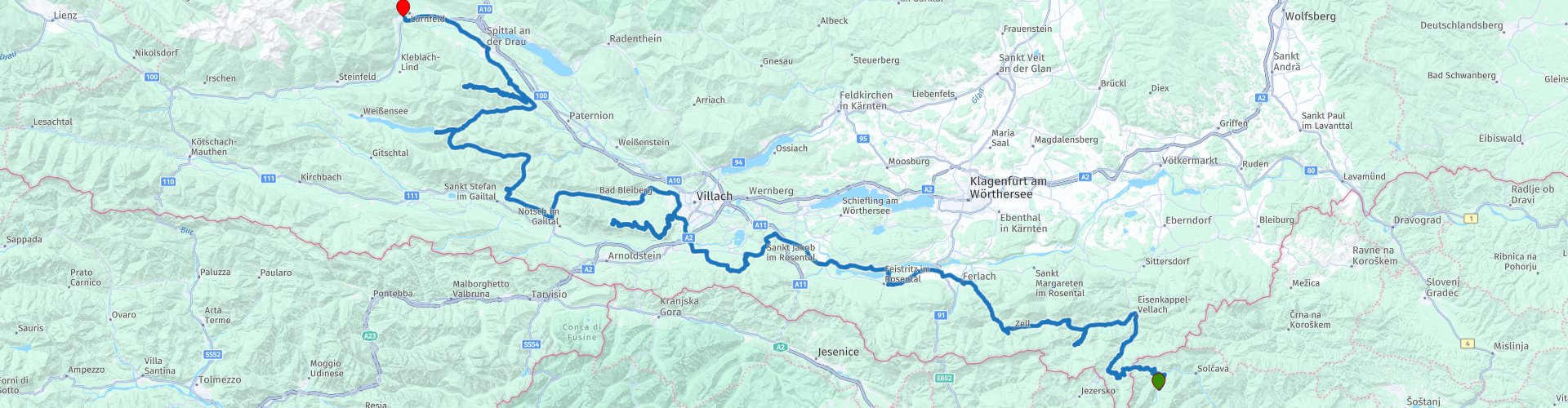
 The climb over the first mountain pass begins immediately upon leaving Logarska Dolina. This only stops at the very last moment, at the access route to the hotel in Sachsenburg. Along the way you will drive over mountain passes and panorama streets such as the Trögerner Klamm, Schaidasattel, Villacher Alpenstrasse and the Goldeck Panoramastrasse.
This 13th stage of a tour through Eastern Europe is a wonderful touring pleasure. One bend after another sends you further and further into Austria. You will see beautiful views along the way. Kaernten is undeniably a wonderful place to tour.
 Share this route


Animation

Verdict


Duration
6h 46m

Mode of travel
Car or motorcycle

Distance
275.02 km

Countries


 RouteXpert Review
 If I had to give today's route a title, I would call it the turn-around route. You will regularly have to turn around, because you have reached the end of a dead end ... And no, the waypoints are not wrong.
The route from Logarska Dolina to Sachsenburg passes through Kärnten. This is one of the 9 Bundesländer (provinces) in Austria and is considered one of the most beautiful provinces in the country due to the varied landscape. For motorcyclists this means that riding through rolling valleys and gorges is alternated with spectacular climbs over dead ends, among other things. A more appropriate title for such a dead end road is Panorama Street: from the valley you climb higher and higher. Along the way you regularly have the opportunity to enjoy the many views. The icing on the cake is a delicious break at a mountain restaurant with spectacular views (often 360 degrees).
Today we leave Slovenia behind. Weather permitting, you will have breakfast with a view this morning. On some days the clouds hang high in the Logar valley, giving you a good impression of the beautiful surroundings. One last time you drive through the valley towards the exit and you are waved goodbye by the golden brown colored Longhorns.
There is no time to wake up peacefully. Immediately after leaving the valley you will be put to work. The Paulitschsattel immediately demands all your attention. Tight turns are followed by even tighter hairpin turns and finally the border crossing on top of the mountain. Customs are present, so keep in mind that your passport will be checked. You can usually continue with a gentle swing and start the descent to Bad Eisenkappel. Here you can, if necessary, refuel (rp 4) and also take a photo of Hagenegg Castle (rp 3). Little is known about the origin and dating of this castle. There are suspicions that a Roman fort has already stood on this spot to protect an old Roman road. The oldest part of the current castle is said to stand on remains of a structure from 1316. Currently, the castle is owned by a noble family, so it is not open for visitors. From the parking lot you have a view of the part that was built in the 15th and 16th centuries.
You have arrived in Kärnten, Austria, after crossing the border. In Dutch we also call this area Carinthia. This name is not entirely correct, because it refers to a larger area that runs in Slovenia, in addition to Austria, between the Karawanken and the Alpenhauptkamm. When driving up the various panoramic streets you will regularly enjoy the view of both mountain areas.
But first we dive into a Klamm or Schlucht. These are gorges, often caused by erosion by water for centuries. The Trögerner Klamm (your first dead end road today) was created because the Trögernbach found its way through the soft limestone of the area. The result is a wonderful ride through the Trögerner gorge. If you take a good look around you, you will also see different layers of a sea in the rock around you. Because the area in and around the Klamm is a protected nature reserve, you will see a large sign at the entrance of the gorge (rp 5). The local mayor asks you to visit the gorge on foot. It is not a prohibition sign. Feel free to visit the canyon by motorcycle, but do it respectfully. In general, the gorge is quite calm. There are few tourists. Keep in mind that forestry is practiced in this area. It could just be that a large PKW fully loaded with tree trunks comes towards you in a blind corner. You can take a break at the end of the gorge. In the summer months you will find, next to the picnic spot, a cabin (rp 6) where you can buy tasty simple dishes and drinks. Ultimately, there is no other option but to turn around and drive back the same way. Fortunately this is not a punishment!
Via the simple and quiet Schaidasattel (rp 7) you continue the route further to the West. With a maximum height of 1069m, it is not an exciting climb. On the way you may come across signs to enter the Hochobir-Panoramastrasse. I left this panorama street (with toll) out of the route. The way up is quite narrow and unclear, the climax at the top is disappointing. Today you will come across more beautiful panoramic streets ...
But first you discover another characteristic of Kärnten. Many people call this province a wet province. Fortunately, this does not refer to rain showers, but to the large presence of lakes and rivers. You will encounter the first immediately after you have entered a more densely populated area. You cross the Drau river with the Feistritzer on the left and the Ferlacher reservoir on the right (rp 8). Both reservoirs provide a large part of the local population with electricity. If you have trouble navigating today: the Drau river (rp 10) is a good guide. As long as you continue to follow the route westward, you will automatically arrive at the end point in Sachsenburg. You can also follow the river eastwards. You then have a beautiful ride through Slovenia, Croatia and Hungary. Eventually you will arrive at the border with Serbia, where the Drau (or Drava) ends in the Danube. If you have an extra week off, this is a nice extra to hopefully already a successful holiday.
After rp 11 you deviate from the Drau to visit Burgruine Finkenstein (rp 13). This medieval fortress is located on top of a gorge, at the foot of the Karawank Mountains. You can stop here to take pictures and enjoy the view of Lake Faak. You can also take a longer break here at the local restaurant. The route does not include a longer stop here, as the climb on the Villacher Alpenstrasse is slowly becoming visible.
It takes about 20 minutes to arrive at the toll booth (rp 14) for Villacher Alpenstrasse. With the purchased vignette you have access to today's second dead end. The panorama street will lead you to an altitude of approximately 2000m in the Dobratsch nature park. The broad, tightly paved street meanders upwards. Along the way you have several viewpoints, where you have a good view of the Karawank mountains in Slovenia and the mountains in the North. All this hard work should eventually be rewarded: on top of the summit, you can take a break at the Rosstrattenstüberl. This large mountain restaurant naturally has a lovely terrace!
After the break, the big turnaround starts again. If you stopped here and there at the viewpoints on the way up, you can now sail down over the big curves.
The road continues to the Weißensee (rp 19). This is a well-known name for the Dutch. The Elfstedentocht is an important annual event in the Netherlands and is a skating competition of approximately 200 km over natural ice in Friesland. It causes the necessary "Eleven Cities" fever for many skating fans. Do the temperatures drop below freezing for long enough for the rivers to freeze over? 1997 was the last time the race was actually held in Friesland. As an alternative, the alternative Elfstedentocht is held annually on this Weißensee.
You can continue the route by turning around ???? and drive back the same way. In the end you really visit the last dead end of the route: the Goldeck-Panoramastraße. At the toll booth (rp 21) you buy another vignette to be able to drive on the road. A few hairpin bends later you drive via a sloping road to the top at an altitude of approximately 1890m. Here too you can take a break (Gasthof Wieser Hütte) to turn around again and descend the same road.
Once you have left the panorama street you can see the Millstätter See and Spittal an der Drau in the distance, where you can also refuel (rp 26). The river will accompany you towards your end point. At Gasthof Zum Goldenen Rössl, the owner Ferdinand greets you friendly. He shows you where you can safely park your motorcycle (via a narrow passage), and then settle down on the terrace with a delicious cold beer or glass of wine. Enjoy it!
The route gets 5 points from me. It is a wonderful ride through the beautiful nature reserve of Kärnten. The panorama streets are a joy to drive, with the climax always a magnificent view of the surrounding mountains, valleys and lakes. In good Austrian custom, you can take a pleasant break at the mountain restaurants on any mountain peak. With a length of 275 km, the route is easy to drive. If you are at risk of arriving late at your final destination due to the many pauses and enjoying the views, you can easily shorten the route by skipping one of the dead ends.


 Links
Links  Usage
Usage Want to download this route?
You can download the route for free without MyRoute-app account. To do so, open the route and click 'save as'. Want to edit this route?
No problem, start by opening the route. Follow the tutorial and create your personal MyRoute-app account. After registration, your trial starts automatically.  Disclaimer
Use of this GPS route is at your own expense and risk. The route has been carefully composed and checked by a MyRoute-app accredited RouteXpert for use on TomTom, Garmin and MyRoute-app Navigation.
Changes may nevertheless have occurred due to changed circumstances, road diversions or seasonal closures. We therefore recommend checking each route before use.
Preferably use the route track in your navigation system. More information about the use of MyRoute-app can be found on the website under 'Community' or 'Academy'.

Carinthia
About this region
Carinthia (German: Kärnten [ˈkɛʁntn̩] (listen); Slovene: Koroška [kɔˈɾóːʃka] (listen)) is the southernmost Austrian state or Land. Situated within the Eastern Alps, it is noted for its mountains and lakes. The main language is German. Its regional dialects belong to the Southern Bavarian group. Carinthian Slovene dialects, forms of a South Slavic language that predominated in the southeastern part of the region up to the first half of the 20th century, are now spoken by a small minority in the area.
Carinthia's main industries are tourism, electronics, engineering, forestry, and agriculture. The multinational corporations Philips, Infineon Technologies and Siemens have large operations there.
Read more on Wikipedia
Carinthia's main industries are tourism, electronics, engineering, forestry, and agriculture. The multinational corporations Philips, Infineon Technologies and Siemens have large operations there.
View region
 Statistics
  35
35Amount of RX reviews (Carinthia)
 35528
35528Amount of visitors (Carinthia)
 4811
4811Amount of downloads (Carinthia)
 Route Collections in this region
 The 24 Most Beautiful Alpine Routes
The Alps, The Alps are a mountain range in Europe, stretching from the French Mediterranean coast in the southwest to the Pannonian Plain in the east. The area of the mountain range is more than 200,000 km².
In other words Passes and Mountain Roads!
Driving through the mountains is great! Especially over the mountain passes with hairpin bends and narrow winding roads. Every bend a different view where you can enjoy. There are many beautiful mountain passes in the Alps.
A selection that has also been incorporated into these routes:
The Stlevio Pass:
The Stelvio Pass, also known as Passo dello Stelvio, is mainly known for the stage in the Giro d'Italia. Due to the length and the difference in height, this pass is seen as one of the toughest tests in cycling. The Stelvio Pass reaches a maximum height of 2758 meters and is therefore one of the highest in the Alps. The pass connects the towns of Bormio and Prato Allo Stelvio. In winter the pass is closed due to heavy snowfall.
The Reschenpass:
The Reschenpass, also known as Passo di Resia, connects the Austrian state of Tyrol with the Italian province of South Tyrol. The pass reaches a maximum height of 1,504 meters and has been one of the most important north-south connections in the Alps in recent centuries. The pass was used long before Roman times. Along the way you will pass several highlights and historical relics. One of the highlights is the Reschensee. This lake was created after the construction of the dam and has completely submerged the village of Graun. The only thing that reminds of that is the clock tower in the middle of the lake.
Col du Galibier:
The French mountain pass Col du Galibier connects the towns of Saint-Michel-de-Maurienne and Briançon via the Col du Lautaret in the south and the Col du Télégraphe in the north. The mountain pass is part of the Tour de France and very much feared, due to the fact that it can only be reached via the other two mountain passes. The pass reaches a maximum height of 2646 meters. From there you can take a walk to the viewpoint at 2704 meters. You can admire the peaks of the Grand Galibier, Mont Blanc and La Meije here.
The Grossglockner High Alpine Road:
With a height of 3798 meters the Grossglockner is the highest mountain in Austria. To fully enjoy this impressive mountain, you can drive over the Grossglockner High Alpine Road and the accompanying pass. The route starts from Bruck am Grossglockner and ends in Heiligenblut. Of course you can drive in two directions. The pass reaches a maximum height of 2504 meters and is closed in winter due to heavy snowfall. Along the way you pass several stops with fun activities, information points, mountain huts and viewpoints. A visit to the Kaiser-Franz-Josefs-Höhe and Pasterzen Glacier is highly recommended.
The Col d'Izoard:
Just like the Col du Galibier, the Col d'Izoard is also part of a stage of the Tour de France. The mountain pass connects Briançon with the valley of the river Guil. The pass is partly located in the Regional Natural Park du Queyras and reaches a maximum height of 2360 meters. What is special about the Col d'Izoard is the barren and rocky landscape. Sometimes it feels like driving a car over the moon! Along the way you can stop at several points to enjoy the beautiful view.
The Bernina Pass:
The Bernina Express is one of the most famous rail trains in Switzerland and the Alps. The route is beautiful and partly included on the UNESCO World Heritage List. Parallel to the railway lies the Bernina pass, which connects the Veltlin valley with the Egandin valley. This beautiful Alpine road has a total length of 56 kilometers and reaches a maximum height of 2328 meters. Along the way you can enjoy views of the Morteratsch Glacier.
The Sella Pass:
The Sella Pass, also known as Passo di Sella, takes you over one of the most impressive mountain ranges in the Dolomites: the Sella massif. The pass connects Valle di Fassa with Val Gardena and reaches a maximum height of 2236 meters. At this height is also the border of the Italian provinces of Trentino and Bolzano. Along the way you can enjoy the view of this spectacular mountain world. Admire, for example, the three peaks of the Sasso Lungo massif, the Sella massif or the peaks of the Marmolada. You can also drive the Sella pass in combination with the Gardena pass, Pordoi pass and Campolongo pass.
The Grimsel Pass:
The Grimsel Pass connects Goms in Wallis with the Halis Valley in the Bernese Oberland. The pass reaches a maximum elevation of 2165 meters and is closed in winter due to snowfall. Over the centuries, the mountain pass has played an important role in trade between Switzerland and Italy. Now it is mainly the reservoirs that have an important function. These are used to generate electricity. The landscape you drive through is rugged, rocky and impressive. On top of the pass is a hotel and a restaurant with a special marmot park. The Dodensee (Totensee) is also located here. This lake owes its name to the many soldiers who died in the time of Napoleon.
The Gotthard Pass:
The Gotthard Pass, also known as Passo del San Gottardo and Saint Gotthard, connects the Swiss towns of Airolo and Andermatt. The mountain pass and associated tunnel are especially known among holidaymakers driving from Switzerland to Italy. But where the majority opt for the tunnel, it is precisely the pass that really completes the holiday. The Gotthard Pass has a length of about 26 kilometers and reaches a maximum height of 2106 meters. The route is beautiful and takes you along old villages and beautiful views.
The Silvretta High Alpine Road and Silvretta Pass:
The Paznaun Valley in Tyrol and the Montafon in Vorarlberg are connected by the Silvretta High Alpine Road. The route has a length of 22.3 kilometers and leads from Galtür to Partenen in 34 hairpin bends, via the 2032 meter high Bielerhöhe. The Silvrettasee is also located at this point, where you can enjoy a lovely walk. The pass is closed in winter due to snowfall.
The Simplon Pass:
Just like the Gotthard Pass, many holidaymakers also travel over the Simplon Pass every year. This mountain pass connects the Rhone Valley in the canton of Valais with the Valle d'Ossola in Piemonte. The pass is open all year round and reaches a maximum height of 2005 meters. Along the way you pass a number of buildings, including the well-known Simplon Hospiz from 1825. The hospiz is managed by the monks of St. Bernard. From the highest point on the pass, all kinds of hiking routes are possible and you will also come across a hotel where you can spend the night.
The Gerlos Pass:
The Gerlos Pass connects the Salzach Valley in the Salzburgerland with the Zillertal Valley in Tyrol. The pass is part of the Gerlos Alpenstraße and runs right through the Hohe Tauern National Park. Along the way you can enjoy beautiful views of the surroundings. The pass has a length of 12 kilometers and reaches a maximum height of 1531 meters. A ride over the Gerlos Pass can be ideally combined with a visit to the Krimmler Wasserfälle.
The Great St. Bernard Pass:
The Great St. Bernard Pass, better known as Col du Grand Saint Bernard, connects the Italian province of Valle d'Aosta with the Swiss canton of Valais. The pass is one of the highest in Switzerland and reaches a maximum height of 2469 meters. Like a number of other mountain passes in this list, the Great St. Bernard Pass has also been used as a connecting road for centuries. The pass is named after the St. Bernard dogs that used to help stranded travelers along with the monks. The pass is closed in winter.
The Timmelsjoch High Alpine Road:
The Timmelsjoch High Alpine Road connects the towns of Sölden in the Ötztal and Meran in South Tyrol. Tolls must be paid on the Hochgurgl - Moos route. Via a mountain road with about 60 hairpin bends you drive through a beautiful mountain world. With the Timmelsjoch Experience you can learn more about the history, the road and the environment via various stations. You can also visit the Top Mountain Crosspoint museum.
Col de l'Iseran:
With a maximum pass height of 2770 meters, the Col l'Iséran is one of the highest mountain passes in the Alps. The pass connects Bourg-Saint-Maurice with Bonneval-sur-Arc. Via a road full of hairpin bends you pass, among other things, Val-d'Isère and a side valley of the Maurienne that lies entirely in the National Park de la Vanoise. You can spot animals such as marmots and chamois and there is also a restaurant with a chapel on top of the pass.
The Gavia Pass:
The Gavia Pass (Italian Passo di Gavia) is a mountain pass in the Italian Alps, in the Lombardy region.
It is one of the highest pass roads in Europe. The road leads through the unspoilt Stelvio National Park. The road was built in the First World War to supply Italian soldiers who fought in the Italian-Austrian border area. The pass height is one of the most beautiful in the Alps. Here is the large Lago Bianco with, to the north, the mountain San Matteo (3684 meters). Lago Nero is slightly lower on the south side of the pass. Here the mountain group of the Adamello determines the view. There are many well-marked walks in the area. During the winter the pass is closed due to the heavy snowfall. The pass is often closed until May and June due to the large amount of snow.
Promoter has made a selection of the 24 Most Beautiful Alpine routes that they have set out in recent years.
The routes go through:
France
Austria
Switzerland
Italy
The most beautiful roads, the most beautiful views, the most beautiful viewpoints. The highest mountains, the fastest descents, hairpin bend after hairpin bend, you name it you can't get enough of it.
If you go on holiday in this region, take advantage of it, ALL routes in this collection have been checked and made equal for TomTom, Garmin and MyRoute-app Navigation by a MyRoute-app RouteXpert.
Have fun with this collection and while driving one of these routes. Enjoy all the beauty that the Alps and the Dolomites have to offer. Click on “View route” to read the review of the chosen route.
I would like to hear your findings about the route(s).
View Route Collection
The 12 most beautiful car and motorcycle routes in Carinthia
“Motorradland Kärnten” where you feel so wonderfully welcome as a motorcyclist!
Own website for motorcyclists, own curated routes, hotels, campsites and guest houses with attention for motorcyclists, a wonderful area where motorcyclists are very popular.
Kärnten or Carinthia, at the crossroads of the Germanic, Slavic and Roman worlds. Three cultures within a few kilometres, southern flair, culinary delights, cross-border tours. Breakfast in Italy, lunch in Slovenia, dinner in Austria - all in one day. Experience the diversity in the borderless Alps-Adriatic region, the area for motorcyclists.
Extensive day trips on winding mountain paths, romantic panoramic routes and beautiful lakes, here the 12 TOP routes Kärnten / Carinthia. Enjoy!
View Route Collection