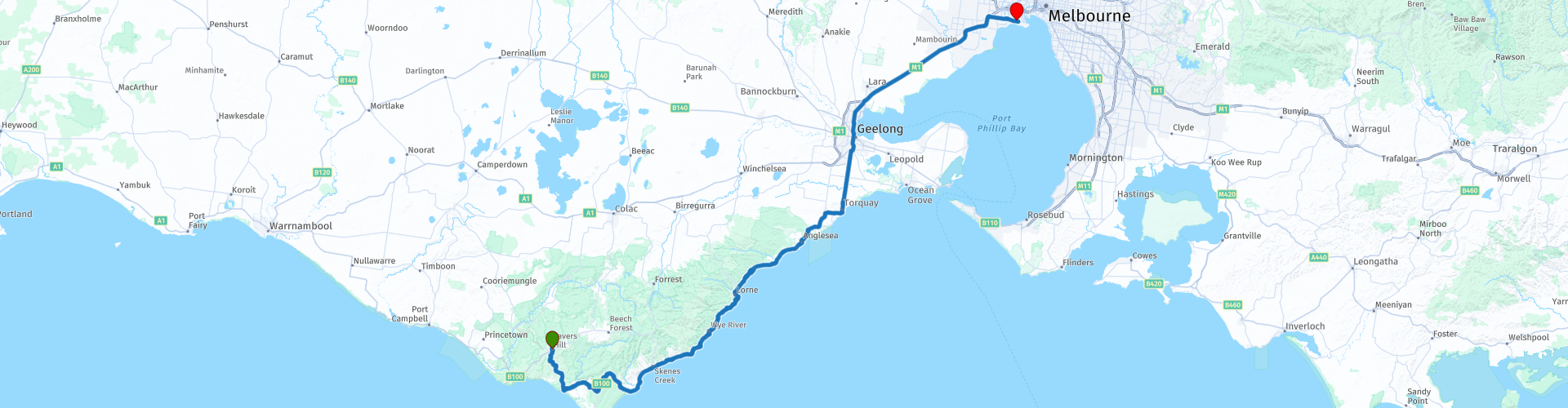
R53 VIC Lavers Hill to Williamstown

This route was brought to you by:
RouteXpert Hans van de Ven (Mr.MRA)
Last edit: 23-01-2021
 Route Summary
 Australia is very big; 8 million km2, that is more than 226 times larger than the Netherlands! Has a diversity of flora and fauna; the most diverse types of plants, trees and animals, especially birds and a lot of typical Australian marsupials, which you will not find anywhere else in the world!
Enjoy all the beauty enormously: From the evergreen tropical rainforests, to the vast Outback; from the desert to the countless and quiet idyllic palm beaches; from the winter sports areas in the south-east to the vibrant and impressive metropolis of Melbourne, Sydney and Perth.
You will see and experience it all in this great tour of Australia, a tour to remember!
Starting Point: Lavers Hill, Otway Junction Motor Inn
End Point: Williamstown, Quest Williamstown North
The route is made equal for TomTom, Garmin and MyRoute-app Navigation users.
NOTE: DRIVE LEFT!
 Share this route


Animation

Verdict


Duration
3h 41m

Mode of travel
Car or motorcycle

Distance
223.82 km

Countries

 RouteXpert Review
 After about 30 minutes, if you feel like it, you can take a walk through the rainforest at Maits Rest. You will walk among native flora and fauna, ancient plants and spectacular scenery while learning more about the creatures and their habitats. As you drive further, in the town of Apollo Bay, you can stop at a supermarket to stock up on food and drinks to take along the way, so you can grab some snacks at the many viewpoints along the way. After 1 hour drive you will come to the 1st viewpoint and soon you will come to the next, Cape Patton Lookout,
this vantage point offers more spectacular ocean views and an equally spectacular panorama of the long string of ocean beaches that flow into Apollo Bay, along with the impossibly green hills of the hinterland. Next is the wreck of the WB Godfrey, this is one of the few shipwrecks along the Great Ocean Road that can be seen from dry land. Furthermore, you come to Mount Defiance Lookout, this magnificent viewpoint is one of the most popular lookouts on the Great Ocean Road - for good reason!
Further up the route you can take a hike again at the Sheoak Falls Walk, the hidden waterfalls of Sheoak Falls are one of the most popular waterfalls near Lorne.
In Lorne, a stop is planned at The Pier Seafood Restaurant and you will also pass Lorne the lowest point of the Great Ocean Road. After Lorne you pass the places Aireys Inlet, Anglesea, Torquay, where the Great Ocean Road also ends this route, Geelong where you can refuel and eat a burger and then travel the last 50 KM to Williamstown, where another hotel awaits you and you can cool off in the swimming pool.
This 4-star rated route is Australia's most scenic road, again with some lovely views and curves that seem endless. Another day you will not soon forget.
General info:
Victoria is the smallest state on the Australian mainland. It is located in the southeastern corner of the continent and has a population of over 6.5 million on an area of 227,416 km². The border with New South Wales is the south bank of the River Murray. It borders South Australia to the west and the Indian Ocean to the south. Brass Strait lies between Victoria and Tasmania. Victoria, like Queensland, is named after Queen Victoria.
The capital Melbourne with about 70% of the state's population and located on the north side of Port Philipbaai has Australia's busiest container port. The city is the state's economic and cultural center. This town is also home to the State Library of Victoria.
There are wide variations in climate in Victoria, from the moderately humid eastern Gippsland to the snow-capped, almost 2000 meter high Australian Alps in the northeast, and from the hot semi-desert of the northwest to the lush irrigation areas along the Murray. Mount Bogong is the highest mountain in Victoria.
Gold was found near Raspberry Creek in Victoria in the 19th century. This gold was of very high quality. Hamlets were founded along the brook. The hamlet of A1 Mine Settlement takes its name from this period.
History
The area was already inhabited when the first Anglo-Australians settled there in 1803. In 1835, John Batman bought an area from the native population on which to build the city of Melbourne. In 1851 the area was detached from New South Wales and in 1855 it was given the status of a self-governing colony. A parliament consisting of two chambers was elected. The first Prime Minister was William Haines. In 1901, the six Australian colonies formed the Commonwealth of Australia, and Victoria has been a federal state of that country ever since.


 Links
Links  Usage
Usage Want to download this route?
You can download the route for free without MyRoute-app account. To do so, open the route and click 'save as'. Want to edit this route?
No problem, start by opening the route. Follow the tutorial and create your personal MyRoute-app account. After registration, your trial starts automatically.  Disclaimer
Use of this GPS route is at your own expense and risk. The route has been carefully composed and checked by a MyRoute-app accredited RouteXpert for use on TomTom, Garmin and MyRoute-app Navigation.
Changes may nevertheless have occurred due to changed circumstances, road diversions or seasonal closures. We therefore recommend checking each route before use.
Preferably use the route track in your navigation system. More information about the use of MyRoute-app can be found on the website under 'Community' or 'Academy'.