Day 10 TCH Regina to Brandon

This route was brought to you by:
RouteXpert René Plücken (MRA Master)
Last edit: 12-02-2021
 Route Summary
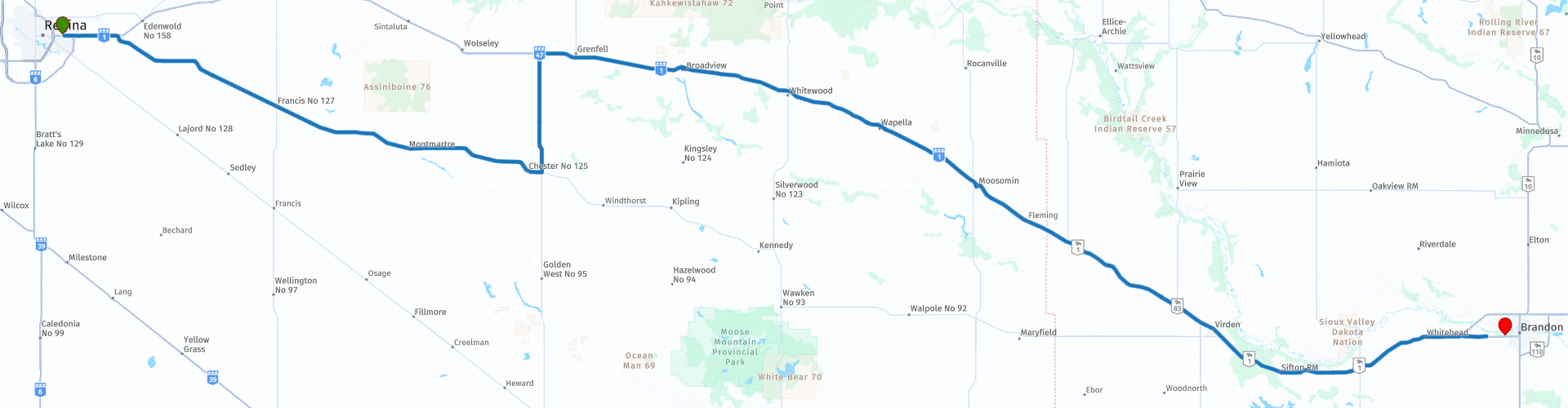
 This is part 10 that runs from Regina to Brandon.
The Trans Canada Highway passes through all the southern provinces of the country. The route can be driven in different ways. There are namely in various alternative routes that also belong to the TCH. The total distance is around 8,000 km. We not only drive the TCH, but will take the rural roads as much as possible, because only highway driving is too boring and Canada has many beautiful roads through its beautiful landscape.
You drive through all provinces and through very varied and scenic landscapes, from the Rockies in the West, the Central Prairies to the Eastern Maritimes and the Northern Forest.
The riding season is generally April through October with longer seasons on the west coast and southern Ontario.
Provide good all season clothing or bring rain gear, depending on the province and the season the weather can change and you may be surprised by a rain or even a snow or hail shower, so be prepared.
In Canada the metric system is used, so speeds are indicated in Km / h. A helmet requirement (DOT approved) applies throughout Canada.
You will see many wildlife throughout Canada. your similar animals from province to province, such as deer, buffalos, moose, caribou, wolves, pumas, bears, mountain goats, sheep, lynx, coyotes, foxes, raccoons, badgers, various rodents and all kinds of birds.
Even if it is very tempting to stop for a photo, don't do it, it can be very dangerous.
 Share this route


Animation

Verdict


Duration
4h 13m

Mode of travel
Car or motorcycle

Distance
387.44 km

Countries

 RouteXpert Review
 The first part we do not drive on the Trans Canada Highway but we take the no.48 to Montmartre, a small place where you can stop to take a photo at a replica of the Eiffel Tower (RP3).
After about 30 kilometers we turn left and take the gravel road No. 47 (RP5-6) back to the Trans Canada Highway.
Along the TCH is the town of Broadview where you can visit the Broadview Historical Museum (RP7). This is one of the "largest" small town museums on the prairies. It is a window to the efforts, joys and sorrows of a diverse and determined people. From drought to flood, from bumper crops to failure and through two world wars, the Broadview experience is a triumph of setbacks!
Within the walls of the museum you can see Broadview's Mascot (Sergeant Bill) of the Canadian Forces in the Great War; the clothes of the period, you can visit the store and see some of the prices of the goods and see thousands of other artifacts housed in the museum.
As you walk around the grounds you can visit the old Highland School, the post office, stroll through a Canadian Pacific Railway Caboose or an Indian log cabin.
In the Highland School you can browse old yearbooks, view the used textbooks or sit behind the desk and revive history.
We stop to refuel and have lunch in Moosomin (RP8 and 9), on Main street there are a number of restaurants to choose from.
At RP11 we stop at the Manitoba Visitor Information Center, a visitor information center of Travel Manitoba in The Forks, which features interactive technology that immerses you in the tourist experiences of Manitoba. You can also purchase a Manitoba Provincial Park Pass, should you wish to visit the park.
After this it is still 110 kilometers over the TCH to Brandon. I appreciate this route with 3 *** Stars because of the sights on the way and the beautiful landscape (although flat). The ride itself is fairly straightforward and there are a number of options for driving via a different route (unpaved roads), but these are also straight.


 Links
Links  Usage
Usage Want to download this route?
You can download the route for free without MyRoute-app account. To do so, open the route and click 'save as'. Want to edit this route?
No problem, start by opening the route. Follow the tutorial and create your personal MyRoute-app account. After registration, your trial starts automatically.  Disclaimer
Use of this GPS route is at your own expense and risk. The route has been carefully composed and checked by a MyRoute-app accredited RouteXpert for use on TomTom, Garmin and MyRoute-app Navigation.
Changes may nevertheless have occurred due to changed circumstances, road diversions or seasonal closures. We therefore recommend checking each route before use.
Preferably use the route track in your navigation system. More information about the use of MyRoute-app can be found on the website under 'Community' or 'Academy'.

Saskatchewan
About this region
Saskatchewan ( (listen) sə-SKATCH-ə-wən; Canadian French: [saskatʃəwan]) is a prairie and boreal province in Western Canada, the middle of the three prairie provinces. It is bordered on the west by Alberta, on the north by the Northwest Territories, on the east by Manitoba, to the northeast by Nunavut, and on the south by the U.S. states of Montana and North Dakota. Saskatchewan, along with Alberta make up the only landlocked provinces of Canada. As of Q1 2020, Saskatchewan's population was estimated at 1,181,987. Nearly 10% of Saskatchewan’s total area of 651,900 square kilometres (251,700 sq mi) is fresh water, which is composed mostly of rivers, reservoirs, and the province's 100,000 lakes. Moderating bodies of water render severe winters throughout the province, as a result of Saskatchewan's continental climate. Southern areas have very warm or hot summers. In winter, temperatures below −45 °C (−49 °F) are possible even in the south during extreme cold snaps.
Residents primarily live in the southern prairie half of the province, while the northern boreal half is mostly forested and sparsely populated. Of the total population, roughly half live in the province's largest city Saskatoon or the provincial capital Regina. Other notable cities include Prince Albert, Moose Jaw, Yorkton, Swift Current, North Battleford, Melfort, and the border city Lloydminster (partially within Alberta). English is the primary language of the province, with 82.4% of Saskatchewanians speaking English as their first language.Saskatchewan has been inhabited for thousands of years by various indigenous groups. Europeans first explored the area in 1690 and first settled in the area in 1774. It became a province in 1905, carved out from the vast North-West Territories, which had until then included most of the Canadian Prairies. In the early 20th century the province became known as a stronghold for Canadian social democracy; North America's first social-democratic government was elected in 1944. The province's economy is based on agriculture, mining, and energy.
The current Lieutenant Governor is Russell Mirasty. The current premier is Scott Moe.
In 1992, the federal and provincial governments signed a historic land claim agreement with First Nations in Saskatchewan. The First Nations received compensation and were permitted to buy land on the open market for the bands; they have acquired about 3,079 square kilometres (761,000 acres; 1,189 sq mi), now reserve lands. Some First Nations have used their settlement to invest in urban areas, including Regina and Saskatoon.
Read more on Wikipedia
Residents primarily live in the southern prairie half of the province, while the northern boreal half is mostly forested and sparsely populated. Of the total population, roughly half live in the province's largest city Saskatoon or the provincial capital Regina. Other notable cities include Prince Albert, Moose Jaw, Yorkton, Swift Current, North Battleford, Melfort, and the border city Lloydminster (partially within Alberta). English is the primary language of the province, with 82.4% of Saskatchewanians speaking English as their first language.Saskatchewan has been inhabited for thousands of years by various indigenous groups. Europeans first explored the area in 1690 and first settled in the area in 1774. It became a province in 1905, carved out from the vast North-West Territories, which had until then included most of the Canadian Prairies. In the early 20th century the province became known as a stronghold for Canadian social democracy; North America's first social-democratic government was elected in 1944. The province's economy is based on agriculture, mining, and energy.
The current Lieutenant Governor is Russell Mirasty. The current premier is Scott Moe.
In 1992, the federal and provincial governments signed a historic land claim agreement with First Nations in Saskatchewan. The First Nations received compensation and were permitted to buy land on the open market for the bands; they have acquired about 3,079 square kilometres (761,000 acres; 1,189 sq mi), now reserve lands. Some First Nations have used their settlement to invest in urban areas, including Regina and Saskatoon.
View region
 Statistics
  3
3Amount of RX reviews (Saskatchewan)
 5389
5389Amount of visitors (Saskatchewan)
 125
125Amount of downloads (Saskatchewan)
 Route Collections in this region
 Trans Canada Highway
The Trans-Canada Highway (TCH) or Trans-Canadian Highway is a system of highways that cover all 10 provinces of Canada.
The Federal and Provincial Highways System that now forms the TCH were authorized by the Trans-Canada Highway Act of 1948 and opened in 1962. It was completed in 1971. The total length of the TCH is 7821 km.
Contrary to the American Interstate Highway System, the TCH does not consist of an unambiguous network of motorways, but forms a network of restricted access highways and other main routes that are more akin to the Dutch provincial roads. The route is indicated by a green shield with a white maple leaf.
The numbering of the roads that are part of the TCH is the domain of the provinces. Only the western provinces have aligned their numbering and the TCH has the designation Highway 1 there.
The main route of the TCH starts in Victoria in British Columbia and runs via Calgary and Regina to Winnipeg. From Winnipeg the route leads to Kenora in Ontario, after which several branches pass through Ontario to Ottawa.
Further east, the route passes through the province of Quebec via Montreal and Quebec, among others, to Moncton, New Brunswick. Then the TCH continues east through Nova Scotia, where a branch (via the Confederation Bridge) leads to Prince Edward Island. Another section runs down to the sea in the port city of Sydney, where a ferry service leaves for Channel-Port aux Basques on the island of Newfoundland. From there the route continues for more than 900 km to the provincial capital of St. John's, in the extreme southeast of the island.
We not only drive the TCH, but will take the rural roads as much as possible, because only Highway driving is too boring and Canada has many beautiful roads through its beautiful landscape. You drive through all provinces and through very varied and scenic landscapes, from the Rockies in the West, the Central Prairies to the Eastern Maritimes and the Northern Forest.
The riding season is generally April through October with longer seasons on the west coast and southern Ontario. Provide good all season clothing or bring rain gear, depending on the province and the season the weather can change and you may be surprised by a rain or even a snow or hail shower, so be prepared.
In Canada the metric system is used, so speeds are indicated in Km / h. A helmet requirement (DOT approved) applies throughout Canada.
You will see many wildlife throughout Canada. This varies from province to province, such as deer, buffalos, moose, caribou, wolves, pumas, bears, mountain goats, sheep, lynx, coyotes, foxes, raccoons, badgers, various rodents and all kinds of birds. Even if it is very tempting to stop for a photo, don't do it, it can be very dangerous.
The routes described in this review sometimes deviate from the Trans Canada Highway, bringing the total length to 9,300 kilometers. The routes are made so that you drive through the beautiful parts of Canada with truly beautiful panoramas and beautiful sights to visit, this differs from museums, parks to historical points. The routes are not too long so there is time to stop for photos and sights along the way. You can also choose to arrange and combine the stages differently or to add other routes to shorten or extend your journey. The routes are marked with a rating in stars, some routes are less challenging or interesting but are necessary to drive to the next point, which is why they often have a lower rating.
In the route description you will find more details about the routes and the points of interest along the way. These points and also hotels, restaurants, petrol stations etc. are indicated with a POI and sometimes also with a Route point. In the description you will also find links to interesting sites and to the routes that connect to that day.
The described routes are;
Day 01 TCH Victory to Nanaimo
Day 02 TCH Nanaimo to Hope
Day 03 TCH Hope to Kamloops
Day 04 TCH Kamloops to Revelstoke
Day 05 TCH Revelstoke to Lake Louise
Day 06 TCH Lake Louise to Calgary
Day 07 TCH Calgary to Medicine Hat
Day 08 TCH Medicine Hat to Moose Jaw
Day 09 TCH Moose Jaw to Regina
Day 10 TCH Regina to Brandon
Day 11 TCH Brandon to Winnipeg
Day 12 TCH Winnipeg to Kenora
Day 13 TCH Kenora to Ignace
Day 14 TCH Ignace to Thunder Bay
Day 15 TCH Thunder Bay to Marathon
Day 16 Thunder Bay to Wawa
Day 17 TCH Wawa to Sault Ste Marie
Day 18 TCH Sault Ste Marie to Espanola
Day 19 TCH Espanola to Mattawa
Day 20 TCH Mattawa to Ottawa
Day 21 TCH Ottawa to Montreal
Day 22 TCH Montreal to Quebec
Day 23 TCH Quebec to Riviere du Loup
Day 24 TCH Riviere du Loup to Grand Falls
Day 25 TCH Grand Falls to Fredericton
Day 26 TCH Fredericton to Moncton
Day 27 TCH Moncton to Charlottetown
Day 28 TCH Charlottetown to Truro
Day 29 TCH Truro to North Sydney
Day 30 TCH North Sydney to Corner Brook
Day 31 TCH Corner Brook to Grand Falls
Day 32 TCH Grand Falls to Clarenville
Day 33 TCH Clarenville to St John.
Have fun reading the reviews and planning your next road trip.
If you have driven this trip, I am very curious about your feedback!
View Route Collection