2 From Schwarzwald Lauterbad to Hochgurgl in Austria

This route was brought to you by:
RouteXpert Guy Heyns - Sr RouteXpert
Last edit: 10-12-2024
 Route Summary
 De route passeert hierbij over 3 passen: De Oberjoch, de Gaicht en de Hahntennjoch.
Naarmate u vordert merkt de aandachtige rijder de omgevingsverschillen, ook in hoogte, zeker wel op.
Behalve de mooie passen, brengt de route u door enkele zeer mooie en typische Oostenrijkse valleien
zoals de Lech- en Tannheimvallei.
En terwijl u langzaamaan opklimt in en naar de échte Alpen, vindt u in hotel Laurin eerst nog een bijzonder fijne rustplaats.
Deze route, ook al is het nog steeds een transferroute, gaat u al veel plezier en voorbereiding geven op het échte werk dat er aankomt in de speeltuin waarin u net bent garriveerd....
.
 Share this route


Animation

Verdict


Duration
7h 32m

Mode of travel
Car or motorcycle

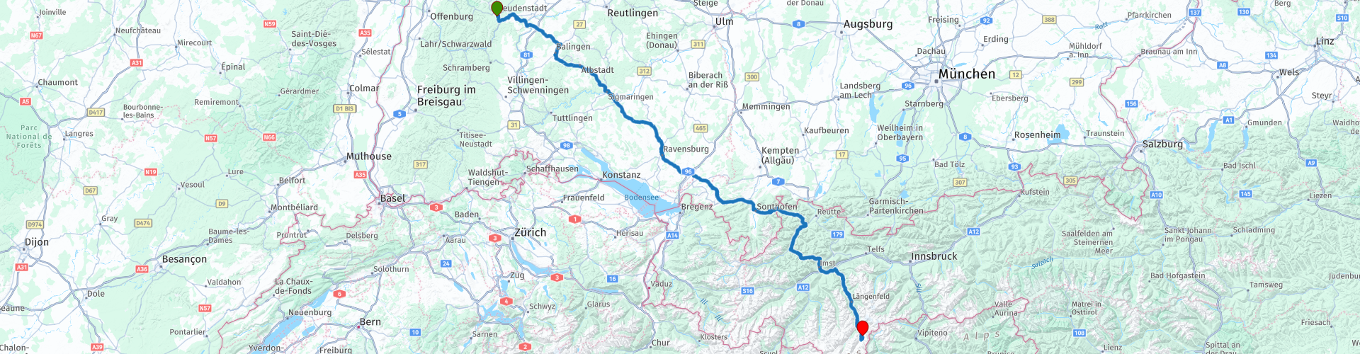
Distance
375.06 km

Countries


 RouteXpert Review
 Let's just say that, by ending this route, you have completed the approach to the Alps-Dolomites and that you will first enjoy a well-deserved, luxurious rest in the beautiful Alpen Laurin hotel, before you tomorrow, fully equipped, enter the real motor playground.
We leave the Gut Lauterbad hotel in Lauterbad and drive - exclusively on regional roads - to Hochgurgl. Where in the beginning the route still uses the larger tracks to gain some speed, the tourist aspect is gradually taking a more prominent place as you progress on this route.
It starts around route point 4 where you stroll along the Danube for a while. The Danube is, after the Volga, the second largest river in Europe. The 2850 km long river, originated in the Black Forest and fed mainly by rain and groundwater, flows through a total of 10 countries and that is a world record. The next in row is the Nile, which has to make do with one less country. You cross the Danube in Sigmaringendorf and that is immediately the start of the more 'green' environment through which you will drive.
At route point 6 you will return to the urban area near Ravensburg. Perhaps a name that sounds familiar, at least if you are a board game or jigsaw puzzle enthusiast. Ravensburg is after all the city after which the large board game and puzzle manufacturer has named itself. The manufacturer's headquarters has been located here since 1883.
After passing Ravensburg, the Alps will gradually work themselves more and more into your field of vision. And that is also one of the reasons why we love this route so much… it seems as if the Alps want to introduce themselves to you carefully and certainly not intrude…. Because once you've ridden them, they know all too well how addictive they can be.
The Alps are more and more visible and after about 175 km, near Wangen im Allgau, you start to feel it too. The terrain next to you is starting to 'hilly' more and more and the road is also starting to show a nice twist here and there. And where it slopes, here and there you also get a nice puddle of water; You will come across the 'Grosser Alpsee' at route point 8 and at route point 12 the Haldensee will treat you to another refreshing view.
But the Haldensee is already in Austria and we return to the story briefly to cross the border between Germany and Austria via that wonderful inswinger, the Oberjochpass.
The Oberjochpass is not only a wonderful border crossing, it is also the gateway to the particularly beautiful Tannheimer Tall. Here you really get the feeling of being in Austria.
The Oberjoch pass starts after Bad Hindelang with a few super nice climbing bends. Michelin quite rightly colors this road completely green. Enjoy it to the full, not only on the road, but also off it. We therefore also mark some places on the route where you can look into the valleys and there is space to park (rp 10) and to take a break.
You will therefore effectively enter Austria at rp 11. From now on you can officially say that you are a guest in the Austrian Alps and you will notice it on and next to the road where the peaks welcome you warmly.
21 kilometers after the Oberjoch, the Gaicht pass presents itself. Small but also tasty and the entrance to the well-known Lech tal, the birthplace of the Austrian picture postcards. If you don't get the Austrian feel here, have your sensors readjusted.
The elongated Hahntennjoch starts 27 kilometers further and takes you to the Inn Valley. A long pass, technically not difficult at all, but you climb nicely. The chance that you literally drive into the clouds does exist. In the Austrian mountains, low-hanging clouds caught between the mountains are a daily fact.
The descent takes you to the well-known Imst and then in Köningskapelle make the bend towards Italy. 75 kilometers later you reach the final destination, hotel Laurin in Hochgurgl, via a wonderfully sloping road.
This hotel offers you wonderful tranquility in absolutely luxurious conditions. You are literally 'in' the mountains at an altitude of 2150 meters and you really see the mountains everywhere. Whether you sit on the sun terrace, your room, the restaurant or in the relaxation area while studying the motorcycle tours that the hotel offers you. Sauna, hot tub, hammam, you name it… it's all there. And not only you, your motorcycle is also pampered in the free and covered parking lot. In other words, this is by far the ideal place to give the muscles the necessary rest. After all, you are here at the gate of the playground.
So wish you sweet dreams in hotel Laurin. Hopefully a little more about this route that, despite the fact that it is still a transition route, we give a 5 star rating: it goes over beautiful roads, mainly in green & 3 wonderfully soft passes can be ticked off the bucket list. You will get a very nice Austrian picture postcard printed on your retina in 'shaving flight' and the pampering at Hotel Laurin you will get in the bargain.
So dream away… tomorrow the party really starts with route number 3 from the collection….


 Links
Links  Usage
Usage Want to download this route?
You can download the route for free without MyRoute-app account. To do so, open the route and click 'save as'. Want to edit this route?
No problem, start by opening the route. Follow the tutorial and create your personal MyRoute-app account. After registration, your trial starts automatically.  Disclaimer
Use of this GPS route is at your own expense and risk. The route has been carefully composed and checked by a MyRoute-app accredited RouteXpert for use on TomTom, Garmin and MyRoute-app Navigation.
Changes may nevertheless have occurred due to changed circumstances, road diversions or seasonal closures. We therefore recommend checking each route before use.
Preferably use the route track in your navigation system. More information about the use of MyRoute-app can be found on the website under 'Community' or 'Academy'.