Heenrit van Echt naar Enkirch aan de Moezel

This route was brought to you by:
RouteXpert Leonor Orban - Sr. RouteXpert
Last edit: 10-03-2025
 Route Summary
 I rode the route in June 2019 with a small group of motorcyclists. It is a nice day-filling program with a number of nice breaks on the way. The route is fairly simple, so that people with little driving experience outside the Netherlands can get a nice first impression of the Eifel and the Moselle.
This outward journey is part of a three-day weekend trip to the Moselle. The other routes can be found in the links at the bottom of the detailed route review.
The route has been made the same for Garmin, TomTom and MyRoute-app Navigation.
 Share this route


Animation

Verdict


Duration
6h 54m

Mode of travel
Car or motorcycle

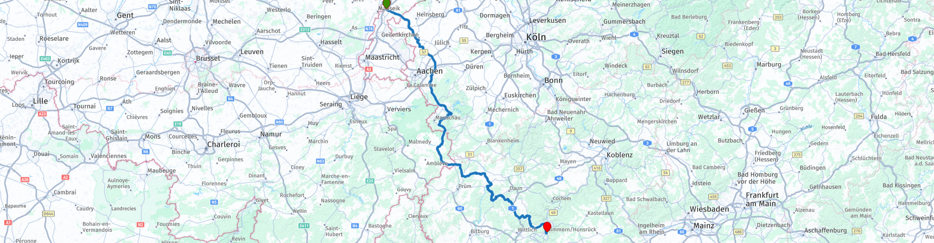
Distance
250.17 km

Countries


 RouteXpert Review
 The start of this weekend is fairly relaxed. This outward journey is not too challenging, which means that you will drive a comfortable ride to the Moselle. Nevertheless, the route is definitely worth it: you stay away from the highway all day. In order to be able to bridge the distance, you drive the first part of the route over through roads. After Aachen you drive into the Eifel and you are guided through Belgium and Germany via a nice mix of winding roads with occasionally beautiful views.
There are several roads around the Urftalsperre area that are prohibited for motorcyclists on weekends. This route avoids these roads, so you don't have to worry about it,
As soon as you leave the area around the Urftalsperre, you enter a quiet part of the Eifel. The road between Dedenborn and Rohren is a less frequently driven route (little tourist and local traffic), making it an almost private ride through the peaceful valley. And as icing on the cake, you can enjoy a well-deserved break in Rohren, at Restaurant "de Lange Man". This restaurant also has a hotel and is a good option to spend the night if you cannot reach the Moselle before the end of the day.
After this we look for even smaller roads in Belgium. Don't worry: the entire route is asphalted (all routes this weekend, by the way), even if it gives a different impression.
Later in the afternoon you will pass by Forsthaus Kasselburg. Here you can visit the ruins of an old castle, enjoy a refreshing drink and watch other motorcyclists work their way through a delightful hairpin bend.
After this break you can do a number of things. Of course you can resume your route and continue straight to the Moselle. You can also make a number of short stops along the way.
First of all, after you have left Gerolstein, you arrive on a wonderfully winding road through a large forest area. This road has no right! It offers good opportunities to take pictures of the other motorcyclists in your group. There are several places along the road where you can park for a short time to take action photos.
You also pass the village of Brockscheid. If you like it you can visit the "Eifeler Glockengiesserei" here. You will learn everything about the art of clock making under the guidance of a guide. Don't forget to visit their website in advance for opening times and reservations.
And of course, at the end of your day, you will pass a bend and the mountain will open for you with the Moselle below you. A place has been marked in the route to be able to park and take pictures of the view.
The route ends at Hotel Dampfmuhle in Enkirch. Unfortunately, there are no gas stations near this village. In the route the last gas station in Bengel (along the route) is marked in front of the hotel. Here you can fill up the tank before the end of your route, so that you can start the route the next day with confidence.
There are enough hotels along the Moselle to spend the night. We spent the weekend at Hotel Dampfmuhle, because it is a motor-friendly hotel. Next to the hotel is a large barn with ample space for motorbikes. This is closed in the evening. The hotel also has a large back garden with a grape-covered veranda and an outdoor swimming pool where you can cool off after a hot day on the motorcycle.
This route gets 3.5 stars from me, because it is a wonderful "fast" route to the Moselle. The roads along the way are varied and regularly offer beautiful views of the surrounding area. The route also offers sufficient challenge for people who are introduced to motorcycling "abroad" for the first time. The roads are winding enough to practice your technique well, but not too difficult to arrive at the hotel tired at the end of the day.
Additional comments about the route:
- There are a number of tight hairpin bends in the village of Dedenborn. This point is marked with route point 8. It is not too difficult, but as a starting hairpin biker a moment where you have to keep your attention and practice your technique well!
- The route is the same for TomTom, Garmin and the MyRoute-App Navigation.


 Links
Links  Usage
Usage Want to download this route?
You can download the route for free without MyRoute-app account. To do so, open the route and click 'save as'. Want to edit this route?
No problem, start by opening the route. Follow the tutorial and create your personal MyRoute-app account. After registration, your trial starts automatically.  Disclaimer
Use of this GPS route is at your own expense and risk. The route has been carefully composed and checked by a MyRoute-app accredited RouteXpert for use on TomTom, Garmin and MyRoute-app Navigation.
Changes may nevertheless have occurred due to changed circumstances, road diversions or seasonal closures. We therefore recommend checking each route before use.
Preferably use the route track in your navigation system. More information about the use of MyRoute-app can be found on the website under 'Community' or 'Academy'.

North Rhine-Westphalia
About this region
North Rhine-Westphalia (German: Nordrhein-Westfalen, pronounced [ˌnɔʁtʁaɪn vɛstˈfaːlən] (listen); Low Franconian: Noordrien-Wesfale; Low German: Noordrhien-Westfalen; Colognian: Noodrhing-Wäßßfaale), commonly shortened to NRW (German: [ɛnʔɛʁˈveː] (listen)), is a German state (Land) in Western Germany. With more than 17.9 million inhabitants, it is the most populous state of Germany. Covering an area of 34,084 square kilometres (13,160 sq mi), it is the fourth-largest German state by size. Apart from the city-states, it is also the most densely populated state in Germany.
North Rhine-Westphalia features 30 of the 81 German municipalities with over 100,000 inhabitants, including Cologne (over 1 million), the state capital Düsseldorf, Dortmund and Essen (all about 600,000 inhabitants) and other cities predominantly located in the Rhine-Ruhr metropolitan area, the largest urban area in Germany and the third-largest on the European continent. The location of the Rhine-Ruhr at the heart of the European Blue Banana makes it well connected to other major European cities and metropolitan areas like the Randstad, the Flemish Diamond and the Frankfurt Rhine-Main Region.
North Rhine-Westphalia was established in 1946 after World War II from the Prussian provinces of Westphalia and the northern part of Rhine Province (North Rhine), and the Free State of Lippe by the British military administration in Allied-occupied Germany and became a state of the Federal Republic of Germany in 1949. The city of Bonn served as the federal capital until the reunification of Germany in 1990 and as the seat of government until 1999.
Culturally, North Rhine-Westphalia is not a uniform area; there are significant differences, especially in traditional customs, between the Rhineland region on the one hand and the regions of Westphalia and Lippe on the other. The state has always been Germany's powerhouse with the largest economy among the German states by GDP figures.
Read more on Wikipedia
North Rhine-Westphalia features 30 of the 81 German municipalities with over 100,000 inhabitants, including Cologne (over 1 million), the state capital Düsseldorf, Dortmund and Essen (all about 600,000 inhabitants) and other cities predominantly located in the Rhine-Ruhr metropolitan area, the largest urban area in Germany and the third-largest on the European continent. The location of the Rhine-Ruhr at the heart of the European Blue Banana makes it well connected to other major European cities and metropolitan areas like the Randstad, the Flemish Diamond and the Frankfurt Rhine-Main Region.
North Rhine-Westphalia was established in 1946 after World War II from the Prussian provinces of Westphalia and the northern part of Rhine Province (North Rhine), and the Free State of Lippe by the British military administration in Allied-occupied Germany and became a state of the Federal Republic of Germany in 1949. The city of Bonn served as the federal capital until the reunification of Germany in 1990 and as the seat of government until 1999.
Culturally, North Rhine-Westphalia is not a uniform area; there are significant differences, especially in traditional customs, between the Rhineland region on the one hand and the regions of Westphalia and Lippe on the other. The state has always been Germany's powerhouse with the largest economy among the German states by GDP figures.
View region
 Statistics
  136
136Amount of RX reviews (North Rhine-Westphalia)
 63055
63055Amount of visitors (North Rhine-Westphalia)
 28452
28452Amount of downloads (North Rhine-Westphalia)
 Route Collections in this region
 The 10 most beautiful car and motorcycle routes in Limburg
Limburg, who thinks of Limburg, thinks of flan, coal mines, marl and the hill country. The coal mines have been closed for almost 40 years, the last load of coal was brought up from the Oranje-Nassau coal mine in Heerlen on 31 December and, as they say, South Limburg was transformed from Black to Green and unfortunately there is still little left. view of this period.
But not only pie, marl and coal in Limburg, but also a very beautiful province to tour by car or motorcycle and enjoy all the beauty that the province of Limburg has to offer. For this, the MyRoute app RouteXpert has put together a Top 10 of Car and Motorcycle routes for you.
All routes in this collection have been checked and made equal for TomTom, Garmin and MyRoute-app Navigation by a MyRoute-app RouteXpert.
If you think, I have a very nice route that should certainly not be missing from this collection, send it to:
email: routeexpert@myrouteapp.com
Subject: New Route for the Top 10 collection Province of Limburg composed by Hans van de Ven.
The route will then be reviewed and then added to the Top 10.
To make the Top 10 also the Top 10, 1 route will have to disappear from the Top 10, you can indicate this when submitting the new route.
Have fun with this collection and while driving one of these routes. Enjoy all the beauty that the Netherlands and in particular the province of Limburg has to offer. Click on “View route” to read the review of the chosen route.
I would like to hear your findings about the route(s).
View Route Collection
Top 5 Car and Motorcycle Routes in the Eifel
The Eifel is the eastern part of the medium plateau Eifel-Ardennes. It is located north of the Moselle and west of the Rhine. The largest part is in Germany, a small part is in Belgium, in the East Cantons. The German part of Eifel is located in the federal states of North Rhine-Westphalia and Rhineland-Palatinate. The highest point is the Hohe Acht with 747 meters.
Several chains can be distinguished in the Eifel:
The northernmost part is called the Nordeifel, which in Belgium connects to the High Fens;
To the east of this is the Ahrgebirge, this part is located north of the Ahr in the Ahrweiler district;
South of the Ahr is the Hohe Eifel (or Hocheifel), of which the Hohe Acht (747 m) is the highest point, and also the highest point in the entire Eifel region;
To the west, near the Belgian border, the hills are known as Schneifel, part of the wider Snow Eifel area with peaks reaching up to 698 metres;
South and east of the Hohe Eifel is the Volcano-Eifel, a volcanic area with many crater lakes (Maare).
The southern part of the Eifel is less high. The area is bisected by streams and rivers running southwards. These streams flow into the Moselle. The largest of these rivers is the Kyll; the hills around this river are known as the Kyllwald;
In the south, the Eifel ends in the Voreifel.
In the north of the Eifel there are some large reservoirs. The largest of these is the reservoir in the Roer that was created by the construction of the Roerdal dam.
The Nürburgring is also located in the Eifel, a well-known car circuit for Formula 1 races, among other things. Since 2004, part of the north of the Eifel has become the Eifel National Park. This National Park falls entirely within the German-Belgian nature park High Fens-Eifel. Another part of the Eifel falls within the South Eifel Nature Park.
Well-known throughout the Netherlands and Belgium by car and motorcyclists, so reason enough for the MyRoute app RouteXpert to compile a Top 5 of Car and Motorbike routes for you.
All routes in this collection have been checked and made equal for TomTom, Garmin and MyRoute-app Navigation by a MyRoute-app RouteXpert.
If you think, I have a very nice route that should certainly not be missing from this collection, send it to:
email: routeexpert@myrouteapp.com
Subject: New Route for the Top 5 collection Eifel composed by Hans van de Ven.
The route will then be reviewed and then added to the Top 5. To make the Top 5 also the Top 5, 1 route will have to disappear from the Top 5, you can indicate this when submitting the new route.
Have fun with this collection and while driving one of these routes. Enjoy all the beauty that the Eifel has to offer. Click on “View route” to read the review of the chosen route.
I would like to hear your findings about the route(s).
View Route Collection