From the High Eifel

This route was brought to you by:
RouteXpert Jan Koelstra (jan cabrio)
Last edit: 04-08-2024
 Route Summary
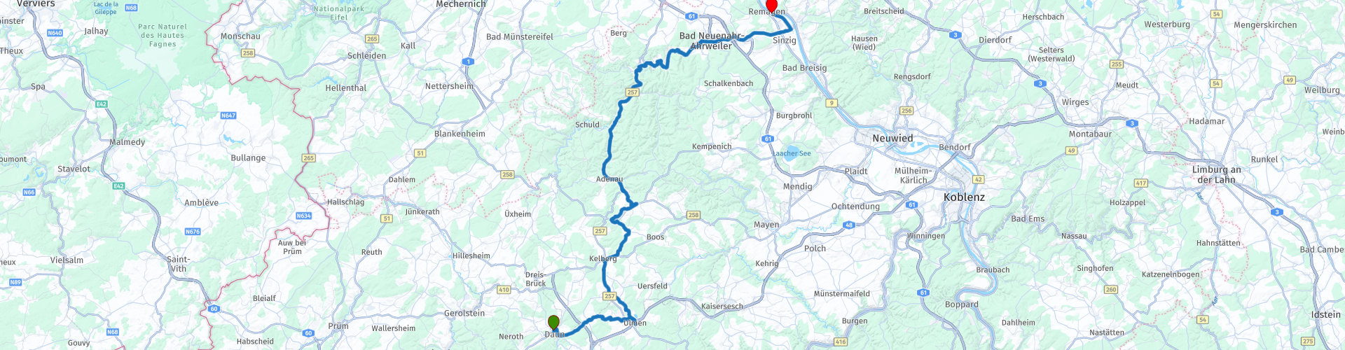
 Arrival: Remagen
This is the third of three stages through the High Eifel. They are all short stages, which offer you plenty of opportunity to visit sights. The route is almost 100 km long.
The roads of this ride are perfectly passable, but sometimes winding and steep up to Altenahr. Then you have now arrived in the Ahr valley and you gradually notice that the altitude becomes lower; As the Rhine Valley approaches, the roads become much less winding and eventually flat and straight.
The great variety, fantastic roads, views and picturesque places give the ultimate holiday feeling, so this route gets 5 stars.
 Share this route


Animation

Verdict


Duration
7h 5m

Mode of travel
Car or motorcycle

Distance
96.91 km

Countries

 RouteXpert Review
 The tourist town of Daun, picturesquely situated on the right bank of the Lieser, consists of two separate centres: Unter- and Oberdaun. (If you have not yet seen the Maare (crater lakes) of Daun, it is worthwhile to drive past them. You then go south until just before Gemünden and then follow the signs on the left).
You leave (Ober)Daun from the parking lot next to the cinema. Maybe first refuel and then head southeast under the new A1 highway, via Darscheid to the medieval town of Ulmen. After a city fire in 1831, stones from the castle were used to rebuild the town, but the castle has been in ruins ever since. Yet it is one of the oldest castles in the Eifel. You have a magnificent view of the town and the surrounding hills. The Saint Matthias Church was built in neo-Romanesque-Gothic style. Another attraction is the Ulmener Maar, the youngest volcanic crater lake in the Eifel, formed about 11,000 years ago. Gas bubbles are still rising from the bottom of the lake. Swimming is prohibited here. A little further north lies a very old Maar, the Jungferweiher Maar. A very special visit to the Ulmener Stollen, an underground gallery in a tunnel that connects both Maare (see link Ulmener Stollen).
Kelberg is a nice village with actually a cozy village square, where you can drink a delicious cup of coffee at the bakery on the terrace in the park. The village is located in a small valley in the highest part of the Eifel and surrounded by extensive coniferous forests.
Then it continues driving on the excellent, but winding roads through the forests and along the green slopes. Unfortunately, that dream is soon interrupted because the Nürburgring is located between Kelberg and Adenau.
When you think of the Eifel you think of peace and nature, but the Eifel is also popular with motor sports enthusiasts. The legendary Nürburgring circuit has been there since 1927, the year the race track opened. You come here to view all branches of motorsport and to race around the circuit with your own car or motorcycle. But today it is quiet on the circuit. In any case, Nürburg Castle is still there. After a visit, you can continue the tour quietly. Soon the picturesque Adenau will appear.
Adenau is surrounded by mountains; the Hüstert (406 meters), the Kirchberg (447 meters) and the Breite Heide (496 meters). And of course De Hohe Acht. This is the highest mountain in the Eifel with a height of 747 meters. In Adenau there is a beautiful historic market with a source that used to provide the city's water supply. Then there is also the historic Botermarkt district. There and around the market are beautiful authentic half-timbered houses. Some of these stately half-timbered houses date from the 14th century. You can certainly go shopping, enjoy a bite to eat and drink or sit on a terrace here. From Adenau the picturesque places follow in quick succession.
Altenahr is very beautiful just to walk around because it still has parts that date back to the Middle Ages. There are still old fortress walls and gate turrets. Walking through narrow streets with picturesque half-timbered houses, you will feel like you are in another time. It is also known for its viticulture. It is therefore a popular tourist place with cozy alleys and beautiful half-timbered houses. Here you will find wine bars and you can taste the Ahr wine. Well worth a visit! In short, Altenahr is increasingly becoming a tourist attraction that mainly lives from tourism and wine growing.
The walled town of Ahrweiler is the medieval part of the larger municipality of Bad Neuenahr-Ahrweiler. The historic core is actually a large open-air museum. If you come to Ahrweiler as a visitor, you are expected to park your car outside the historic village center. There are several parking spaces where you can park your car for a fee just outside the perfectly intact city walls. The Altstadt is only open to local traffic.
Remagen is a very old city on the Rhine. In the center is the Romanesque-Gothic St Peter and Paul Church and a Roman museum. The Romanesque gate at the cemetery is decorated with reliefs. The gravestones around the church mainly date from the seventeenth and eighteenth centuries. Outside the center is the Apollinaris Church on a hill with a crypt from the fourteenth century.
Remagen is also known from the Second World War. The railway bridge at Remagen was the only bridge that was still intact when the Americans wanted to cross the Riin. However, previous German attempts to blow up the bridge had weakened the Remagen Bridge. The Americans could use the bridge for ten days. Then the Ludendorff Bridge collapsed. The bridge was never rebuilt.


 Links
Links  Usage
Usage Want to download this route?
You can download the route for free without MyRoute-app account. To do so, open the route and click 'save as'. Want to edit this route?
No problem, start by opening the route. Follow the tutorial and create your personal MyRoute-app account. After registration, your trial starts automatically.  Disclaimer
Use of this GPS route is at your own expense and risk. The route has been carefully composed and checked by a MyRoute-app accredited RouteXpert for use on TomTom, Garmin and MyRoute-app Navigation.
Changes may nevertheless have occurred due to changed circumstances, road diversions or seasonal closures. We therefore recommend checking each route before use.
Preferably use the route track in your navigation system. More information about the use of MyRoute-app can be found on the website under 'Community' or 'Academy'.

Rheinland Pfalz
About this region
Rhineland-Palatinate (German: Rheinland-Pfalz, [ˈʁaɪ̯nlant ˈp͡falt͡s] (listen)) is a western state of Germany. It covers 19,846 km2 (7,663 sq mi) and has about 4.05 million residents. It is the ninth largest and sixth most populous of the sixteen states. Mainz is the capital and largest city. Other cities are Ludwigshafen am Rhein, Koblenz, Trier, Kaiserslautern and Worms. It is bordered by North Rhine-Westphalia, Saarland, Baden-Württemberg and Hesse and by the countries France, Luxembourg and Belgium.
Rhineland-Palatinate was established in 1946 after World War II, from parts of the former states of Prussia (part of its Rhineland province), Hesse and Bavaria (its former outlying Palatinate kreis or district), by the French military administration in Allied-occupied Germany. Rhineland-Palatinate became part of the Federal Republic of Germany in 1949 and shared the country's only border with the Saar Protectorate until the latter was returned to German control in 1957. Rhineland-Palatinate's natural and cultural heritage includes the extensive Palatinate winegrowing region, picturesque landscapes, and many castles and palaces.
Read more on Wikipedia
Rhineland-Palatinate was established in 1946 after World War II, from parts of the former states of Prussia (part of its Rhineland province), Hesse and Bavaria (its former outlying Palatinate kreis or district), by the French military administration in Allied-occupied Germany. Rhineland-Palatinate became part of the Federal Republic of Germany in 1949 and shared the country's only border with the Saar Protectorate until the latter was returned to German control in 1957. Rhineland-Palatinate's natural and cultural heritage includes the extensive Palatinate winegrowing region, picturesque landscapes, and many castles and palaces.
View region
 Statistics
  140
140Amount of RX reviews (Rheinland Pfalz)
 48078
48078Amount of visitors (Rheinland Pfalz)
 27841
27841Amount of downloads (Rheinland Pfalz)
 Route Collections in this region
 Top 5 Car and Motorcycle Routes in the Eifel
The Eifel is the eastern part of the medium plateau Eifel-Ardennes. It is located north of the Moselle and west of the Rhine. The largest part is in Germany, a small part is in Belgium, in the East Cantons. The German part of Eifel is located in the federal states of North Rhine-Westphalia and Rhineland-Palatinate. The highest point is the Hohe Acht with 747 meters.
Several chains can be distinguished in the Eifel:
The northernmost part is called the Nordeifel, which in Belgium connects to the High Fens;
To the east of this is the Ahrgebirge, this part is located north of the Ahr in the Ahrweiler district;
South of the Ahr is the Hohe Eifel (or Hocheifel), of which the Hohe Acht (747 m) is the highest point, and also the highest point in the entire Eifel region;
To the west, near the Belgian border, the hills are known as Schneifel, part of the wider Snow Eifel area with peaks reaching up to 698 metres;
South and east of the Hohe Eifel is the Volcano-Eifel, a volcanic area with many crater lakes (Maare).
The southern part of the Eifel is less high. The area is bisected by streams and rivers running southwards. These streams flow into the Moselle. The largest of these rivers is the Kyll; the hills around this river are known as the Kyllwald;
In the south, the Eifel ends in the Voreifel.
In the north of the Eifel there are some large reservoirs. The largest of these is the reservoir in the Roer that was created by the construction of the Roerdal dam.
The Nürburgring is also located in the Eifel, a well-known car circuit for Formula 1 races, among other things. Since 2004, part of the north of the Eifel has become the Eifel National Park. This National Park falls entirely within the German-Belgian nature park High Fens-Eifel. Another part of the Eifel falls within the South Eifel Nature Park.
Well-known throughout the Netherlands and Belgium by car and motorcyclists, so reason enough for the MyRoute app RouteXpert to compile a Top 5 of Car and Motorbike routes for you.
All routes in this collection have been checked and made equal for TomTom, Garmin and MyRoute-app Navigation by a MyRoute-app RouteXpert.
If you think, I have a very nice route that should certainly not be missing from this collection, send it to:
email: routeexpert@myrouteapp.com
Subject: New Route for the Top 5 collection Eifel composed by Hans van de Ven.
The route will then be reviewed and then added to the Top 5. To make the Top 5 also the Top 5, 1 route will have to disappear from the Top 5, you can indicate this when submitting the new route.
Have fun with this collection and while driving one of these routes. Enjoy all the beauty that the Eifel has to offer. Click on “View route” to read the review of the chosen route.
I would like to hear your findings about the route(s).
View Route Collection
Route collection hairpins in the Eifel
This collection is composed of the most beautiful and winding roads in the Eifel. Forget Bundesstraßen, forget the road along the Moselle, if you have driven these roads, you can really say that you have been to the Eifel.
No less than 6 routes and 1,800 kilometers are waiting for you!
No less than 6 routes and 1,800 kilometers are waiting for you!
View Route Collection