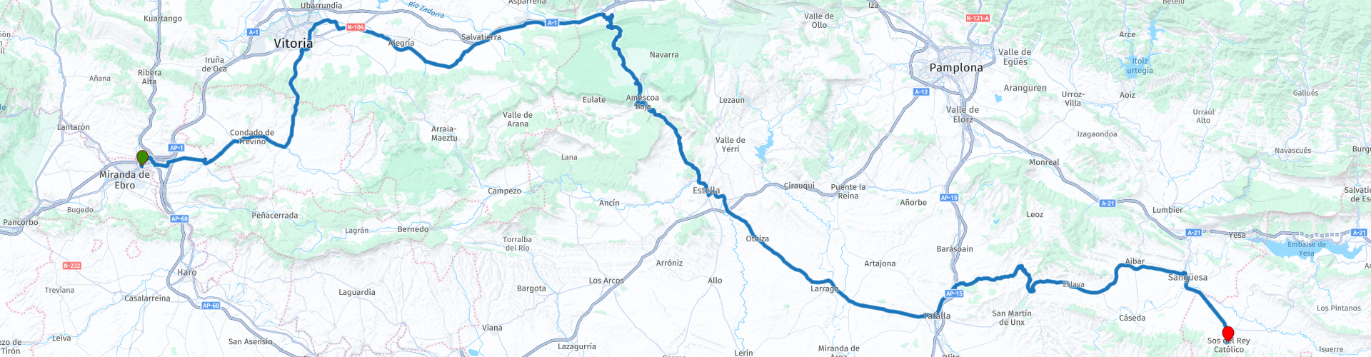
04 Miranda de Ebro to Sos del Rey Catolico

This route was brought to you by:
RouteXpert Nick Carthew - (MRA Master)
Last edit: 04-04-2025
 Route Summary
  Share this route


Animation

Verdict


Duration
6h 56m

Mode of travel
Car or motorcycle

Distance
220.81 km

Countries

 RouteXpert Review
 On leaving the hotel, you can't help noticing the silhouette of a large bull by the roadside. The image of the Osborne bull in Spain is widely recognized, as of July 2022 there are 92 of them installed on hilltops and along roadways throughout much of Spain. The bull was originally conceived as an outdoor advertisement for the Brandy de Jerez made by the Osborne Group in 1956. With the passage of time, the Osborne bull has become a national symbol of Spain.
When we did this tour in 2016, we passed field after field of wheat, so this is obviously the grain growing area of Spain.
We stopped in Vittoria to visit a Burger King for a quick coffee and to buy some provisions for a picnic from the Carrefour Market.
After Vittoria you are soon on pleasant rural roads heading towards the Parque Natural de Urbasa-Andia at Olazaguti.
You can then see the higher ground as you approach and the road gets steeper and twistier the further you go with several hairpin bends. We stopped on one of these bends for a photo and we saw Griffon Vultures soaring overhead as well as Peregrine Falcons. Once you have ascended the limestone cliff, there is a plateau with shady beech trees providing an excellent spot to stop for your picnic. The higher altitude and shade from the trees meant that we could cool off and chat about all those hairpins we had just ridden!
On the far side of the plateau you can park up to visit the Mirador de Ubaba. A 500m walk takes you to the Pilatos Balcony or Ubaba viewpoint. The cliff or precipice forms a semi-circular rock circus 300 meters high. The cliff walls are the habitual habitat of vultures and white vultures and the views are breathtaking.
Then what goes up must come down and so you are treated to more twisties as you descend. You reach the small village of Zudaire which is actually built around 2 beautifully swooping hairpin bends!
Gradually the route transforms, the temperature (if you are riding in summer) increases as you reach the vast open plains we decided to stop for a refreshing drink in Estella, a town of great monumental and religious heritage on the Camino de Santiago. Aymeric Picaud, author of the Pilgrim's, wrote of Estella that, 'Estella is a city of good bread, great wine, lots of meat and fish, and all kinds of happiness'. Founded in 1090 by King Sancho Ramirez, the town is a wonderful destination for lovers of art, history and monumental heritage. Parking was easy and there were bars on the other side of the road.
The roads become straighter but there is a charm to the countryside with the route bordered by wheat fields with poppies. An hour or so later and we found refuge from the heat in Sanguesa with its streets of very tall stone buildings providing shaded tables and bars with refreshing, tangy, homemade lemonade with lots of ice. The end destination of Sos del Rey Católico (a fortified hilltop village) is just 15 minutes away and soon becomes visible as it is perched on top of a hill, like an island in the flat plain. Charming place for an overnight stop with narrow streets to walk, bars and restaurants. As it is a walled town you have to park outside and walk into the medieval centre but it is not much of a hardship as the architecture is stunning in it’s antiquity. Our B&B for the night was The Infanzon which was small but very comfortable and a good breakfast in the morning. A link to the B&B is below.
Enjoy


 Links
Links  Usage
Usage Want to download this route?
You can download the route for free without MyRoute-app account. To do so, open the route and click 'save as'. Want to edit this route?
No problem, start by opening the route. Follow the tutorial and create your personal MyRoute-app account. After registration, your trial starts automatically.  Disclaimer
Use of this GPS route is at your own expense and risk. The route has been carefully composed and checked by a MyRoute-app accredited RouteXpert for use on TomTom, Garmin and MyRoute-app Navigation.
Changes may nevertheless have occurred due to changed circumstances, road diversions or seasonal closures. We therefore recommend checking each route before use.
Preferably use the route track in your navigation system. More information about the use of MyRoute-app can be found on the website under 'Community' or 'Academy'.

Navarre
About this region
Navarre (English: ; Spanish: Navarra [naˈβara]; Basque: Nafarroa [nafaro.a]), officially the Chartered Community of Navarre (Spanish: Comunidad Foral de Navarra [komuniˈðað foˈɾal de naˈβara]; Basque: Nafarroako Foru Komunitatea [nafaro.ako foɾu komunitate.a]), is an autonomous community and province in northern Spain, bordering the Basque Autonomous Community, La Rioja, and Aragon in Spain and Nouvelle-Aquitaine in France. The capital city is Pamplona (or Iruñea in Basque). The present-day province makes up the majority of the territory of the medieval Kingdom of Navarre, a long-standing Pyrenean kingdom that occupied lands on both sides of the western Pyrenees, with its northernmost part, Lower Navarre, located in the southwest corner of France.
Navarre is in the transition zone between Green Spain and semi-arid interior areas, and thus its landscapes vary widely across the region. Being in a transition zone also produces a highly variable climate, with summers that are a mix of cooler spells and heat waves, and winters that are mild fir the latitude. Navarre is one of the historic Basque districts: its Basque features are conspicuous in the north, but virtually absent on the southern fringes. The best-known event in Navarre is the annual San Fermín festival held in Pamplona in July.
Read more on Wikipedia
Navarre is in the transition zone between Green Spain and semi-arid interior areas, and thus its landscapes vary widely across the region. Being in a transition zone also produces a highly variable climate, with summers that are a mix of cooler spells and heat waves, and winters that are mild fir the latitude. Navarre is one of the historic Basque districts: its Basque features are conspicuous in the north, but virtually absent on the southern fringes. The best-known event in Navarre is the annual San Fermín festival held in Pamplona in July.
View region
 Statistics
  10
10Amount of RX reviews (Navarre)
 21558
21558Amount of visitors (Navarre)
 581
581Amount of downloads (Navarre)
 Route Collections in this region
 Ten Day Roadtrip from Spain to Portugal
This route collection describes a 10-day Road trip in the north of Spain and Portugal, a true paradise for motorcycling.
You drive over beautiful mountain ridges and through beautiful valleys. Along the way you drive through beautiful villages and countless nature reserves, great passes with countless curves, tunnels cut out of the mountains and azure blue reservoirs. The roads are fair to good, sometimes unpaved.
What you get to see along the way;
Spanish Pyrenees
Parc Naturel del Cadi-Moixero
Serra del Cadí
Serra de Moixeró
Pedraforca
Serra del Monsec
Collada de Clarà
Parque Nacional de Ordesa y Monte Perdido
Collados del Asón Natural Park.
Parque natural Saja-Besaya
Parque natural de Fuentes Carrionas y Fuente Cobre
Parque natural de la Montana de Riano y Mampodre
Picos de Europa
El Parque regional Montaña de Riaño y Mampodre
El Parque natural de Redes
The Sierra de la Culebra
Parque natural Montesinho
Along the routes there are more than enough nice places to stop for a short or longer period, these are described in the review and with a waypoint and POI included in the routes.
Have fun reading and planning your next motorcycle vacation.
If you have ridden these routes I would like to hear your feedback.
View Route Collection
The 10 most downloaded routes in Spain from RouteXpert Rene Plucken
Hello and welcome to this collection of the Top 10 MyRoute app downloaded routes in Spain>.
There will be a great new event to be announced soon, where all these routes can be ridden.
Download them all now and place them in a new "Top 10" folder, so that you always have them at hand.
If you are going to drive one of these routes in the meantime, track them with the MRA Mobile App or with MRA Navigation. Take some photos (moments) along the way as these will come in handy.
Create a travelstory of your Top 10 driven routes and add the recorded track to it.
There will also be some great prizes on offer, so keep an eye on the MRA-RouteXperts page and your email.
The 10 routes are:
1. el Pont de Suert to Sabinanigo
2. Figueres to Coll de Nargo
3. Villacarriedo to Potes
4. Caldes to Jaca
5. Jaca to Bilbao
6. Roundtrip Picos
7. Girona to Peramola
8. Peramola to Caldes
9. Guernica to Villacarriedo
10. Sabinanigo to Gernica
View Route Collection