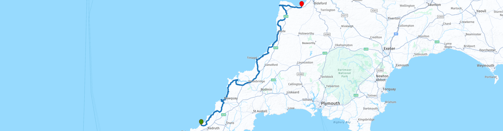
08 Portreath to Bideford via Padstow and Tintagel

This route was brought to you by:
RouteXpert Nick Carthew - (MRA Master)
Last edit: 17-10-2022
 Route Summary
 A coastal route using some small roads but offering you breathtaking views of the North Cornwall and Devon coasts. Visit a tin mine still producing tin, a world class surfing beach, lunch stop in Padstow, Tintagel Castle the legendary birthplace of King Arthur, Museum of Witchcraft and Magic, a secret radar station, and the smugglers playground at Hartland Quay.
This route thoroughly deserves the 5***** stars that I have awarded.
 Share this route


Animation

Verdict


Duration
6h 53m

Mode of travel
Car or motorcycle

Distance
170.27 km

Countries

 RouteXpert Review
 This route starts by taking you around the perimeter of RRH Portreath, a Remote Radar Head operated by the Royal Air Force. The sophisticated radar here provides long-range coverage of the south western approaches to the UK. You won’t see much as it’s all a bit hush hush!
Set in narrow winding valley flanked by impressive granite cliffs is the seaside village of Porthtowan. You'll have great views over the village and out to sea as you climb the hill on the way to St Agnes.
St Agnes (or Aggie as it’s affectionately known) is in a designated Area of Outstanding Natural Beauty (AONB) and is a popular spot for tourists who enjoy the rugged landscape. Up until the 1920’s St Agnes was a centre for the mining of tin, copper, and arsenic. The instantly recognisable remains of the tin mines that are silhouetted against the horizon speak of the industrial heritage of this area. The re-purposed Wheal Kitty mine can be seen soon after leaving Aggie, now known as the Wheal Kitty Workshops after the conversion to small industrial workshops.
The route now takes you by the Blue Hills Tin Streams, the only mine in Cornwall still producing tin today. You can visit the shop to buy some Cornish tin to take home and remind you of the mining heritage of this part of Cornwall.
Next is Cornwall's surf city, Newquay (it's actually a large town).
Fistral Beach at Newquay is one of the world’s top surfing destinations, backed by high cliffs and sand dunes; Fistral is the playground for hundreds of enthusiasts who flock to the beach to get a fix of the big waves. All the big UK surf competitions take place here including the Famous Night Surf, Boardmasters Surf Championships, National Surf Championships, the Groms plus many more. The car park next to the beach offers you some great views of the Atlantic Ocean.
From here the route heads to Padstow and on the way you'll pass the long sheltered bay of Porth, the little-known but never forgotten village of Mawgan Porth and then Porthcothan Bay, known for its smuggling before arriving at Padstow on the River Camel estuary for lunch.
Padstow is a charming working fishing port surrounded by glorious sandy beaches, at the head of the Camel River. Watching the everyday ebb and flow of harbour life is a perfect way to spend an hour or two. This foodie destination with popular eateries such as Rick Stein’s Seafood Restaurant and fish and chip shop have been a magnet for tourists for years. It balances a working fishing fleet with being a top visitor destination, famous as a high-end foodie hotspot. During the 19th century, the port flourished with the pilchard industry at its height. Shipbuilding became a major industry, with six working shipyards in Padstow at one point. The railway brought tourism to Padstow in 1899. The Atlantic Express ran a regular service between London and Padstow. Since then the town has never looked back and although the fishing industry still survives, there is little doubt what Padstow's main industry is these days.
A 40 minute ride from Padstow takes you to the mystical village of Tintagel where legend has it; King Arthur was born!
Tintagel Castle:
Built half on the mainland and half on a jagged headland projecting into the Cornish sea, Tintagel Castle is one of the most spectacular historic sites in Britain. Its association with King Arthur makes it also one of the most famous. But the history of this enigmatic place stretches back centuries before the first tales of the legendary king shrouded it in the mists of romance. To visit the castle and to fully take in it's history, you would need to spend a few hours there, that probably isn't possible while using this route, however, this route takes you to the Camelot Castle Hotel where you have great views of the castle and island and the new walkway bridge.
From Tintagel, the coastal village of Boscastle is just 4 miles away.
One of the most scenic villages on Cornwall's north coast, Boscastle has a postage-stamp sized harbour built to handle trade in slate from the nearby Delabole quarries. The quay was built in the Elizabethan period and has hardly been altered since. It helps protect the harbour, once one of the busiest in north Cornwall. Because the Cornish coast was such a dangerous place until the 19th century, boats would put in to Boscastle rather than attempt a dangerous landing elsewhere. Cornwall has long had an association with legends, myths, and magic. Part of the reason why Cecil Williamson set up his amazing Museum of Witchcraft and Magic here was due to the fact that Boscastle had a history of witches or cunning folk. The witches of Boscastle were in the business of ‘selling the wind’ to sailors on the harbour. They would capture the wind in three knots of rope and sailors would buy them in order for the wind to capture their sails. The weather charm was untied and then the wind would blow the sailors on their way. There is free motorcycle parking opposite the Cobweb Inn, park up and have a look around and maybe visit the Museum of Witchcraft and Magic!
Continue your journey and more narrow lanes that have some breathtaking sea views take you further up the coast past Crackington Haven and Millook and on to Widemouth Bay, there is a very good cafe next to the beach here where you can park your motorcycle outside and enjoy a coffee while taking in the beautiful coastline.
After your coffee stop, the route will take you through the coastal town of Bude and onto the secret listening station on the former World War II airfield, RAF Cleave. The giant radar dishes tell you that something hush hush is going on here.
Known as GCHQ Bude, the station comprises twenty one satellite antennas of various sizes, including three that have a diameter of 30 m (100 ft). These giant satellite dishes overlooking the beach is home to some of the most high-tech digital security and intelligence operations in the world and regularly performs tasks which prevent terrorism, combat organised crime and keep not just the UK but the World safe. The operatives regularly work alongside MI5 and the Secret Intelligence Service (MI6) to thwart threats to national security. There are CCTV cameras everywhere and signs on the fence stating no photography. I didn't see the signs when I took photos :)
The last stop on this route is across the county border and back into Devon. Turn off of the A39 and head over Bursdon Moor. One of the last remaining areas of Culm Grassland can be found on this moor which has SSSI status (Site of Special Scientific Interest). This high open moorland has far reaching spectacular views over moor, woodland and coastline stretching as far as the eye can see. On the high ground of Bursdon Moor there are nine barrows, or burial mounds, which form part of a widespread group of prehistoric monuments in the Hartland area. The narrow road takes you to St Nectan's Church in the village of Stoke. The sheer scale of the church, and its striking tower, has given it the nickname 'The Cathedral of North Devon'. It's an apt description, for the tower is a local landmark, easily visible for miles around. The church we see today was built in 1360. Its most obvious feature is the eye-catching tower, erected around 1420 and standing 128 feet high, the tallest church tower in Devon. More practically, it was used as an aid to navigation by sailors along the treacherous North Devon coast. You'll soon be descending the steep, narrow and twisty road that will take you to Hartland Quay.
The spectacular cliffs at Hartland Quay with their incredibly contorted rock layers are always worth a visit.
About 300 million years ago, during a period of tectonic plate collision, tremendous pressure was exerted on the rocks of South West England. So powerful were these forces that the rocks were actually compressed like a concertina, producing a range of spectacular folds and faults that are visible today. The area is part of an Area of Outstanding Natural Beauty, Site of Special Scientific Interest and Special Area of Conservation. So I think we can safely say, Hartland Quay is special!
Hartland Quay was built towards the end of the 16th Century being one of many quays along the coast. A pier of very similar construction can still be seen in Clovelly to this day. Heavy goods such as lime, slate and coal were shipped in from across the Bristol Channel and local produce such as barley and oats would have been shipped out. With the arrival of the railway in Bideford, maintenance of the pier ceased and by 1896 the greater part of the pier had been destroyed by storms. In 1970, access to the sea was once again established, albeit for much smaller craft, when members of the Hartland Boat Club constructed the present slipway.
The buildings were converted into a hotel and pub at the end of the 19th Century. The buildings that are now the existing pub were once the malthouse and stables with hay lofts above, with the cottages opposite for the workers.
Although countless ships have been wrecked on this coast through the centuries, the first wreck that the Hartland Quay Coastguard were known to have attended came in January 1860. This was the start of many ships running aground here and before the turn of the Century fifteen more vessels were to become wrecks on Hartland’s “tempest furrowed shore”. You can explore the history of Hartland Quay and it’s spectacular coastline inside the Hartland Quay Museum.
The hotel at the end of the route is only 20 minutes from the Quay, so if you have time, you could turn off at Clovelly Cross roundabout (10 minutes from hotel) and visit the privately owned fishing village of Clovelly.
Clovelly is an ancient fishing village that clings to the cliffs above Bideford Bay. It was made famous by Charles Kingsley, the author of ‘Westward Ho!’, whose salty tale about pirates and adventure sparked a boom in Victorian tourism. A walk down the steep cobbled street isn’t for the faint hearted. But the harbour views and seeing the cute houses is worth it.
The route ends at The Hoops Inn, a thatched, 13c coaching inn with a fabulous garden and good car park. Even though I only live a few miles away, I stayed here with a group of friends who were visiting from the Netherlands. The rooms, restaurant and staff were all very nice. The next route in this road trip is a round tour of Exmoor National Park so book two nights at The Hoops.
Enjoy.


 Links
Links  Usage
Usage Want to download this route?
You can download the route for free without MyRoute-app account. To do so, open the route and click 'save as'. Want to edit this route?
No problem, start by opening the route. Follow the tutorial and create your personal MyRoute-app account. After registration, your trial starts automatically.  Disclaimer
Use of this GPS route is at your own expense and risk. The route has been carefully composed and checked by a MyRoute-app accredited RouteXpert for use on TomTom, Garmin and MyRoute-app Navigation.
Changes may nevertheless have occurred due to changed circumstances, road diversions or seasonal closures. We therefore recommend checking each route before use.
Preferably use the route track in your navigation system. More information about the use of MyRoute-app can be found on the website under 'Community' or 'Academy'.

South West
About this region
The points of the compass are an evenly spaced set of horizontal directions (or azimuths) used in navigation and geography. A compass rose is primarily composed of four cardinal directions—north, east, south, and west—each separated by 90 degrees, and secondarily divided by four ordinal (intercardinal) directions—northeast, southeast, southwest, and northwest—each located halfway between two cardinal directions. Some disciplines such as meteorology and navigation further divide the compass with additional azimuths. Within European tradition, a fully defined compass has 32 'points' (and any finer subdivisions are described in fractions of points).Compass points are valuable in that they allow a user to refer to a specific azimuth in a colloquial fashion, without having to compute or remember degrees.
Read more on Wikipedia
View region
 Statistics
  42
42Amount of RX reviews (South West)
 24657
24657Amount of visitors (South West)
 3766
3766Amount of downloads (South West)
 Route Collections in this region
 Great 6 day tour of Wales
This collection of 6 routes all pass through at least 1 of the 3 spectacular national parks of Wales'. Each park is unique and individual and the landscapes vary from the vast, remote and wide open moorland of the Brecon Beacons to the rugged mountains and glistening lakes of Snowdonia and the spectacular coastline of the Pembrokeshire coast. Each is a delight to travel through and these routes will take you to some of the best beauty spots.
There are some great attractions to visit too, as well as having more than it's fair share of fantastic castles and historic buildings, there is the worlds fastest zip line, a balcony road used for world rally stages, mysterious caves and magical waterfalls and a museum of land speed records. All of these can be seen on the routes in this collection.
Although each route in this collection is a separate stand alone route, they will all link up seamlessly to make a 6 day tour that you will remember. The tour starts and ends in Gloucester which can be easily reached in a day from any of the Channel ports.
Enjoy Wales.
View Route Collection
Top 10 Downloaded UK routes by RouteXpert Nick Carthew
Hello and welcome to this collection of the Top 10 MyRoute app downloaded routes in the UK.
There will be a great new event to be announced soon, where all these routes can be ridden.
Download them all now and place them in a new "Top 10" folder, so that you always have them at hand.
If you are going to drive one of these routes in the meantime, track them with the MRA Mobile App or with MRA Navigation. Take some photos (moments) along the way as these will come in handy.
Create a travelstory of your Top 10 driven routes and add the recorded track to it.
There will also be some great prizes on offer, so keep an eye on the MRA-RouteXperts page and your email.
View Route Collection