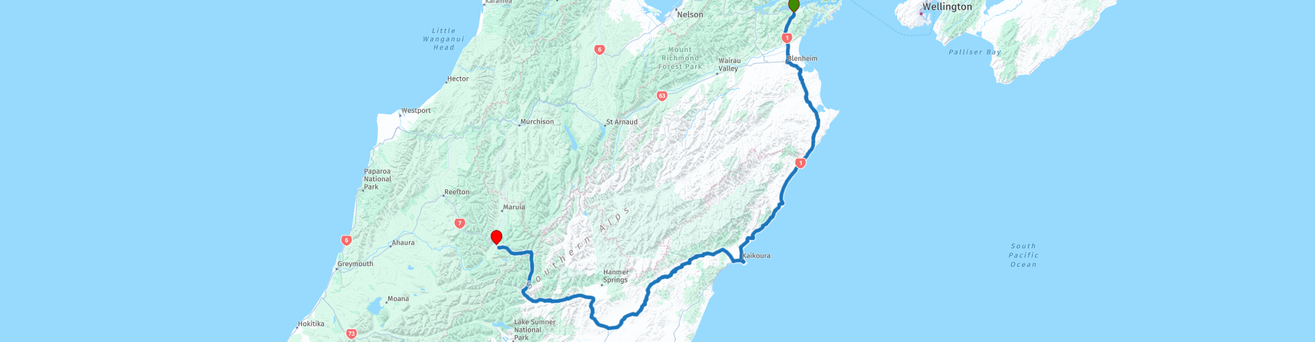
01 Picton to Springs Junction

This route was brought to you by:
RouteXpert Nick Carthew - (MRA Master)
Last edit: 09-03-2021
 Route Summary
  Share this route


Animation

Verdict


Duration
6h 51m

Mode of travel
Car or motorcycle

Distance
361.63 km

Countries

 RouteXpert Review
 Leaving Picton with a full tank of fuel, you'll soon be passing through the Para Wetlands. The skeletons of dead willows you will see are part of the conservation efforts to return this wetland to its natural state. Fish and Game, licenced by the NZ government have poisoned most of the willows and a restoration plan is underway to revegetate the remaining wetlands in native species. The poisoning campaign was not without controversy as it has left large numbers of dead willows which are impractical to remove but will remain for some years to come until they decay naturally. The 122 hectare wetland between Tuamarina and Koromiko is the largest natural wetland in the region. Returning the wetland to its former state has increased waterfowl and fish populations, as well as native tree regrowth, and improved water quality.
You'll then pass Lake Grassmere to your left, this has been used for salt production since 1943. Seawater, fresh from the Pacific Ocean, is pumped into Lake Grassmere. Warm north-west winds blow across the exposed lake, evaporating water and increasing the concentration of salt. The very salty water is pumped into deep holding pens, then into shallow crystallisation ponds. As the water continues to evaporate, salt forms as a crust on the bottom of the ponds. The remaining water is pumped out and the dried salt is harvested, crushed, washed and moved by giant conveyor belts to form huge mounds of sparkling white crystals.
You'll soon see the sparkling South Pacific Ocean as you travel further south on State Highway 1 and then follow it for approximately 40 kms, all the way south to the Kaikoura peninsula. There's a great lookout on the peninsular and is certainly worth a visit. he peninsula has been settled by Maori for approximately 1000 years, and by Europeans since the 1800s, when whaling operations began off the Kaikōura Coast. Since the end of whaling in 1922 whales have been allowed to thrive and the region is now a popular whale watching destination.
You'll start to head inland now on the rather aptly named 'Inland Road'! This is a fantastic road with lots of twists and turns and even some hairpins through this hilly landscape, the straighter sections just beg you to open the taps a little bit. I've suggested a lunch stop towards the end of this road at a small town called Waiau, you can fill with fuel again here too.
From 1919 until 1978, Waiau was the terminus of the Waiau Branch, a branch line railway that ran to the town from a junction with the Main North Line in Waipara. There were proposals to extend this line beyond Waiau as part of the Main North Line and some 3 kms of formation was made for a route to Kaikoura, but construction ground to a halt and a coastal route via Parnassus and Hundalee was chosen for the Main North Line instead. Waiau was heavily impacted by the 2016 Kaikoura earthquake as the epicenter was just 15 kms away. In 2021 the town still bears many scars from the earthquake.
Waiau shares its name with several much smaller settlements and farming communities within New Zealand. The name is Maori, and means flowing water, the Waiau River is on the edge of town.
After lunch you'll soon be on the Lewis Pass road, another fantastic road where the hills slowly transform into mountains. The Hanmer Range can be seen after passing the junction for Hanmer Springs. The tallest peak in the range is Miromiro, standing tall at 1875 m and often snow capped. The route has taken on a more alpine feel about it now and there's a great opportunity to stretch your legs and take in the magnificent views as you approach the top of the Lewis Pass road. Look out for the St James Walkway sign on your right, I have placed a pink route point and parking POI here to highlight it. This review's header photo shows you what to expect.
The regional border from from Canterbury to West Coast is also here and just a few hundred metres further is the highest point of the Lewis Pass and this route.
You are approaching the end of this route now at Springs Junction. The remoteness of this area means accommodation is spread out. There is an Hotel, campsite and motel on this road before you reach the end of this route at a motel in Springs Junction, I have included links below for all four. The first you'll reach is the Maruia Springs Thermal Resort and as the name suggests, you can receive all types of treatments here and they also have glamping and camping pitches.
Enjoy.


 Links
Links  Usage
Usage Want to download this route?
You can download the route for free without MyRoute-app account. To do so, open the route and click 'save as'. Want to edit this route?
No problem, start by opening the route. Follow the tutorial and create your personal MyRoute-app account. After registration, your trial starts automatically.  Disclaimer
Use of this GPS route is at your own expense and risk. The route has been carefully composed and checked by a MyRoute-app accredited RouteXpert for use on TomTom, Garmin and MyRoute-app Navigation.
Changes may nevertheless have occurred due to changed circumstances, road diversions or seasonal closures. We therefore recommend checking each route before use.
Preferably use the route track in your navigation system. More information about the use of MyRoute-app can be found on the website under 'Community' or 'Academy'.