Wandelen op de Sallandse heuvelrug vanuit Haarle

This route was brought to you by:
RouteXpert Hans Lamers - RouteXpert
Last edit: 11-03-2025
 Route Summary
 We walk this route regularly. A beautiful piece of nature where you can enjoy in peace.
For me a rating of 4 stars.
 Share this route


Animation

Verdict


Duration
2h 43m

Mode of travel
By foot

Distance
9.47 km

Countries

 RouteXpert Review
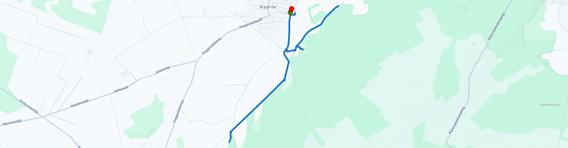
 You take your first steps in the picturesque village of Haarle, where the morning dew still lies like a wafer-thin veil over the fields. The air is fresh, filled with the scent of pine needles and moist earth. Today you walk over the Sallandse Heuvelrug, a rolling landscape full of stories, past old trees and quiet heathlands.
The first few kilometres take you slowly uphill. The path winds between the hills and every now and then you catch a glimpse of the vast heathlands, which would be in full bloom in August. The birds whistle their morning song and somewhere in the distance you hear a woodpecker tapping vigorously against a tree trunk.
Then the Palthe tower appears.
Palthe lived in Almelo and owned the land around the hill, where he hunted regularly. In 1898 he had a tea house built where people could recover from hunting and possibly stay with a few people.
In the years that followed, he had architect Karel Muller design various extensions, such as the gallery and the tower.
Palthe, who founded the Palthe textile factories with two brothers, was very interested in the latest techniques and applied them in the country house.
The house was completely self-sufficient with its own water well and American windmill to generate electricity.
The house also had a pool with a bathhouse. This building still exists, it is called the witches' house by the inhabitants of nearby Haarle.
Initially the house was intended as a hunting and holiday home, but later Palthe moved there himself.
The tower offers a wide view of the landscape. You can climb up there and let your gaze wander over the forests and hills that stretch to the horizon. Here you really feel how grand and at the same time peaceful nature is.
With light legs you continue your route, slowly descending through a mix of deciduous and coniferous forests. The smell of resin and damp leaves accompanies you, while your footsteps are muffled by the soft sandy path.
Around noon you reach Herberg De Pas. The wooden facade and thatched roof give the building a cozy appearance. Inside, the fire crackles softly, but on a sunny day you naturally choose a spot outside. A well-filled sandwich or a cup of home-made soup tastes even better here after a few hours of brisk walking.
After lunch you walk back towards Haarle. The route takes you along another side of the Sallandse Heuvelrug, with again breathtaking views and quiet paths where you feel like you are alone in the world. The afternoon sun casts long shadows over the path and every now and then a squirrel shoots away into the bushes.
Finally you arrive back in Haarle, where you look back with a satisfied feeling on a wonderful walk. Your lungs full of fresh air, your head empty of worries - exactly as a day in nature should be.


 Links
Links  Usage
Usage Want to download this route?
You can download the route for free without MyRoute-app account. To do so, open the route and click 'save as'. Want to edit this route?
No problem, start by opening the route. Follow the tutorial and create your personal MyRoute-app account. After registration, your trial starts automatically.  Disclaimer
Use of this GPS route is at your own expense and risk. The route has been carefully composed and checked by a MyRoute-app accredited RouteXpert for use on TomTom, Garmin and MyRoute-app Navigation.
Changes may nevertheless have occurred due to changed circumstances, road diversions or seasonal closures. We therefore recommend checking each route before use.
Preferably use the route track in your navigation system. More information about the use of MyRoute-app can be found on the website under 'Community' or 'Academy'.