02 Villages from Huelva Aracena to Rio Tinto Mines

This route was brought to you by:
RouteXpert Jordi Honrubia MRA-RouteXpert
Last edit: 14-02-2025
 Route Summary
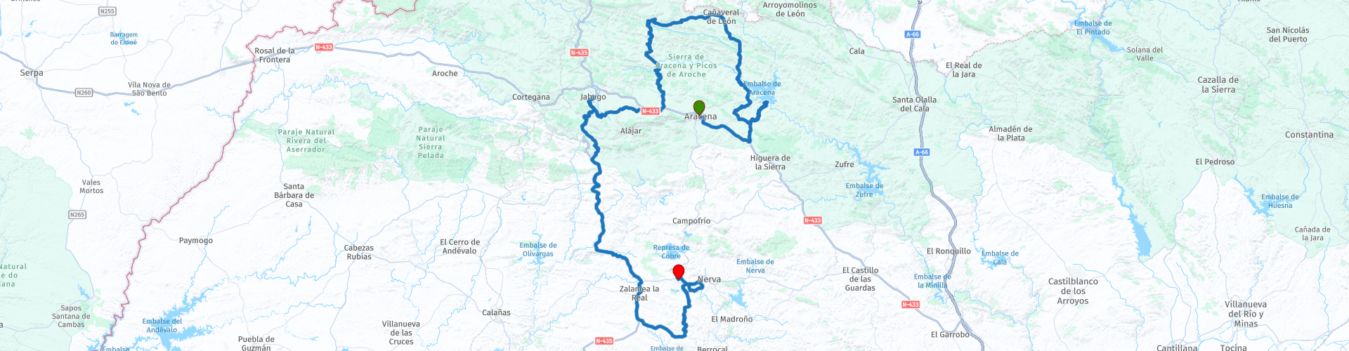
 The province of Huelva in southwestern Andalusia offers an enriching experience on this second route. It starts in Aracena, a town full of history, nature and traditions.
The Serranía de Aracena and the Picos de Aroche are known for their biodiversity. The winding roads offer spectacular views and each bend reveals new charms of nature. Some of the mountain roads are narrow and twisty with no edge protection and the surface can be uneven in places, there is also a short 6km stretch of gravel road which is easy to navigate but this only adds to the sense of adventure as you travel through these remote but beautiful areas.
"Local gastronomy, stunning scenery and scenic roads make this route a unique experience in Spain. I definitely give it 5 stars!"
 Share this route


Animation

Verdict


Duration
7h 36m

Mode of travel
Car or motorcycle

Distance
160.57 km

Countries

 RouteXpert Review
 Welcome to the route that will take you through stunning landscapes, charming villages and a rich history in the province of Huelva.
On our second route through the villages of Huelva we will continue to delight and enjoy ourselves
From our senses in all aspects of pleasure.
We depart from Aracena :
Regional capital located in the heart of the Sierra. Aracena is today an active city that perfectly combines its tourist attractions with the role it plays as a service centre for the entire region. Highlights include the rich gastronomy, its important historical-artistic and natural heritage (Grotto of Wonders), the varied traditional festive programme, completed by a cultural offer rich in high-quality current content, and the abundant offer of tourist accommodation, make Aracena and its villages privileged places to spend a few days to enjoy and always remember.
Jabuguillo:
It was erected on the old road that led to Seville and its name comes from the diminutive of the Galician-Leonese term xabugo/sabugo that designates a plant, the elderberry.
It is characterized by a landscape of pastures where the popular architecture of white houses and cobbled streets stands out. The church of Nuestra Señora del Rosario is its main heritage element. This temple has a single nave with transverse arches. It was built in the eighteenth century on a podium that crosses the steep slope of the street where it is located. On the outside, the neoclassical style façade stands out. It preserves traditional washhouses in the main square.
Aracena Reservoir:
It is the reservoir at the head of the Rivera de Huelva River, of the gravity type with buttresses. It entered service in 1970. Its dam is located in the municipality of Puerto Moral and has a capacity of 128.6 hm³ and a regulation volume of 39 hm³.
It has a receiving basin with an area of 408 km². The regulation elements are: five Taintor-type spillway gates, two bottom drains and two regulators, as well as an outlet through the Hydroelectric Power Plant with 4,570 kW of installed power, which came into service in 1990.
Hinojales:
Walk through the streets of Hinojales and enjoy strolling through its white streets. Explore the Church of Nuestra Señora de Consolación, a 15th-century Andalusian Gothic-Mudejar style building, recognized as an Asset of Cultural Interest. Inside, you will discover outstanding fresco mural paintings from the 15th and 16th centuries. Just behind you can enjoy the incredible mountain views offered by the viewpoint.
You cannot leave without visiting the Hermitage of Nuestra Señora de Tortola, a small baroque building inside which there is an early Christian tombstone and the Virgin of Tortola, an anonymous work from Seville from the sixteenth century. In his honour, the patron saint festivities are celebrated in May, where the traditional dance of our town is of special interest.
Aracena and Picos de Aroche:
Located at the western end of the Sierra Morena and in the north of the province of Huelva, the Sierra de Aracena and Picos de Aroche Natural Park is characterised by an extensive forest mass, high rainfall, a mild climate and a natural and cultural heritage that arouses the curiosity and interest of the visitor.
The large pastures that predominate in this mountain environment have favoured the breeding of the Iberian pig, around which an industry has been built that sustains the economy of towns such as Cumbres Mayores or Jabugo. You should not leave the place without trying its exquisite sausages and, of course, its ham with Denomination of Origin Huelva. At the Aracena Ham Museum you can learn more about the sausage tradition of the area.
The landscape changes depending on the altitude and humidity. The pastures populated by holm oaks are replaced by cork oaks in some areas, while in the higher altitudes forests of oak oaks are frequent, such as in the area of Solana de los Bonales; on the other hand, in towns such as Fuenteheridos, Galaroza or Castaño del Robledo the landscape is made up of chestnut trees; and in riverbeds such as the Múrtigas through gallery forests where large trees such as poplars, ashes, willows and alders abound, along with brambles and climbing plants. The latter environment provides an ideal resting place for the visitor.
This forest variety provides an interesting wealth of fauna. Inside the park it is possible to observe mammals such as the mongoose, the genet or the elusive otter. The birdlife is also diverse; Crossing the skies of this natural environment, you can see, among others, vultures, kites and black storks. A good option to get to know this natural heritage up close is to take walking routes along one of its signposted trails or take a quiet horseback ride.
Touring its villages and enjoying its interesting heritage is an unmissable event for visitors to the park. You can visit the monumental complex of Almonaster la Real, made up of the castle, the church and the mosque, the castle of Cortegana, one of the best preserved in the area or the fortress of Sancho IV in Cumbres Mayores. Another possibility is to enter the Grotto of Wonders in Aracena or visit the Peña de Arias Montano in Alájar, which are two attractions of undoubted natural interest.
On the other hand, the region also offers a varied gastronomic offer: game meats, goat cheese, cured meats and, of course, chestnuts, which are prepared in all their varieties. One of its culinary products, mushrooms, brings together mycology lovers every year in conferences and courses, inviting them to recognize them and learn about their properties, being possible to enjoy this delicacy during the harvest season.
Cortelazor:
Village located in the center of the mountains, within the judicial district of Aracena, whose urban center is declared an Asset of Cultural Interest; and in which the Parish Church of Our Lady Sra.de Los Remedios and the old Hermitage of the Virgin of the Crowned stand out.
Its municipal area belongs to the Sierra de Aracena and Picos de Aroche Natural Park, one of the most important protected areas in the Community and which occupies the entire north of the province with its pastures and small elevations covered, predominantly, with forests of holm oaks, cork oaks, chestnut trees and scrubland, through which numerous streams flow, forming a landscape of extraordinary beauty and attractiveness.
Its History From Roman times, some remains have been found near the Sanctuary of Our Crowned Lady.
Its name comes from the Court of King Azor, a lord who took over these lands after the dismemberment of the Caliphate of Cordoba and the formation of the kingdoms of Taifas in the period of Al-Andalus.
The Christian conquest was carried out by Alfonso X the Wise and belonged to the province of Seville until the creation of the province of Huelva in 1833.
Philip IV granted it the title of Villa in 1631.
Jabugo:
Village located in the Sierra de Aracena and Picos de Aroche Natural Park, one of the most important protected areas in the Community and which occupies the entire north of the province with its pastures and small elevations covered, predominantly, with forests of holm oaks, cork oaks, chestnut trees and scrubland, through which numerous streams flow, forming a landscape of extraordinary beauty and attractiveness, ideal for livestock, especially for the Iberian pig, which finds ideal conditions here, ideal for livestock, especially for the Iberian pig, which finds ideal conditions here.
To talk about Jabugo is to talk about the capital of ham and Iberian pork cured meats, as it has been the main producer of such exquisite delicacies since ancient times. But it also offers other elements of interest such as the Church of San Miguel (Asset of Cultural Interest), the Cueva de la Mora or the Calf.
The history of Jabugo has been linked to that of Almonaster until, in the seventeenth century, Don Luis Márquez de Avellaneda, lord of Almonaster, gives his consent for it to become independent.
A few years later, Charles II granted it its own jurisdiction.
Our End of the Route will be The Rio Tinto Mines:
A mining town of ancient origin but of modern construction since the current town was built by the Mining Company at the beginning of the century to take advantage of the wealth that was in the subsoil of the previous one.
Its urban structure responds to a rational model, whose greatest exponent is the Bellavista neighborhood, an example of a colonial building of English origin that housed the company's staff.
In its landscape, telluric and mysterious, the mining exploitations stand out, today abandoned and used for tourist enjoyment. Some, such as Corta Atalaya, are of great spectacularity. It currently has a very interesting initiative: the Mining Train, which runs along the route that the mineral followed.
The history of this mining town, its iron, silver and copper mines have been exploited for about five thousand years. Tartessians, Phoenicians benefited from the riches of these lands.
In Roman times the exploitation of mines reached its greatest peak, it was also quite paralyzed from the fall of the Roman Empire until the seventeenth century.
In the nineteenth century came the revitalization with the arrival of the English. It would continue with some ups and downs until 1954 when they passed back into Spanish hands.
A trip through the Riotinto mining basin in Huelva is a unique experience that places us at times in the past and at times on another planet. Enjoy landscapes reminiscent of Mars, board a nineteenth-century railway, marvel at the colors of a river unique to the presence of copper and iron in the water and discover all kinds of curiosities in its History of the Mines of Riotinto
To know the history of the mining basin we must look back 5,000 years, since the Bronze Age is the origin of this exploitation. Then came the Tartessians, the Phoenicians, the Carthaginians and finally the Romans. The latter worked the basin intensively in search of copper, silver and iron many centuries before us. Vestiges of its presence have reached our days and you will find in the Mining Museum.
After years without significant activity, it was sold to England by the State at the end of the nineteenth century, where the Rio Tinto Company Limited was in charge of a massive exploitation over almost a century that completely changed the physiognomy of the mine. The railway was implemented to facilitate the method of work, houses and even a hospital were built and English traditions were established in the Huelva social panorama of the mid-twentieth century, customs that endure to this day.
But, above all, there are two things that attract attention and make it stand out worldwide. The first, the fact that it is one of the oldest mines in the world. The second is that it has attracted NASA itself to study the peculiar ecosystem and biodiversity that is generated in its waters by the presence of metals and the little oxygen present: although it may seem like science fiction, similarities with the planet Mars have been found in Riotinto.
What to see in the mining basin of Riotinto,
The Ernest Lluch Mining Museum:
The starting point for understanding the mine and its significance in history is this museum, located in the restored building of the former British hospital. What will we discover in it? The history of the different civilizations that exploited the basin through its 17 rooms.
Here you can tour the interior of a Roman mine and discover the objects necessary for mining over the years, as well as learn the geological secrets of this peculiar subsoil.
Several rooms highlight the importance of the railway in the day-to-day mining in Riotinto during the nineteenth century, hence the recreation of various vintage train carriages that will surely excite the youngest members of the family.
Watchtower Cut:
Speechless is how you would be left if you could visit this large crater, the product of one of the largest open-pit mining operations in Europe, which remains closed to the public. The fact of knowing that it originated by human hands does not detract from the beauty of this photogenic lunar landscape: 1,200 meters in diameter at its widest part and 345 meters deep that descend in steps and spirals to an intense dark red water.
Peña de Hierro
Peña de Hierro is the name given to the mine that has been exploited since Roman times, although it experienced its boom with the British from the mid-nineteenth to the mid-twentieth century. Visiting it is a unique immersion in the world of mining, as you cross 200 meters of underground gallery until you reach the open-pit mine, much less spectacular than Corta Atalaya, but equally interesting for the landscape that characterizes the entire mining park.
Riding the mining train:
Without a doubt, the mining railway of Riotinto is the number one tourist attraction. In the past it was used as a work tool, and the tracks connected directly with the Port of Huelva. Little remains today of the 300 kilometres of route network and more than 3,300 wagons and wagons, but it is possible to get an idea of the route in old restored wagons on a 22-kilometre journey (round trip) following the course of the river, with strategic stops to get to know the mine's ecosystem up close.
British Heritage: The 21st House:
From the English presence in Huelva originated a Victorian colony, Bella Vista, where the directors of the Rio Tinto Company Ltd. lived. Today only this house, known as Casa 21, remains, which preserves in detail the furniture and furnishings of the late nineteenth century. Visiting it connects us directly with the British way of life in Huelva, with its habits and customs.
Discover the Gossán reservoir:
Finally, to finish the visit we approach this large reservoir that connects Riotinto with the town of Campofrío and is closely related to the mine. It has mining waste that gives it a peculiar yellowish colour and was declared an Asset of Cultural Interest in 2005.
Moon Train:
This railway is none other than the one that makes the usual route of the visit to the Mining Park of Riotinto, but at a very special moment. Because the Moon Train leaves with the last light of day, during the summer, to return at night to the starting point, with no more illumination than that reflected by our satellite.
At the end of this review, there is nothing left but to rest in this authentic and special Pueblo Minas De Río Tinto, Province of Huelva, Huelva, Andalusia, and close your eyes and know that you will not forget this route for having enjoyed so many things.


 Links
Links  Usage
Usage Want to download this route?
You can download the route for free without MyRoute-app account. To do so, open the route and click 'save as'. Want to edit this route?
No problem, start by opening the route. Follow the tutorial and create your personal MyRoute-app account. After registration, your trial starts automatically.  Disclaimer
Use of this GPS route is at your own expense and risk. The route has been carefully composed and checked by a MyRoute-app accredited RouteXpert for use on TomTom, Garmin and MyRoute-app Navigation.
Changes may nevertheless have occurred due to changed circumstances, road diversions or seasonal closures. We therefore recommend checking each route before use.
Preferably use the route track in your navigation system. More information about the use of MyRoute-app can be found on the website under 'Community' or 'Academy'.

Andalusia
About this region
Andalusia (UK: , US: ; Spanish: Andalucía [andaluˈθi.a]) is the southernmost autonomous community in Peninsular Spain. It is the most populous and the second largest autonomous community in the country. It is officially recognised as a "historical nationality". The territory is divided into eight provinces: Almería, Cádiz, Córdoba, Granada, Huelva, Jaén, Málaga, and Seville. Its capital city is Seville. The seat of the High Court of Justice of Andalusia is located in the city of Granada.
Andalusia is located in the south of the Iberian peninsula, in southwestern Europe, immediately south of the autonomous communities of Extremadura and Castilla-La Mancha; west of the autonomous community of Murcia and the Mediterranean Sea; east of Portugal and the Atlantic Ocean; and north of the Mediterranean Sea and the Strait of Gibraltar. Andalusia is the only European region with both Mediterranean and Atlantic coastlines. The small British overseas territory of Gibraltar shares a three-quarter-mile land border with the Andalusian portion of the province of Cádiz at the eastern end of the Strait of Gibraltar.
The main mountain ranges of Andalusia are the Sierra Morena and the Baetic System, consisting of the Subbaetic and Penibaetic Mountains, separated by the Intrabaetic Basin. In the north, the Sierra Morena separates Andalusia from the plains of Extremadura and Castile–La Mancha on Spain's Meseta Central. To the south the geographic subregion of Upper Andalusia lies mostly within the Baetic System, while Lower Andalusia is in the Baetic Depression of the valley of the Guadalquivir.The name "Andalusia" is derived from the Arabic word Al-Andalus (الأندلس). The toponym al-Andalus is first attested by inscriptions on coins minted in 716 by the new Muslim government of Iberia. These coins, called dinars, were inscribed in both Latin and Arabic. The etymology of the name "al-Andalus" has traditionally been derived from the name of the Vandals. Since the 1980s, a number of proposals have challenged this contention. Halm, in 1989, derived the name from a Gothic term, *landahlauts,
and in 2002, Bossong suggested its derivation from a pre-Roman substrate. The region's history and culture have been influenced by the Tartessos, Iberians, Phoenicians, Carthaginians, Greeks, Romans, Vandals, Visigoths, Byzantines, Berbers of North Africa, Jews, Romani, Arab Umayyads, and Moors. During the Islamic Golden Age, Cordoba surpassed Constantinople to be Europe's biggest city, and became the capital of Al Andalus and a prominent center of education and learning in the world, producing numerous philosophers and scientists. The Castilian and other Christian North Iberian nationalities reconquered and settled the area in the latter phases of the Reconquista.
Andalusia has historically been an agricultural region, compared to the rest of Spain and the rest of Europe. Still, the growth of the community in the sectors of industry and services was above average in Spain and higher than many communities in the Eurozone. The region has a rich culture and a strong Spanish identity. Many cultural phenomena that are seen internationally as distinctively Spanish are largely or entirely Andalusian in origin. These include flamenco and, to a lesser extent, bullfighting and Hispano-Moorish architectural styles, both of which are also prevalent in some other regions of Spain.
Andalusia's hinterland is the hottest area of Europe, with cities like Córdoba and Seville averaging above 36 °C (97 °F) in summer high temperatures. Late evening temperatures can sometimes stay around 35 °C (95 °F) until close to midnight and daytime highs of over 40 °C (104 °F) are common. Seville also has the highest average annual temperature in mainland Spain and mainland Europe (19.2 °C, 66.6 °F), closely followed by Almería (19.1 °C, 66.4 °F).
Read more on Wikipedia
Andalusia is located in the south of the Iberian peninsula, in southwestern Europe, immediately south of the autonomous communities of Extremadura and Castilla-La Mancha; west of the autonomous community of Murcia and the Mediterranean Sea; east of Portugal and the Atlantic Ocean; and north of the Mediterranean Sea and the Strait of Gibraltar. Andalusia is the only European region with both Mediterranean and Atlantic coastlines. The small British overseas territory of Gibraltar shares a three-quarter-mile land border with the Andalusian portion of the province of Cádiz at the eastern end of the Strait of Gibraltar.
The main mountain ranges of Andalusia are the Sierra Morena and the Baetic System, consisting of the Subbaetic and Penibaetic Mountains, separated by the Intrabaetic Basin. In the north, the Sierra Morena separates Andalusia from the plains of Extremadura and Castile–La Mancha on Spain's Meseta Central. To the south the geographic subregion of Upper Andalusia lies mostly within the Baetic System, while Lower Andalusia is in the Baetic Depression of the valley of the Guadalquivir.The name "Andalusia" is derived from the Arabic word Al-Andalus (الأندلس). The toponym al-Andalus is first attested by inscriptions on coins minted in 716 by the new Muslim government of Iberia. These coins, called dinars, were inscribed in both Latin and Arabic. The etymology of the name "al-Andalus" has traditionally been derived from the name of the Vandals. Since the 1980s, a number of proposals have challenged this contention. Halm, in 1989, derived the name from a Gothic term, *landahlauts,
and in 2002, Bossong suggested its derivation from a pre-Roman substrate. The region's history and culture have been influenced by the Tartessos, Iberians, Phoenicians, Carthaginians, Greeks, Romans, Vandals, Visigoths, Byzantines, Berbers of North Africa, Jews, Romani, Arab Umayyads, and Moors. During the Islamic Golden Age, Cordoba surpassed Constantinople to be Europe's biggest city, and became the capital of Al Andalus and a prominent center of education and learning in the world, producing numerous philosophers and scientists. The Castilian and other Christian North Iberian nationalities reconquered and settled the area in the latter phases of the Reconquista.
Andalusia has historically been an agricultural region, compared to the rest of Spain and the rest of Europe. Still, the growth of the community in the sectors of industry and services was above average in Spain and higher than many communities in the Eurozone. The region has a rich culture and a strong Spanish identity. Many cultural phenomena that are seen internationally as distinctively Spanish are largely or entirely Andalusian in origin. These include flamenco and, to a lesser extent, bullfighting and Hispano-Moorish architectural styles, both of which are also prevalent in some other regions of Spain.
Andalusia's hinterland is the hottest area of Europe, with cities like Córdoba and Seville averaging above 36 °C (97 °F) in summer high temperatures. Late evening temperatures can sometimes stay around 35 °C (95 °F) until close to midnight and daytime highs of over 40 °C (104 °F) are common. Seville also has the highest average annual temperature in mainland Spain and mainland Europe (19.2 °C, 66.6 °F), closely followed by Almería (19.1 °C, 66.4 °F).
View region
 Statistics
  20
20Amount of RX reviews (Andalusia)
 22452
22452Amount of visitors (Andalusia)
 453
453Amount of downloads (Andalusia)
 Route Collections in this region
 A 4 day tour in Spain from Bilbao to Cartagena
With a starting point just south of Bilbao, this 1,300 km tour is easy to connect to from the French border or Santander. The tour travels through some of Spain's most spectacular landscapes and visits among other things, the windmills of La Mancha, made famous in the books by Miguel de Cervantes and his character Don Quixote. The end of this 4 day tour is at Cartagena on the Mediterranean's Costa Cálida, a wonderful city that's alive with culture, history and gastronomy.
View Route Collection
Discovering the villages of Huelva
This tour consists of three routes for three days, but you can do them interchangeably if you prefer due to the proximity of the three routes. Huelva is an area to explore, beautiful in its landscapes and nature and the best thing is its Iberian pork gastronomy and on these routes you can experience and enjoy it all.
View Route Collection