04 Urgup to Sivas via Kayseri

This route was brought to you by:
RouteXpert Yannis Papadiotis (wheelboy)
Last edit: 22-11-2025
 Route Summary
 Turkey isn’t just a country, it’s a rider’s playground. This is the 4th of 12 stage journey takes you from Aegean coastlines through mountains, plains, and fairytale valleys all the way to the Black Sea and back west again.
Each leg has its own flavor, so here’s a deeper look.
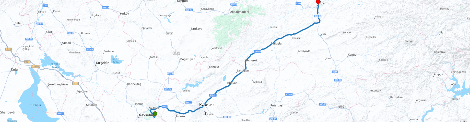
Route 4:
From Ürgüp to Sivas, this route crosses Anatolia’s high plains, blending smooth highways with cultural and scenic highlights. Early stops include Saruhan Caravanserai and Kayseri Castle, where Seljuk walls meet modern life. Along the way, you may pass Lake Tuzla and another Sultanhanı, both quiet reminders of the Silk Road. Those seeking more adventure can take a 50 km off-road detour through Karakuz, Kaymak, and Kazancık, riding beside a river through untouched nature before rejoining the D260 toward Sivas. The day ends in a city rich with Seljuk heritage.
I vote this route with 4* because offers a perfect mix of comfort, history, and optional exploration.
 Share this route


Animation

Verdict


Duration
5h 21m

Mode of travel
Car or motorcycle

Distance
270.49 km

Countries

 RouteXpert Review
 Just a few kilometres further and you can stop for more photographs at The Saruhan Kervansaray, built in 1249/1259 under Seljuk rule and served as a major stop along the Silk Road. Today it’s also known for its evening Whirling Dervish Ceremony, held within the great hall, creating a compelling blend of historical architecture and spiritual performance. Opening hours: 09:00 to 23:00 General entry is free but in evening event of Whirling Dervish Ceremony there is a ticket around 25-30€.
A whirling dervish ceremony, also known as a sema, is a traditional Sufi ritual of spiritual meditation performed by the Mevlevi Order. The ceremony involves dervishes spinning in a meditative trance, a practice that symbolizes the dancers' journey toward God by shedding their ego.
As you travel across the Anatolian highlands towards the city of Kayseri a very prominent snow capped peak grows larger and larger on the horizon, this is Erciyes Dağı, or Mount Erciyes, a massive, extinct stratovolcano in Central Anatolia standing as the region's highest peak 3,917 meters.
In the city of Kayseri you can visit Kayseri Castle, dates back to Roman times and was expanded by the Byzantines, Seljuks, and Ottomans. Its well preserved stone walls and towers surround a historic courtyard with cultural displays and local shops. Just beside it lies the Kayseri Covered Bazaar (Kapalı Çarşı) one of Anatolia’s oldest, featuring hundreds of shops selling carpets, spices, copperware, and regional delicacies in an authentic atmosphere making this a great place to stop for a coffee.
After leaving Kayseri you have 3 route options as you head towards Sivas.
The first option is just a 10 minute ride:
Turn left to visit Lake Tuzla or Lake Palas Tuzla, a nice deviation with just few extra kilometres more. The lake offers unique visual landscapes shimmering salt flats, open skies and bird watching opportunities is a nature stop in a broader Central Anatolia route.
The second option is even closer, just 500 metres from the route:
Turn left to visit Sultanhan Kervanseray, another caravanserai or historic roadside inn that provided lodging, food, and water for travellers, often found along routes like the Silk Road. These establishments were vital hubs for trade and cultural exchange, typically built around a central courtyard with rooms, stables, and other amenities like mosques, baths, and markets.
The third option gives you a chance to ride 50 kilometres off-road:
Turn left and follow the POIs. If you are looking for some adventure along this route you can take this deviation and ride some off-road along the river and in nature. This deviation is about 50 kilometres and almost 1 hour of riding. The route is thru Karakuz, Kaymak and Kazancık villages before you return on D260.
The route ends in historic city of Sivas, known for its rich cultural heritage, beautiful landscapes, and delicious local cuisine.


 Links
Links  Usage
Usage Want to download this route?
You can download the route for free without MyRoute-app account. To do so, open the route and click 'save as'. Want to edit this route?
No problem, start by opening the route. Follow the tutorial and create your personal MyRoute-app account. After registration, your trial starts automatically.  Disclaimer
Use of this GPS route is at your own expense and risk. The route has been carefully composed and checked by a MyRoute-app accredited RouteXpert for use on TomTom, Garmin and MyRoute-app Navigation.
Changes may nevertheless have occurred due to changed circumstances, road diversions or seasonal closures. We therefore recommend checking each route before use.
Preferably use the route track in your navigation system. More information about the use of MyRoute-app can be found on the website under 'Community' or 'Academy'.

Kayseri
About this region
Kayseri (Turkish pronunciation: [ˈkajseɾi]; Greek: Καισάρεια) is a large industrialised city in Central Anatolia, Turkey. It is the seat of Kayseri Province. The city of Kayseri, as defined by the boundaries of Kayseri Metropolitan Municipality, is structurally composed of five metropolitan districts, the two core districts of Kocasinan and Melikgazi, and since 2004, also Hacılar, İncesu and Talas.
As of the 31 December 2019 estimation, Kayseri Province had a population of 1,407,409 inhabitants whom 1,144,265 lived in the built-up area made of four (out of five) urban districts, İncesu not being conurbated yet.
Kayseri is located at the foot of the inactive volcano Mount Erciyes that towers 3,916 metres (12,848 feet) over the city. The city is often cited in the first ranks among Turkey's cities that fit the definition of Anatolian Tigers.The city retains a number of historical monuments, including several from the Seljuk period. While it is generally visited en route to the international tourist attractions of Cappadocia, Kayseri has many attractions in its own right: Seljuk and Ottoman era monuments in and around the city centre, Mount Erciyes as a trekking and alpinism centre, Zamantı River as a rafting centre, and the historic sites of Kültepe, Ağırnas, Talas and Develi. Kayseri is served by Erkilet International Airport and is home to Erciyes University.
Read more on Wikipedia
As of the 31 December 2019 estimation, Kayseri Province had a population of 1,407,409 inhabitants whom 1,144,265 lived in the built-up area made of four (out of five) urban districts, İncesu not being conurbated yet.
Kayseri is located at the foot of the inactive volcano Mount Erciyes that towers 3,916 metres (12,848 feet) over the city. The city is often cited in the first ranks among Turkey's cities that fit the definition of Anatolian Tigers.The city retains a number of historical monuments, including several from the Seljuk period. While it is generally visited en route to the international tourist attractions of Cappadocia, Kayseri has many attractions in its own right: Seljuk and Ottoman era monuments in and around the city centre, Mount Erciyes as a trekking and alpinism centre, Zamantı River as a rafting centre, and the historic sites of Kültepe, Ağırnas, Talas and Develi. Kayseri is served by Erkilet International Airport and is home to Erciyes University.
View region
 Statistics
  1
1Amount of RX reviews (Kayseri)
 152
152Amount of visitors (Kayseri)
 2
2Amount of downloads (Kayseri)
 Route Collections in this region
 Riding Across Turkey Route by Route
This route collection offers a complete journey across Turkey, combining iconic landmarks with diverse landscapes.
Starting from the Aegean coast, you explore Ephesus and Pamukkale before heading inland to Lake Salda and Sagalassos. Cappadocia forms a highlight with its unique rock formations and underground cities. The route then crosses central Anatolia’s wide plains toward the rugged east, where quieter roads and dramatic scenery dominate. A major contrast follows along the Black Sea, with green mountains and coastal views. The return west through Bursa and Pergamon adds rich history.
Overall, this is a well balanced itinerary ideal for travelers seeking variety, culture, and scenic driving.
View Route Collection