06A George Knysna Uniondale Adventure

This route was brought to you by:
RouteXpert René Plücken (MRA Master)
Last edit: 15-12-2025
 Route Summary
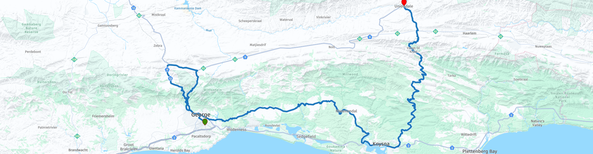
 This is a scenic drive from George via some beautiful, challenging unpaved mountain passes with challenging turns to Uniondale. It's over 226 kilometers.
Because this route includes several unpaved gravel roads, a suitable motorcycle, quad bike, or 4x4 is recommended. Some experience driving on these types of roads is essential.
For those who prefer not to drive on unpaved roads, there's another route that only uses paved roads. The paved road route (06 George Knysna Uniondale) is also included in the RouteXpert library; the link can be found in this review.
Along the route there are opportunities to stop and enjoy the beautiful views and there is the opportunity to explore Knysna.
Enjoy this beautiful ride which I rate with 5 stars.
 Share this route


Animation

Verdict


Duration
11h 14m

Mode of travel
Car or motorcycle

Distance
226.72 km

Countries

 RouteXpert Review
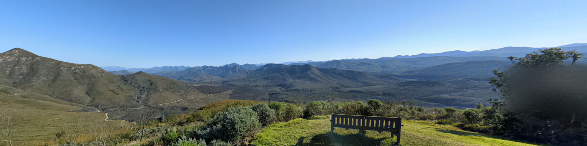
 The pass was built between 1942 and 1951 as a modern alternative to the older, narrow, unpaved, and steep Montagu Pass (which we'll drive back to George later) and offers much greater traffic capacity. It has 40 bends, giving you views of the four different passes in the area: Robinson Pass, Swartberg Pass, Meiringspoort, and Montagu Pass. These four passes are also visible from "The 4 Passes" viewpoint. This is a popular spot for tourists to admire the diverse mountain scenery. We'll also stop here to take photos.
After the pass, we stop for a short break at the Roadside Deli Stall, known for its pizzas, bread, and other delicious dishes fresh from the oven. We then drive via the R62 to Camfer, where the Montagu Pass begins. This was the first road between George and Oudtshoorn, opened in 1848 after three years of construction by some 250 convicts at a cost of £36,000. The pass claims to be the oldest, unaltered pass still in use in South Africa and comprises 17.1 km of beautifully scenic, narrow gravel roads with 126 bends, ascending from the small hamlet of Herold over the crest of the Outeniqua Mountains and then descending all the way to the outskirts of George.
We'll stop at the old tollhouse at the foot of the Outeniqua Pass. Enjoy the best pancakes and coffee, and then explore the interesting museum with a good overview of the history and breathtaking views of the surrounding mountains. A perfect spot to relax with stunning views.
After the scenic drive through the Outeniqua Pass, we'll return to George, where you can have lunch. As we leave George, another highlight awaits us: the Seven Passes Road, a historic and scenic route in South Africa's Western Cape province, begins here. The Seven Passes Road is a 75-kilometer journey along seven gorges carved deeply by rivers flowing to the sea. Legendary engineer Thomas Bain designed the road in 1883.
This route connects George and Knysna via seven mountain passes: Phantom Pass, Homtini Pass, Karatara Pass, Hoogekraal Pass, Touw River Pass, Silver River Pass, and Kaaimansgat Pass. Originally designed and built by Thomas Bain with the help of his brother-in-law Adam de Smidt, the route is renowned for its scenic beauty, historical significance, and dense forests.
Thomas Charles John Bain was a South African road builder. A pioneer in road construction, Bain was responsible for the planning and construction of over 900 km of roads and mountain passes, many of which are still in use, during a career spanning from 1848 to 1888. These passes, traversing the mountain ranges between the narrow coastal plain and the interior of the former Cape Colony in South Africa, played a significant role in opening up South Africa's vast hinterland.
The Seven Passes Road begins and ends on asphalt, but most of the route is unpaved. While most motorcycles and cars can handle the entire road, heavy rain and some sections of the route can be disrupted. It's a good idea to bring some snacks, water, or a cold drink. If you're driving the route in summer, bring your swimsuit and towels to cool off in one of the many streams.
Kaaimansgat Pass is the first of the seven passes. This winding, curving asphalt road leads through lush indigenous forest to the area's famous Blackwater rivers. The road is old, narrow, and the asphalt is in poor condition. The pass has an old bridge (a national monument) that's worth stopping for a few photos. Although the pass is relatively short at 2.8 km, it has many sharp bends, and drivers are advised to keep their speed below 40 km/h. The only safe place to stop is on either side of the bridge, where there are two small parking areas.
The next pass is the Silver River Pass, a 2.7-kilometer-long, narrow, winding asphalt road through dense native forests, descending to and from the Silver River, starting where the Kaaimansgat Pass ends and ending at the picturesque Wilderness Heights. The road is a national monument and was constructed around 1882 by Adam de Smidt. The pass is the second official pass from west to east. Many people consider the Kaaimansgat and Silver River Passes as one continuous pass because they flow seamlessly into one another. The pass has similar key features to the Kaaimansgat Pass: it is almost the same length and has an elevation gain of 86 meters. The difference lies in the number of bends in the Silver River Pass. It has 30 bends, which averages out to one bend every 90 meters!
The next pass is the Touw River Pass. The road was constructed around 1883 by Adam de Smidt. This gravel road remains virtually unchanged from its original route, with one exception: the original wooden bridge washed away. It was replaced by a steel bridge in the 1900s. The pass has similar characteristics to the Kaaimansgat and Silver River Passes. It is 2.5 km long and has an elevation change of 92 m, with the same inverted vertical profile characteristic of a pass that descends through a river gorge and emerges on the other side. Of the seven rivers crossed by the 7 Passes Road, the Touw River is the largest and most prone to flooding.
The next pass is the Hoogekraal Pass, a 3-kilometer stretch offering breathtaking views along the narrow gravel road. This pass descends to and from Hoogekraal, ending just before the Geelhoutsvlei sawmill. Like the Kaaimansgat, Silver River, and Touw River passes, this pass shares very similar characteristics in terms of distance and elevation gain, as well as the classic inverted profile of a pass descending to a river and emerging on the other side. This is the first of seven passes to have a bridge wide enough for two lanes of traffic. All the bridges are constructed of concrete and stone and designed in the Victorian style of the early 1900s. Only the steel bridge over the Touw River differs.
The next pass is the Karatara Pass, directly behind the forest village of the same name. As with all gravel roads in rainy areas, the usual warning "slippery in rain" applies here. The road surface is rough and corrugated, which can lead to loss of grip and control, especially on bends, so drive carefully. Like all the previous passes, this one has similar statistics, with a length of 2.6 km and a slightly smaller elevation gain of 62 m. The vertical profile is again the classic inverted shape of a pass that begins at a high point, then descends to a river crossing, before ascending again to almost the same altitude as the starting point.
The next pass is the narrow, gravelly Homtini Pass, with 5 km of beautifully scenic roads. The pass descends to the river from which it takes its name and climbs up on the eastern side, ending at the Rheenendal Timber Mill. The name is apparently of Khoi origin and means "mountain honey" or "difficult passage." This pass is also known as the Goukamma River Pass. At 5 km, it is the longest pass and has an elevation gain of 153 m. As a driver, you'll be kept busy, as there are 45 bends, three of which exceed 120 degrees, and one extremely sharp hairpin bend.
The mysteriously named Phantom Pass is the last in the "Seven Passes" series of the Garden Route between George and Knysna. The 7.4 km long, narrow gravel road descends along the Knysna River to the famously picturesque Knysna River Lagoon, ending at the N2. Along the way, you can take a dirt track to the 'Red Bridge' for some photos. This beautiful red steel bridge was the third bridge built over the Knysna River. The bridge, with its 46-meter span, opened in 1923. It was succeeded in 1955 by the new, wider concrete bridge, affectionately known as the 'White Bridge'. The red bridge remained in use for local traffic until 1973. In 2014, a complete renovation of the bridge was initiated.
There's plenty of opportunity to spend some time in Knysna sightseeing. Knysna is one of South Africa's top destinations. Families looking to create memories, adventurers can indulge in a variety of outdoor activities, and affordable luxury and exclusive activities await the discerning traveler. Discover the sandy beaches and forest trails, explore the surrounding area and its rich cultural heritage, and experience what makes Knysna one of the Western Cape's must-see destinations.
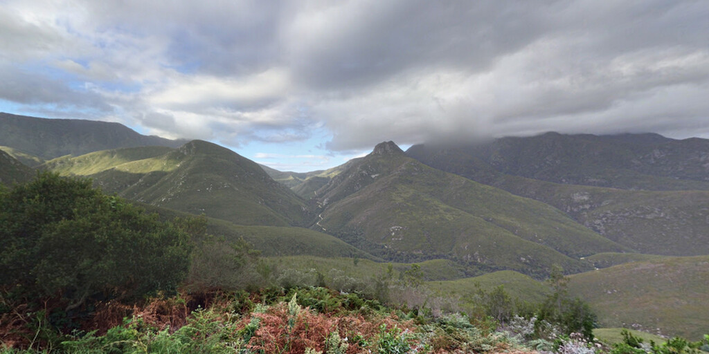
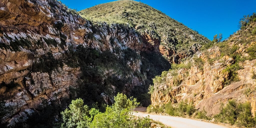
After Knysna, we drive the beautiful Prince Alfred's Pass to Uniondalen. This mostly gravel road, the R339, is probably Thomas Bain's greatest achievement. This pass was not only extremely long, but also presented its builders with almost every conceivable technical obstacle. At 68.5 km, it is by far the longest (publicly accessible) mountain pass in South Africa, and also the second-oldest, still in use, unaltered pass. You drive on sometimes very narrow gravel roads with numerous bends through beautiful gorges, forests, and over rivers.
We'll stop briefly at the King Edward VII Big Tree to take photos of this gigantic Outeniqua yellowwood (Afrocarpus falcatus) with a circumference of 7 m, measured at a height of 1.30 m. Its height is approximately 39 m. This tree germinated or planted around the year 1350, making it over 675 years old.
At the Keurbooms River, we can take a break at a nice riverside bar and restaurant, Angie's G Spot, a biker-friendly pub and restaurant at the foot of Prince Alfred's Pass. In the hamlet of Avontuur, we'll stop briefly to refuel for the next day.
The end point of the journey is the town of Uniondale, a gateway to many wonderful tourist attractions and outdoor activities, and a leader in rural development for the formerly disadvantaged KhoiSan people, boasting a wealth of high-quality handmade household goods and furniture, as well as quality gifts. Uniondale is nestled in a breathtaking landscape with magical flora and incredible geology. The town boasts beautiful historic buildings, including seven national monuments, numerous restaurants, cafes, an antique shop, and an art gallery.
 Links
Links  Usage
Usage Want to download this route?
You can download the route for free without MyRoute-app account. To do so, open the route and click 'save as'. Want to edit this route?
No problem, start by opening the route. Follow the tutorial and create your personal MyRoute-app account. After registration, your trial starts automatically.  Disclaimer
Use of this GPS route is at your own expense and risk. The route has been carefully composed and checked by a MyRoute-app accredited RouteXpert for use on TomTom, Garmin and MyRoute-app Navigation.
Changes may nevertheless have occurred due to changed circumstances, road diversions or seasonal closures. We therefore recommend checking each route before use.
Preferably use the route track in your navigation system. More information about the use of MyRoute-app can be found on the website under 'Community' or 'Academy'.

South Africa
About this region
South Africa, officially the Republic of South Africa (RSA), is the southernmost country in Africa. Its nine provinces are bounded to the south by 2,798 kilometres (1,739 miles) of coastline that stretches along the South Atlantic and Indian Ocean; to the north by the neighbouring countries of Namibia, Botswana, and Zimbabwe; to the east and northeast by Mozambique and Eswatini; and it encloses Lesotho. Covering an area of 1,221,037 square kilometres (471,445 square miles), the country has over 62 million people. Pretoria is the administrative capital, while Cape Town, as the seat of Parliament, is the legislative capital. Bloemfontein has traditionally been regarded as the judicial capital. The largest and most populous city is Johannesburg, followed by Cape Town and the busiest port city in sub-Saharan Africa, Durban.
Archaeological findings suggest that various hominid species existed in South Africa about 2.5 million years ago, and modern humans inhabited the region over 100,000 years ago. The first known people were the indigenous Khoisan, and Bantu-speaking peoples who expanded from West and Central Africa later settled in the region 2,000 to 1,000 years ago. In the north, the Kingdom of Mapungubwe formed in the 13th century. In 1652, the Dutch established the first European settlement at Table Bay, and in 1795 and 1806, the British occupied it. The Mfecane, a period of significant upheaval, led to the formation of various African kingdoms, including the Zulu Kingdom. The region was further colonised, and diamonds and gold were discovered, bringing a shift towards industrialisation and urbanisation. The Union of South Africa was created in 1910 out of the former Cape, Natal, Transvaal, and Orange River colonies, becoming a republic in 1961. Though a system of non-racial franchise had existed in the Cape, it was gradually eroded, and the vast majority of Black South Africans were not enfranchised until 1994.
The National Party imposed apartheid in 1948, institutionalising previous racial segregation. After a largely non-violent struggle by the African National Congress and other anti-apartheid activists both inside and outside the country, the repeal of discriminatory laws began in the mid-1980s. Universal elections took place in 1994, following which all racial groups have held political representation in the country's liberal democracy, which comprises a parliamentary republic and nine provinces.
South Africa is a multi-ethnic society encompassing a wide variety of cultures, languages, and religions; it is often referred to as the "rainbow nation" to describe the country's multicultural diversity, especially in the wake of apartheid. As a middle power in international affairs, South Africa maintains a significant regional influence. In addition to that, the country is a member of BRICS+, the African Union, SADC, SACU, the Commonwealth of Nations, and the G20. A developing, newly industrialised country, South Africa has the largest economy in Africa by nominal GDP. It is tied with Ethiopia for the most UNESCO World Heritage Sites in Africa, and is a biodiversity hotspot with unique biomes, plant, and animal life. Since the end of apartheid, government accountability and quality of life have substantially improved. However, crime, poverty, and inequality remain widespread. Having the highest Gini coefficient of 0.63, South Africa is considered one of the most unequal countries in the world, if not the most unequal.
Read more on Wikipedia
Archaeological findings suggest that various hominid species existed in South Africa about 2.5 million years ago, and modern humans inhabited the region over 100,000 years ago. The first known people were the indigenous Khoisan, and Bantu-speaking peoples who expanded from West and Central Africa later settled in the region 2,000 to 1,000 years ago. In the north, the Kingdom of Mapungubwe formed in the 13th century. In 1652, the Dutch established the first European settlement at Table Bay, and in 1795 and 1806, the British occupied it. The Mfecane, a period of significant upheaval, led to the formation of various African kingdoms, including the Zulu Kingdom. The region was further colonised, and diamonds and gold were discovered, bringing a shift towards industrialisation and urbanisation. The Union of South Africa was created in 1910 out of the former Cape, Natal, Transvaal, and Orange River colonies, becoming a republic in 1961. Though a system of non-racial franchise had existed in the Cape, it was gradually eroded, and the vast majority of Black South Africans were not enfranchised until 1994.
The National Party imposed apartheid in 1948, institutionalising previous racial segregation. After a largely non-violent struggle by the African National Congress and other anti-apartheid activists both inside and outside the country, the repeal of discriminatory laws began in the mid-1980s. Universal elections took place in 1994, following which all racial groups have held political representation in the country's liberal democracy, which comprises a parliamentary republic and nine provinces.
South Africa is a multi-ethnic society encompassing a wide variety of cultures, languages, and religions; it is often referred to as the "rainbow nation" to describe the country's multicultural diversity, especially in the wake of apartheid. As a middle power in international affairs, South Africa maintains a significant regional influence. In addition to that, the country is a member of BRICS+, the African Union, SADC, SACU, the Commonwealth of Nations, and the G20. A developing, newly industrialised country, South Africa has the largest economy in Africa by nominal GDP. It is tied with Ethiopia for the most UNESCO World Heritage Sites in Africa, and is a biodiversity hotspot with unique biomes, plant, and animal life. Since the end of apartheid, government accountability and quality of life have substantially improved. However, crime, poverty, and inequality remain widespread. Having the highest Gini coefficient of 0.63, South Africa is considered one of the most unequal countries in the world, if not the most unequal.
View region
 Statistics
  22
22Amount of RX reviews (South Africa)
 1199
1199Amount of visitors (South Africa)
 12
12Amount of downloads (South Africa)