08 Trabzon to Ordu via Sumela Monastery

This route was brought to you by:
RouteXpert Yannis Papadiotis (wheelboy)
Last edit: 07-01-2026
 Route Summary
 Turkey isn’t just a country, it’s a rider’s playground. This is the 8th of 12 stage journey takes you from Aegean coastlines through mountains, plains, and fairytale valleys all the way to the Black Sea and back west again.
Each leg has its own flavor, so here’s a deeper look.
Route 8:
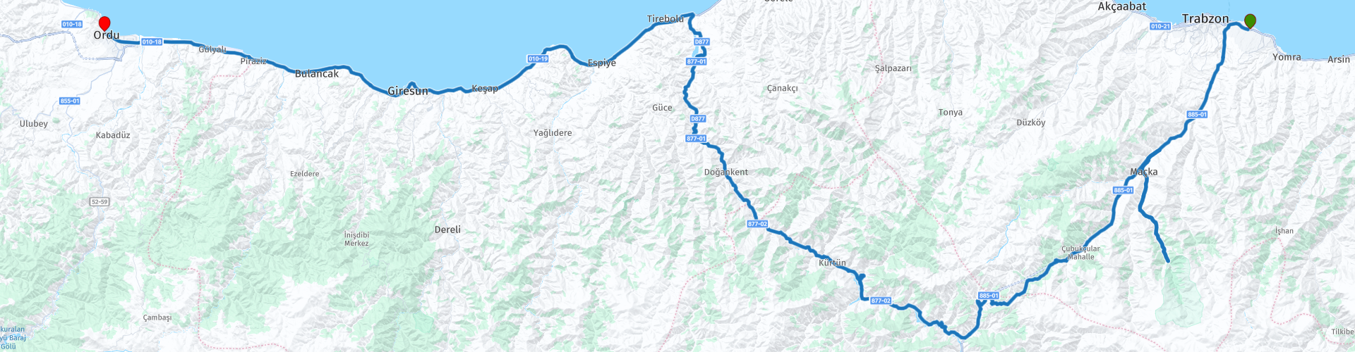
From Trabzon to Ordu, this route climbs deep into the Pontic Mountains before descending to the Black Sea coast. Highlights include the dramatic Sumela Monastery, the climatic boundary at Zigana Pass, and the option to ride the historic old Zigana Tunnel or bypass it via Europe’s longest twin-tube tunnel. River views along the Doğankent (Harşit) River, alpine forests and high altitude asphalt define the middle section before the ride relaxes onto the coastal road toward Ordu. With strong cultural landmarks, varied landscapes and excellent road quality.
This route is a 5* experience, blending mountain drama with a calm seaside arrival.
 Share this route


Animation

Verdict


Duration
8h 24m

Mode of travel
Car or motorcycle

Distance
293.04 km

Countries

 RouteXpert Review
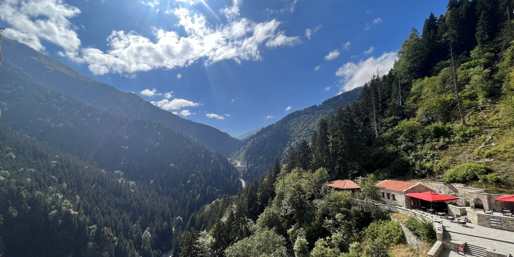
 Entrance to the site costs approximately 20€, excluding the shuttle fee of about 4€ but the setting and history fully justify the expense.
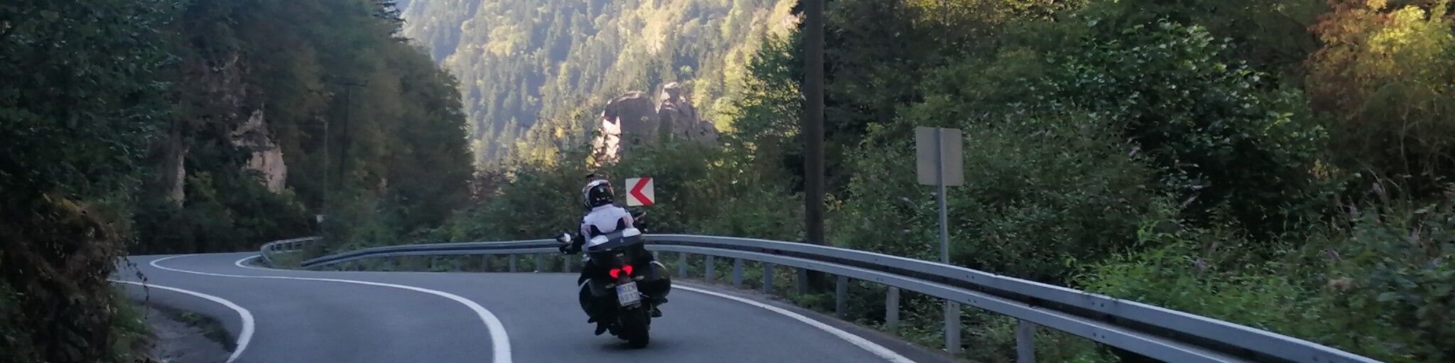
After Sumela, the road continues upward toward Zigana Pass, where the landscape and climate visibly shift. Exiting the old Zigana Tunnel, just 1,702 meters long, is a natural pause point. Here, at around 1,840 meters, dense, humid forests begin to thin, giving way to drier, harsher plateaus. The contrast is striking and immediate. Above you rises Zigana Mountain itself, reaching nearly 2,190 meters, reinforcing the sense of crossing a true natural boundary between regions.
From this point, the descent follows the course of the Doğankent Stream, also known as the Harşit River. Stretching 160 kilometers from the mountains of Gümüşhane to the Black Sea near Tirebolu, the river has long shaped trade and movement, once serving as a Silk Road corridor. Today, it is heavily harnessed for hydroelectric power, feeding a chain of dams that dominate the valley. At the entrance of Doğankent, a small waterfall appears on the left, an easy photo stop before rolling into town. After roughly five hours on the road, Doğankent itself is a sensible place for lunch, offering simple local restaurants before the ride turns west again.
A fuel stop at Demirci prepares you for the final leg. From here, the route joins the coastal road, with the Black Sea on your right, stretching endlessly alongside you as the road flattens and traffic increases. The cool mountain air gives way to sea humidity, and the ride becomes more relaxed, almost meditative, all the way into Ordu.
There is a clear route choice after Sumela.
The primary and more rewarding option is the old D885 road via Zigana Pass and the old tunnel, the highest paved section of the route mentioned above. But riders seeking comfort can instead continue straight through the new Zigana Tunnel, a 14.5 km engineering giant, currently the longest twin-tube road tunnel in Europe. It bypasses weather and altitude but sacrifices the dramatic mountain experience.
The landscape character is predominantly mountain and alpine forest, transitioning into river valleys and finally coastal scenery near Ordu. Road character ranges from twisty mountain asphalt and exposed highland sections to fast, flowing coastal highway, with tunnels smoothing the more demanding terrain. As you arrive in Ordu, the scenery softens and turns unmistakably green. This region is globally significant for one reason above all others: hazelnuts. Ordu sits at the heart of Turkey’s hazelnut production, a crop that makes the country the world’s largest exporter. The hills surrounding the city are carpeted with hazelnut orchards, their neat rows climbing slopes that seem almost too steep for agriculture. For generations, local families have depended on this harvest, and even today the rhythm of life here follows the agricultural calendar.
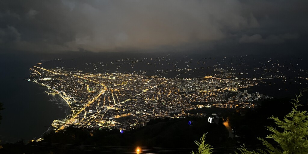
After checking in at Anemon Ordu Hotel, the city offers an easy evening exploration. Boztepe reached by cable car delivers sweeping views over Ordu and the Black Sea. The Taşbaşı Church reflects the city’s multicultural past while the seaside promenade an old naval ship open to visitors, and landmarks like the Ters Ev add lighter, relaxed stops.
Ordu feels calm and coastal, a gentle landing after a demanding and visually rich mountain stage.
 Links
Links  Usage
Usage Want to download this route?
You can download the route for free without MyRoute-app account. To do so, open the route and click 'save as'. Want to edit this route?
No problem, start by opening the route. Follow the tutorial and create your personal MyRoute-app account. After registration, your trial starts automatically.  Disclaimer
Use of this GPS route is at your own expense and risk. The route has been carefully composed and checked by a MyRoute-app accredited RouteXpert for use on TomTom, Garmin and MyRoute-app Navigation.
Changes may nevertheless have occurred due to changed circumstances, road diversions or seasonal closures. We therefore recommend checking each route before use.
Preferably use the route track in your navigation system. More information about the use of MyRoute-app can be found on the website under 'Community' or 'Academy'.

Ordu
About this region
Ordu (Turkish pronunciation: [ˈoɾdu]) or Altınordu is a port city on the Black Sea coast of Turkey, historically also known as Cotyora or Kotyora (Pontic: Κοτύωρα), and the capital of Ordu Province with a population of 217,640 in the city center.
Read more on Wikipedia
View region
 Statistics
  2
2Amount of RX reviews (Ordu)
 168
168Amount of visitors (Ordu)
 2
2Amount of downloads (Ordu)
 Route Collections in this region
 Riding Across Turkey Route by Route
This route collection offers a complete journey across Turkey, combining iconic landmarks with diverse landscapes.
Starting from the Aegean coast, you explore Ephesus and Pamukkale before heading inland to Lake Salda and Sagalassos. Cappadocia forms a highlight with its unique rock formations and underground cities. The route then crosses central Anatolia’s wide plains toward the rugged east, where quieter roads and dramatic scenery dominate. A major contrast follows along the Black Sea, with green mountains and coastal views. The return west through Bursa and Pergamon adds rich history.
Overall, this is a well balanced itinerary ideal for travelers seeking variety, culture, and scenic driving.
View Route Collection